


Google Earth Images Downloader software
Google Earth Images Downloader
Released: October 31, 2023
|
Added: December 23, 2023 | Visits: 90
 google earth images downloader is a tool that help you to get offline satellite tile images from google earth (not google maps), including historical imagery. It can work without google earth installed. After downloading, there are some ways to view the offline maps: You can view downloaded...
Platforms: Windows 8, Windows 7, Windows
| License: Shareware | Cost: $55.00 USD | Size: 29.56 MB | Download (16): google earth images downloader |
Released: December 10, 2023
|
Added: December 23, 2023 | Visits: 68
 Google Hybrid Maps Downloader is a tool that can automatically download the google hybrid maps images to your PC. It can download the small tiles and save them to your hard disk. After downloading, you can view the maps offline by its tool Maps Viewer, or you can combine the small images into one...
Platforms: Windows 8, Windows 7, Windows
| License: Shareware | Cost: $29.99 USD | Size: 30.61 MB | Download (10): Google Hybrid Maps Downloader |
Released: December 10, 2023
|
Added: December 26, 2023 | Visits: 57
 Google Maps Terrain Downloader is a tool that can automatically download the google terrain maps images to your PC. It can download the small tiles and save them to your hard disk. After downloading, you can view the maps offline by its tool Maps Viewer, or you can combine the small images into...
Platforms: Windows 8, Windows 7, Windows
| License: Shareware | Cost: $29.99 USD | Size: 305.27 MB | Download (9): Google Maps Terrain Downloader |
Released: November 23, 2006
|
Added: November 23, 2006 | Visits: 6.063
 The program StitchMaps simply joins these maps.
The result is a map that is suitable for programs using raster scan.
The maps used as basis for the assembly were either created by scanning templates, or by exports from digitalized maps.
The program is available as standard and as plus...
The program StitchMaps simply joins these maps.
The result is a map that is suitable for programs using raster scan.
The maps used as basis for the assembly were either created by scanning templates, or by exports from digitalized maps.
The program is available as standard and as plus...
Platforms: Windows
| License: Shareware | Cost: $45.00 USD | Size: 554.8 KB | Download (454): StitchMaps Download |
Released: November 10, 2007
|
Added: November 20, 2007 | Visits: 6.096
 Geocode digital images with latitude, longitude, altitude, and direction information. RoboGEO stamps this information onto the actual photo or writes it to the EXIF headers, allowing you to permanently geotag and link your photos to the GPS coordinates. All writing to the EXIF and IPTC headers...
Platforms: Windows
| License: Demo | Cost: $39.95 USD | Size: 8.28 MB | Download (1179): RoboGEO Download |
Released: April 20, 2010
|
Added: April 28, 2010 | Visits: 2.264
 Only flying is more beautiful. Enjoy your travels for a second time with a flight over the globe. Simply insert start and destination point, the rest is handled by our AquaSoft Earth Pilot. This brand new AquaSoft program connects to Google Earth and produces your video. This works as easy as if...
Platforms: Windows
| License: Demo | Cost: $29.90 USD | Size: 7.25 MB | Download (299): AquaSoft Earth Pilot Download |
Added: October 06, 2013 | Visits: 338
 Our world in artistic unrealistic imagery with 70+ magical earth images with a twist.
Platforms: Mac
| License: Shareware | Cost: $0.00 USD | Size: 23.95 MB | Download (40): Earth Art Download |
Released: June 08, 2012
|
Added: June 08, 2012 | Visits: 637
GE Path is a simple and easy-to-use application that was built to create paths and add various descriptions to placemarks saved in Google Earth.
The data can also be typed into the application or pasted/exported to the clipboard. Files generated by GE-Path are exported to Google Earth.
Platforms: Windows
| License: Freeware | Download (423): GE Path Download |
Released: November 25, 2012
|
Added: November 25, 2012 | Visits: 611
 Now you can link the individuals in your family tree to the powerful mapping capabilities of Google Earth. Automatically create Placemarks for events in the lives of individuals and view a path following the movements during their lifetime. Use the timespan slider feature of Google Earth to...
Platforms: Windows
| License: Shareware | Cost: $20.00 USD | Size: 5.11 MB | Download (56): Map My Ancestors Download |
Released: August 11, 2012
|
Added: August 11, 2012 | Visits: 771
 GE-Path was developed to make paths and/or draw circles and polygons with place marks saved by Google Earth. The data can also be typed into the application or pasted/exported to the clipboard. Files generated by GE-Path are exported to Google Earth. Read kml file saved by Google Earth Link the...
Platforms: Windows, Other
| License: Freeware | Size: 1.77 MB | Download (53): GE-Path Download |
Released: August 24, 2012
|
Added: August 24, 2012 | Visits: 550
 EasyAcreage is program for WinXP or Vista program that allows you to calculate area from KML files exported out of Google Earth. This means you do not even have to leave your house to measure a field anymore. Simply use the free version of Google Earth, mark the area you wish to measure, save it...
Platforms: Windows
| License: Shareware | Cost: $20.00 USD | Size: 472 KB | Download (530): EasyAcreage Download |
Released: January 09, 2013
|
Added: January 09, 2013 | Visits: 667
 This utility can be used to analyze GPS log files and then generate graphs, summaries, reports and Google Earth (TM) compatible KML files. With the PRO version you can create trip reports with details such as drive time, drive distance, stop time, etc.
Platforms: Windows
| License: Freeware | Size: 648 KB | Download (540): KML Generator Download |
Released: January 15, 2013
|
Added: January 15, 2013 | Visits: 677
![]() Use your GPS equipped Windows Mobile device to create a Google Earth compatible KML file and track log. Also tracks total distance, elevation gain and average speed.
Use your GPS equipped Windows Mobile device to create a Google Earth compatible KML file and track log. Also tracks total distance, elevation gain and average speed.
Platforms: Windows, Pocket PC
| License: Freeware | Size: 61 KB | Download (539): Catfood Tracker Download |
Released: July 18, 2012
|
Added: July 18, 2012 | Visits: 795
 Create own true to scale maps, store online maps locally with Vivo techology, map editor, dataexchange with Google Earth by Copy and Paste, GPS enabled coordinates, import of free OpenStreatMap data and GPS Exchange and GPS logger data, compatible with "GPS for Google Earth", area calculation...
Platforms: Windows
| License: Shareware | Cost: $65.00 USD | Size: 6.36 MB | Download (398): Dr. Regener LandMap Vivo Download |
Added: May 10, 2013 | Visits: 475
This KML data can be downloaded by visitors and opened in Google Earth™, allowing your site's news to be displayed geographically.Any type of XML data can be used to create a KML document.InstallationUnpack in your modules folder (usually /sites/all/modules/) and enable under Administer > Site...
Platforms: Windows, Mac, *nix, PHP, BSD Solaris
| License: Freeware | Download (52): XML to KML 6.x-0.5 Download |
Added: August 31, 2013 | Visits: 542
specify a file name and a matrix containing latitude / longitude data and the program outputs a KML track file viewable in Google Earth.
Platforms: Matlab
| License: Freeware | Size: 10 KB | Download (42): Latitude Longitude to KML Download |
Released: January 13, 2014
|
Added: October 09, 2014 | Visits: 844
 Maps Downloader For Google Terrain is a smart tool which can help you download tile satellite images from google map fastly and stably.It can stitch tile images into one big seamless image:Software can stitch tile images into one big seamless image such as GeoTIFF and GeoJPEG. But if the...
Platforms: Windows, Windows 7, Windows Server
| License: Shareware | Cost: $49.95 USD | Size: 4.72 MB | Download (1234): Maps Downloader For Google Terrain |
Released: August 11, 2014
|
Added: October 09, 2014 | Visits: 1.061
 Maps Downloader For Google Satellite is a smart tool which can help you download tile satellite images from google map fastly and stably.It can stitch tile images into one big seamless image:Software can stitch tile images into one big seamless image such as GeoTIFF and GeoJPEG. But if the...
Platforms: Windows, Windows 7, Windows Server
| License: Shareware | Cost: $49.95 USD | Size: 4.74 MB | Download (1240): Maps Downloader For Google Satellite |
Released: August 03, 2012
|
Added: August 03, 2012 | Visits: 489
 Using advanced mapping techniques, this AutoCAD plug-in gives you the ultimate interface to place your drawings in the real world. Plex.Earth connects AutoCAD with Google Earth and our Web Services in order to provide you a set of unique features. Enhance your design, boost your productivity and...
Platforms: Windows
| License: Shareware | Cost: $109.00 USD | Size: 2.93 MB | Download (448): Plex.Earth Tools for AutoCAD Download |
Released: August 20, 2012
|
Added: August 20, 2012 | Visits: 681
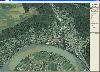
View amazing satellite images of earth with the free version of google earth software.Google earth is a totally free software which enables you zoom in from satellite,view,rotate or tilt just like a camera of the entire earth inside your pc.It works just point and click on any part of earth or by...
Platforms: Windows
| License: Freeware | Size: 798 KB | Download (529): Free Satellite images Download |