


Sensing freeware
Sensing
Added: August 11, 2013 | Visits: 562
 CSPHANTOM is a test phantom tailored to compressed sensing MRI algorithm development. It is designed to be non-sparse under a gradient transform and to contain features difficult to reproduce with partial Fourier sampling. We hope that this phantom can be used to evaluate the quality and accuracy...
Platforms: Matlab
CSPHANTOM is a test phantom tailored to compressed sensing MRI algorithm development. It is designed to be non-sparse under a gradient transform and to contain features difficult to reproduce with partial Fourier sampling. We hope that this phantom can be used to evaluate the quality and accuracy...
Platforms: Matlab
| License: Freeware | Size: 10 KB | Download (47): Compressed Sensing MRI Phantom Download |
Added: June 29, 2013 | Visits: 490
This package has solvers for constrained and unconstrained L1 minimization, which is useful for compressed sensing. u = COORDL1BREG(A,f,lambda) solves the minimization problem min_u ||u||_1 subject to A*u = fwhere A is an MxN matrix and f is a vector of length M. Input lambda is a positive...
Platforms: Matlab
| License: Freeware | Size: 10 KB | Download (44): Coordinate descent for Compressed Sensing Download |
Added: February 16, 2010 | Visits: 1.360
ORFEO Toolbox (OTB) is a high resolution remote sensing image processing library. It contains a set of algorithmic components which allow the user to capitalize on methodological know how, and therefore use an incremental approach to profit from the results of methodological research. The project...
Platforms: *nix
| License: Freeware | Download (131): ORFEO Toolbox Download |
Added: February 25, 2010 | Visits: 649
Ekahau is a synchronous interface to Ekahau location sensing system. SYNOPSIS The Ekahau class provides a straightforward synchronous interface to the Ekahau location sensing systems YAX protocol. The YAX protocol itself is asynchronous, so this module tries its best to hide that from you....
Platforms: *nix
| License: Freeware | Size: 34.82 KB | Download (117): Ekahau Download |
Added: April 24, 2013 | Visits: 470
It can be used in image recovery actions, image processing tasks, in signal processing, in simulations or optimization tasks.
Platforms: Matlab
| License: Freeware | Size: 10 KB | Download (46): Non Convex Compressed Sensing for Non Gaussian Noise Script Download |
Added: September 02, 2013 | Visits: 397
ORFEO Toolbox (OTB) is a high resolution remote sensing image processing library. It contains a set of algorithmic components which allow the user to capitalize on methodological know how, and therefore use an incremental approach to profit from the results of methodological research. The project...
Platforms: *nix
| License: Freeware | Size: 26.13 MB | Download (39): ORFEO Toolbox for Linux Download |
Added: June 13, 2013 | Visits: 333
A library collection of FORTRAN 90 subroutines and functions for the handling of raster images and for remote sensing applications. The 'fwtools' name evolved from 'framework tools'.
Platforms: *nix
| License: Freeware | Size: 61.44 KB | Download (42): fwtools Download |
Added: November 28, 2013 | Visits: 468
FMaps is here to answer the lack of user friendly opensource GIS/RS (Geographic Information System/ Remote Sensing) application on the Linux and Gnome compatible platforms.
Platforms: *nix
| License: Freeware | Size: 225.28 KB | Download (38): FMaps Download |
Released: July 17, 2012
|
Added: July 17, 2012 | Visits: 483
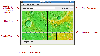 JMARS is an acronym that stands for Java Mission-planning and Analysis for Remote Sensing. It is a geospatial information system (GIS) developed by ASU's Mars Space Flight Facility to provide mission planning and data-analysis tools to NASA's orbiters, instrument team members, students of all...
Platforms: Windows, Mac, Linux
JMARS is an acronym that stands for Java Mission-planning and Analysis for Remote Sensing. It is a geospatial information system (GIS) developed by ASU's Mars Space Flight Facility to provide mission planning and data-analysis tools to NASA's orbiters, instrument team members, students of all...
Platforms: Windows, Mac, Linux
| License: Freeware | Size: 52.2 MB | Download (48): JMARS Download |
Released: November 17, 2012
|
Added: November 17, 2012 | Visits: 306
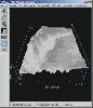
Echoproc is a piece of scientific analysis software used to extract physical ice sheet characteristics from radio echograms from experiments like the Center for the Remote sensing of ice sheets (https://www.cresis.ku.edu/)
Platforms: Windows, Mac, Linux
| License: Freeware | Size: 13.14 KB | Download (45): Echoproc Download |
Released: December 17, 2012
|
Added: December 17, 2012 | Visits: 375
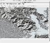
 HidroSIG is a GIS that supports raster and vectorial maps with modules oriented to the hydrological analysis, time series, remote sensing and more. It has been made 100% in java using VisAD for data visualization and using MySQL to storage all data.
Platforms: Windows, Mac, Linux
HidroSIG is a GIS that supports raster and vectorial maps with modules oriented to the hydrological analysis, time series, remote sensing and more. It has been made 100% in java using VisAD for data visualization and using MySQL to storage all data.
Platforms: Windows, Mac, Linux
| License: Freeware | Size: 151.22 MB | Download (48): HidroSIG Download |
Released: September 17, 2012
|
Added: September 17, 2012 | Visits: 682
 Open Source Remote Sensing OSSIM project, pronounced 'awesome', will leverage existing algorithms/tools/packages from the open source community in construction of the ultimate Remote Sensing/Image Processing/GIS package. osgPlanet extends OSSIM and Op
Platforms: Windows, Mac, Solaris, Linux
Open Source Remote Sensing OSSIM project, pronounced 'awesome', will leverage existing algorithms/tools/packages from the open source community in construction of the ultimate Remote Sensing/Image Processing/GIS package. osgPlanet extends OSSIM and Op
Platforms: Windows, Mac, Solaris, Linux
| License: Freeware | Size: 42.61 MB | Download (67): OSSIM - Open Source Software Image Map Download |
Released: November 11, 2012
|
Added: November 11, 2012 | Visits: 506
The Orfeo Toolbox is a C++ library for high resolution remote sensing image processing. It is developped by CNES in the frame of the ORFEO program. More information is available at www.orfeo-toolbox.org
It is based on the medical image processing library ITK and offers particular functionalities...
Platforms: Windows, Mac, BSD, Linux
| License: Freeware | Size: 39.23 MB | Download (44): OTB Download |
Released: June 16, 2012
|
Added: June 16, 2012 | Visits: 465
MATLAB driver routines for the thermoluminescence apparatus using PT100 resistors as the heating and sensing elements described in the Review of Scientific Instruments v78, 083905 (2007). [DOI: 10.1063/1.2776972]
Platforms: Windows, Mac, Linux
| License: Freeware | Size: 136.8 KB | Download (50): PT100 Thermoluminescence Rig Routines Download |
Released: December 24, 2012
|
Added: December 24, 2012 | Visits: 501
The remote sensing and GIS library is a set of C++ libraries and commands for the processing of spatial data (raster, vector and point cloud). Functionality is available through an XML interface, ideal for batch processing. Visit www.rsgislib.org
Platforms: Mac, BSD, Linux
| License: Freeware | Size: 1.55 MB | Download (52): RSGISLib Download |
Released: September 23, 2012
|
Added: September 23, 2012 | Visits: 588
Use iSentry to instantly turn your computer with web camera into a Internet-connected motion-sensing security system. Just launch iSentry, point your camera to the region you want to monitor, and prepare to receive a video or photo should any motion activity is detected.
With wide selection of...
Platforms: Mac
| License: Freeware | Size: 3 MB | Download (61): iSentry Download |
Added: May 10, 2013 | Visits: 541
It can be used in image recovery actions, image processing tasks, in signal processing, in simulations or optimization tasks. Requirements: - MATLAB 7.5 or higher
Platforms: Windows, Mac, *nix, Matlab, BSD Solaris
| License: Freeware | Download (53): Non Convex Compressed Sensing for Non Gaussian Noise Download |
Added: June 14, 2013 | Visits: 404
Polar orbiting remote sensing satellites have an orbital inclination of about 9 degrees to the vertical. Because of this georeferenced satellite scenes are not straight but slanting (rotated). It is generally useful to have a vector containing the boundary of the image. Since an image can...
Platforms: Matlab
| License: Freeware | Size: 10 KB | Download (40): GeoTiff Outliner Download |
Added: July 14, 2013 | Visits: 505
Function that convert geographic coordinates to North azimuthal equal-area map with 25 kmresolution pixel (EASE-Grid projection or NL). That projection is used mainly in remote sensing and cover the northern hemisphere.If you want to know the corresponding pixel in the EASE-Grid projection to a...
Platforms: Matlab
| License: Freeware | Size: 10 KB | Download (51): geo2easeGrid Download |
Added: September 21, 2013 | Visits: 636
This SMC Firmware Update improves the sensing and accuracy of the MagSafe Power Adapter indicator light on MacBook Air (Late 2008) computers. The updater application will be installed in the /Applications/Utilities folder and will launch automatically. Please follow the instructions in the...
Platforms: Mac
| License: Freeware | Size: 552.96 KB | Download (35): MacBook Air SMC Firmware Update Download |