


Shapefile software
Shapefile
Added: August 08, 2008 | Visits: 1.172
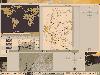
 The Natural Resources Database (NRDB) is a simple to use software tool for developing and distributing environmental databases. Data may be output as resource maps, graphs and reports using simple selections or powerful queries. The program supports UTM and other transverse mercator projections....
Platforms: Windows
The Natural Resources Database (NRDB) is a simple to use software tool for developing and distributing environmental databases. Data may be output as resource maps, graphs and reports using simple selections or powerful queries. The program supports UTM and other transverse mercator projections....
Platforms: Windows
| License: Freeware | Size: 2.89 MB | Download (519): Natural Resources Database Download |
Added: August 16, 2008 | Visits: 949
Thuban is an interactive viewer for geographic data (GIS), that offers its users diverse advanced ways and means to view and explore this type of material.It is not only a free geographical information explorer but also of open code. So, you can freely use it and also modify it if you wish. Here...
Platforms: Windows
| License: Freeware | Size: 4 KB | Download (145): Thuban Download |
Added: June 09, 2010 | Visits: 1.191
Geo::Shapelib is a Perl extension for reading and writing shapefiles as defined by ESRI. SYNOPSIS use Geo::Shapelib qw/:all/; or use Geo::Shapelib qw/:all/; my $shapefile = new Geo::Shapelib { Name => stations, Shapetype => POINT, FieldNames => [Name,Code,Founded]; FieldTypes =>...
Platforms: *nix
| License: Freeware | Size: 266.24 KB | Download (134): Geo::Shapelib Download |
Released: June 13, 2010
|
Added: September 08, 2011 | Visits: 931
 Silverlight Map Viewer is a .NET native GIS viewer control which allows developers to create interactive mapping application on the web browser. Packed with powerful AJAX interactive, simple API that makes coding easy. It is compatible with Silveright 4.0 and Visual Studio 2010. It includes many...
Platforms: Windows
Silverlight Map Viewer is a .NET native GIS viewer control which allows developers to create interactive mapping application on the web browser. Packed with powerful AJAX interactive, simple API that makes coding easy. It is compatible with Silveright 4.0 and Visual Studio 2010. It includes many...
Platforms: Windows
| License: Shareware | Cost: $199.00 USD | Size: 4.96 MB | Download (758): SwiftGIS Silverlight MapViewer Download |
Released: December 17, 2012
|
Added: January 06, 2013 | Visits: 736
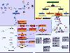 A pack of MindFusion advanced diagramming, mapping, charting, scheduling, Gantt and reporting components for WPF. The controls can be used in many types of business applications that need to visualize process management, resource planning, organizational structures, etc.
The Calendar control...
Platforms: Windows
A pack of MindFusion advanced diagramming, mapping, charting, scheduling, Gantt and reporting components for WPF. The controls can be used in many types of business applications that need to visualize process management, resource planning, organizational structures, etc.
The Calendar control...
Platforms: Windows
| License: Commercial | Cost: $850.00 USD | Size: 112.71 MB | Download (63): MindFusion.WPF Pack Download |
Released: October 24, 2012
|
Added: October 24, 2012 | Visits: 680
 QGIS supports vector, raster, and database formats and lets you browse and create map data on your computer.
Quantum GIS (QGIS) supports many common spatial data formats (e.g. ESRI ShapeFile, geotiff). QGIS supports plugins to do things like display tracks from your GPS.
QGIS aims to be an...
Platforms: Linux
QGIS supports vector, raster, and database formats and lets you browse and create map data on your computer.
Quantum GIS (QGIS) supports many common spatial data formats (e.g. ESRI ShapeFile, geotiff). QGIS supports plugins to do things like display tracks from your GPS.
QGIS aims to be an...
Platforms: Linux
| License: Freeware | Size: 1024 KB | Download (460): Quantum GIS form Linux Download |
Released: August 23, 2012
|
Added: August 23, 2012 | Visits: 669
 All-in-one software for creation of custom GPS maps compatible with Garmin GPS units. Mapwel supports routing, ESRI shapefiles, OpenStreetMap OSM, Google Earth KML and KMZ, cGPSmapper MP and GPX files. Mapwel custom GPS mapping capability and user icons editor are often used in forestry,...
Platforms: Windows
All-in-one software for creation of custom GPS maps compatible with Garmin GPS units. Mapwel supports routing, ESRI shapefiles, OpenStreetMap OSM, Google Earth KML and KMZ, cGPSmapper MP and GPX files. Mapwel custom GPS mapping capability and user icons editor are often used in forestry,...
Platforms: Windows
| License: Shareware | Cost: $45.00 USD | Size: 12.28 MB | Download (454): Mapwel Download |
Released: July 24, 2012
|
Added: July 24, 2012 | Visits: 785
 QGIS supports vector, raster, and database formats and lets you browse and create map data on your computer.
Quantum GIS (QGIS) supports many common spatial data formats (e.g. ESRI ShapeFile, geotiff). QGIS supports plugins to do things like display tracks from your GPS.
QGIS aims to be an...
Platforms: Mac
QGIS supports vector, raster, and database formats and lets you browse and create map data on your computer.
Quantum GIS (QGIS) supports many common spatial data formats (e.g. ESRI ShapeFile, geotiff). QGIS supports plugins to do things like display tracks from your GPS.
QGIS aims to be an...
Platforms: Mac
| License: Freeware | Size: 1024 KB | Download (440): Quantum GIS form Mac Download |
Released: June 22, 2012
|
Added: June 22, 2012 | Visits: 708
Thuban is an interactive geographic data viewer (GIS viewer) which features methods to visualize, explore, and analyze geographic information.
Thuban is an Interactive Geographic Data Viewer with the following features:
# Vector Data Support: Shapefile, PostGIS Layer and OGR
# Raster Data...
Platforms: Windows
| License: Freeware | Size: 11.22 MB | Download (429): Thuban for Windows Download |
Released: October 21, 2012
|
Added: October 21, 2012 | Visits: 746
Thuban is an interactive geographic data viewer (GIS viewer) which features methods to visualize, explore, and analyze geographic information.
Thuban is an Interactive Geographic Data Viewer with the following features:
# Vector Data Support: Shapefile, PostGIS Layer and OGR
# Raster Data...
Platforms: Linux
| License: Freeware | Size: 1.18 MB | Download (464): Thuban for Linux Download |
Released: January 29, 2013
|
Added: January 29, 2013 | Visits: 588
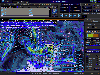
 SWIFT WX Professional runs on any desktop or laptop computer and provides you with up-to-the-minute Radar, Satellite, Storm Warnings, and Hail Reports. It will even alert you up to an hour in advance of approaching rain or thunderstorms, and predict to the nearest minute when those storms will...
Platforms: Windows
SWIFT WX Professional runs on any desktop or laptop computer and provides you with up-to-the-minute Radar, Satellite, Storm Warnings, and Hail Reports. It will even alert you up to an hour in advance of approaching rain or thunderstorms, and predict to the nearest minute when those storms will...
Platforms: Windows
| License: Shareware | Cost: $159.50 USD | Size: 20.45 MB | Download (574): SWIFT WX Professional Download |
Released: October 11, 2012
|
Added: October 11, 2012 | Visits: 778
 QGIS supports vector, raster, and database formats and lets you browse and create map data on your computer.
Quantum GIS (QGIS) supports many common spatial data formats (e.g. ESRI ShapeFile, geotiff). QGIS supports plugins to do things like display tracks from your GPS.
QGIS aims to be an...
Platforms: Windows
QGIS supports vector, raster, and database formats and lets you browse and create map data on your computer.
Quantum GIS (QGIS) supports many common spatial data formats (e.g. ESRI ShapeFile, geotiff). QGIS supports plugins to do things like display tracks from your GPS.
QGIS aims to be an...
Platforms: Windows
| License: Freeware | Size: 77.3 MB | Download (453): Quantum GIS Download |
Released: October 02, 2012
|
Added: October 02, 2012 | Visits: 580
GeoTools is an open source java GIS toolkit. Used for OGC based projects via GeoAPI interfaces. Includes two great SLD based renderers, raster access and reprojection. Plugns fo Shapefile, ArcGrid, ArcSDE, Postgis, OracleSpatial, MySQL and many more.
Platforms: Windows, Mac, Linux
| License: Freeware | Size: 44.2 MB | Download (50): GeoTools, the java GIS toolkit Download |
Released: December 13, 2012
|
Added: December 13, 2012 | Visits: 307
 Put a Map in your App! MyMaps makes it easy for Java developers to add maps to Swing applications. With access to WMS, Shapefile, Tiger and other free formats, you can add maps while avoiding the restrictive Terms of Use of those online mapping sites.
Platforms: Windows, Mac, Linux
Put a Map in your App! MyMaps makes it easy for Java developers to add maps to Swing applications. With access to WMS, Shapefile, Tiger and other free formats, you can add maps while avoiding the restrictive Terms of Use of those online mapping sites.
Platforms: Windows, Mac, Linux
| License: Freeware | Size: 11.26 MB | Download (46): MyMaps Download |
Added: May 10, 2013 | Visits: 415
SharpMap is a simple-to-use map renderer that renders GIS data for use in web and desktop applications. The engine is written in C# and based on the .NET 2.0 framework. SharpMap is released under GNU Lesser General Public LicenseFeatures - Embed the engine using any .NET language, including C#,...
Platforms: Windows, ASP.NET,
| License: Freeware | Download (61): SharpMap Download |
Added: May 10, 2013 | Visits: 493
Dia2Code is a small utility used to generate code from a Dia diagram. Dia is a program to make diagrams. If you didn't know it, you might consider checking its homepage first. Dia2Code basically reads a Dia diagram file that contains an UML class diagram and creates files in the language of...
Platforms: Windows, Mac, *nix, C/C++, BSD Solaris
| License: Freeware | Download (55): Dia2Code Download |
Added: June 04, 2013 | Visits: 497
DRAWEARTHSHADED Draws a shaded map of the Earth DRAWEARTHSHADED Draw a map of the earth, with a realistic set of colors. This can be used as a background for any map plot you wish. It is important to note that the shapefiles "landareas" and "usastateshi" are both used in order to generate this...
Platforms: Matlab
| License: Shareware | Cost: $0.00 USD | Size: 10 KB | Download (39): Shaded Earth Map Download |
Added: May 12, 2013 | Visits: 204
Import a .kml file as a series of shapefile structs. Like kml_shapefile, but more stable.Import a Google Earth .kml file of points, lines, polygons, or a combination, as a Matlab struct, compatible with the Mapping Toolbox features, and with shapefiles imported with shaperead().Structs are...
Platforms: Matlab
| License: Shareware | Cost: $0.00 USD | Size: 10 KB | Download (44): kml2struct Download |
Added: November 15, 2013 | Visits: 383
Dia2Code is a small utility used to generate code from a Dia diagram. Dia is a program to make diagrams. If you didn't know it, you might consider checking its homepage first. Dia2Code basically reads a Dia diagram file that contains an UML class diagram and creates files in the language of...
Platforms: *nix
| License: Freeware | Size: 133.12 KB | Download (35): dia2code Download |
Released: May 17, 2014
|
Added: August 09, 2014 | Visits: 900
 ATMOGRAPH is advanced weather model data visualization and analysis software for meteorologists, storm chasers, aviators, forecasters, and enthusiasts alike, allowing users to import custom GRIB data and choose from a built-in list of weather models including the GFS, NAM, HRRR, HRW, RAP, NAVGEM,...
Platforms: Windows, Windows 8, Windows 7
ATMOGRAPH is advanced weather model data visualization and analysis software for meteorologists, storm chasers, aviators, forecasters, and enthusiasts alike, allowing users to import custom GRIB data and choose from a built-in list of weather models including the GFS, NAM, HRRR, HRW, RAP, NAVGEM,...
Platforms: Windows, Windows 8, Windows 7
| License: Shareware | Cost: $200.00 USD | Size: 8.75 MB | Download (38): ATMOGRAPH ModelVis Download |