


Latitude Gym software
Latitude Gym
Released: August 24, 2012
|
Added: August 24, 2012 | Visits: 474
 The 'NZ Postcodes' package will provide you with the extended NZ Postcodes database as well as NZ geographical data like postcode, suburb, street address, latitude and longitude. The 'NZ Postcodes' database includes the information on: NZ postode, suburb, street address, latitude and longitude....
Platforms: Windows, Mac, Android, BlackBerry, iPhone, iPod, iTouch, Java, Linux, Linux Console, Linux Gnome, Linux GPL, Linux Open Source, MS-DOS, Netware, OpenVMS, Palm, Pocket PC, Symbian, Unix
| License: Shareware | Cost: $24.95 USD | Size: 781 KB | Download (51): NZ Postcodes Download |
Released: December 08, 2012
|
Added: December 08, 2012 | Visits: 508
 Your brain is much like your muscles. It needs to be trained, as muscles. Of course your life gives you pretty much of such training, but as with muscles to do your best you have to train different activities of your brain. Brain Gym is a pack of four popular mind games for your Pocket PC or...
Platforms: Windows
| License: Shareware | Cost: $24.95 USD | Size: 1.36 MB | Download (52): Brain Gym Download |
Released: December 27, 2012
|
Added: December 27, 2012 | Visits: 625
 Smarty GymBox is a Gym/health club membership management system that is easy to use. This software suit enables the user to manage its members thereby storing their details.It helps keep records of Gym members: their activities,memberships,calculate their BMI's,generate various reports,id cards,...
Platforms: Windows
| License: Demo | Cost: $49.99 USD | Size: 2.43 MB | Download (631): SMARTY GYMBOX Download |
Added: July 19, 2013 | Visits: 488
 MassGeotagger lets you select a photo, a photo folder or a folder tree and update the latitude and longitude coordinates in the EXIF data of the selected photos. To get the GPS coordinates, the method of choice is to select one or several GPX files and set the difference of time between APN time...
Platforms: Mac
| License: Shareware | Cost: $0.00 USD | Size: 4.95 MB | Download (55): MassGeotagger Download |
Added: May 10, 2013 | Visits: 394
It stores the values in a fairly naive/simple manner as mere decimal numbers.It also offers basic integration view views in order to show the values.InstallationUnpack in your modules folder (usually /sites/all/modules/) and enable under Administer > Site Building > Modules. Requirements: -...
Platforms: Windows, Mac, *nix, PHP, BSD Solaris
| License: Freeware | Download (54): CCK Latitude Longitude 5.x-1.x-dev Download |
Added: May 10, 2013 | Visits: 543
This is a program for exploring longitude/latitude based data stored in NetCDF file format. Ncvtk is built on top of the VTK toolbox. Ncvtk has been designed with the aim of offering a high degree of interactivity to scientists who have a need to explore three-dimensional, time-dependent...
Platforms: Windows, Mac, *nix, Python, BSD Solaris
| License: Freeware | Download (56): Ncvtk Download |
Added: August 08, 2013 | Visits: 678
ECEF2LLA - convert earth-centered earth-fixed (ECEF) cartesian coordinates to latitude, longitude, and altitude.USAGE:[lat,lon,alt] = ecef2lla(x,y,z)lat = geodetic latitude (radians)lon = longitude (radians)alt = height above WGS84 ellipsoid (m)x = ECEF X-coordinate (m)y = ECEF Y-coordinate (m)z...
Platforms: Matlab
| License: Freeware | Size: 10 KB | Download (46): Convert Cartesian (ECEF) Coordinates to lat, lon, alt Download |
Added: August 18, 2013 | Visits: 484
Geotagmapper adds geographical identification metadata (latitude and longitude) to the HTML header.You only have to specify your address.Installation : 1. Copy complete folder to '/wp-content/plugins/' or upload from wordpress.org 2. Activate in Plugins menu 3. Enter your address in...
Platforms: PHP
| License: Freeware | Size: 174.08 KB | Download (45): Geotagmapper Download |
Released: March 01, 2024
|
Added: March 14, 2024 | Visits: 2.690
 IP2Location IP-COUNTRY-REGION-CITY-LATITUDE-LONGITUDE-ZIPCODE-TIMEZONE-ISP-DOMAIN-NETSPEED-AREACODE-WEATHER-MOBILE-ELEVATION-USAGETYPE is commercial IP geolocation database that translates IP address to country, region, city, latitude, longitude, zip code, time zone, ISP name, domain name, net...
Platforms: Windows, Windows 8, Windows 7, Windows Server
| License: Data Only | Cost: $3399.00 USD | Size: 94.54 MB | Download (764): IP2Location Geolocation Database Download |
Released: November 10, 2007
|
Added: November 20, 2007 | Visits: 6.091
 Geocode digital images with latitude, longitude, altitude, and direction information. RoboGEO stamps this information onto the actual photo or writes it to the EXIF headers, allowing you to permanently geotag and link your photos to the GPS coordinates. All writing to the EXIF and IPTC headers...
Platforms: Windows
| License: Demo | Cost: $39.95 USD | Size: 8.28 MB | Download (1179): RoboGEO Download |
Added: January 09, 2006 | Visits: 3.144
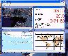 - you can show a current GPS data (Speed, Direction, Longitude, Latitude, Time, Date, Height);
- you can open any of scanned maps (in a "bmp" or "dib" format);
- you can calibrate the scanned maps yourself by two calibration points only (left-top and right-bottom);
- calibrations are stored...
- you can show a current GPS data (Speed, Direction, Longitude, Latitude, Time, Date, Height);
- you can open any of scanned maps (in a "bmp" or "dib" format);
- you can calibrate the scanned maps yourself by two calibration points only (left-top and right-bottom);
- calibrations are stored...
Platforms: Windows
| License: Demo | Cost: $9.50 USD | Size: 3.58 MB | Download (537): VIGps Download |
Released: January 07, 2006
|
Added: July 19, 2006 | Visits: 2.273
 GeoDataSource Cities Database Gold Edition contains 2.9+ million entries with city names in original language and English, feature type classifications, country names in FIPS and ISO, regions, sub-regions, state or First- Order Administrative Division, county or Second-Order Administrative...
Platforms: DOS, OS/2, BeOS, Palm OS, Windows, Mac, *nix, Windows CE
| License: Shareware | Cost: $1049.95 USD | Size: 164 KB | Download (110): GeoDataSource World Cities Database (Gold Edition) Download |
Added: August 13, 2008 | Visits: 932
 Geozip calculates distance between US (optionally Canadian) zip codes or geographical coordinates, latitude and longitude. It does take into account the curvature of the earth for calculating. You can choose miles, kilometers or nautical miles output.
Platforms: Windows
| License: Shareware | Cost: $49.00 USD | Size: 2.32 MB | Download (133): Geozip Download |
Released: October 20, 2008
|
Added: November 04, 2008 | Visits: 4.394
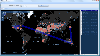 Visually see where packets travel throughout the internetwork. See through which city, state, country, IP adresses, and DNS the packets travel. You can also view the response times, ISP, latitude/longitude, packet loss and more.
Platforms: Windows
| License: Commercial | Cost: $99.99 USD | Size: 39.51 MB | Download (452): 3d Visual Trace Route Download |
Added: January 18, 2010 | Visits: 1.450
Religion::Islam::Qibla is a Perl module that calculates the Muslim Qiblah Direction, Great Circle Distance, and Great Circle Direction. SYNOPSIS use Religion::Islam::Qibla; #create new object with default options, Destination point is Kabah Lat=21 Deg N, Long 40 Deg E my $qibla =...
Platforms: *nix
| License: Freeware | Size: 4.1 KB | Download (266): Religion::Islam::Qibla Download |
Added: July 23, 2010 | Visits: 5.094
"The Simpsons" chalkboard openings project consists of a quote collection of Bart Simpsons chalkboard-writings. It is a collection of Bart Simpson’s chalkboard-writings from the opening credits of episodes of the television show “The Simpsons”, packaged up for use with the...
Platforms: *nix
| License: Freeware | Size: 5.12 KB | Download (113): The Simpsons chalkboard openings Download |
Added: June 09, 2010 | Visits: 1.331
Image::ExifTool::Location is a Perl module with easy setting, getting of an images location information. SYNOPSIS use Image::ExifTool; use Image::ExifTool::Location; my $exif = Image::ExifTool->new(); # Extract info from existing image $exif->ExtractInfo($src); # Set location...
Platforms: *nix
| License: Freeware | Size: 12.29 KB | Download (104): Image::ExifTool::Location Download |
Added: January 25, 2010 | Visits: 677
LatitudeZERO brings the geographical world of latitude and longitude coordinates into FileMaker Pro with our LatitudeZERO plug-in.Use LatitudeZERO to:Calculate the distance between two ZIP codesCalculate the distance between coordinatesReturn results in miles, kilometers or nautical...
Platforms: Mac
| License: Demo | Cost: $0.00 USD | Size: 728 KB | Download (130): LatitudeZERO Download |
Released: October 01, 2010
|
Added: October 09, 2010 | Visits: 1.606
 GeoDataSource Cities Database Titanium Edition contains 3.1+ million entries with city names in original language and English, feature type classifications, country names in FIPS and ISO, regions, sub-regions, state or First-Order Administrative Division, county or Second-Order Administrative...
Platforms: OS/2, Windows, Mac, *nix, Palm OS, Windows CE, Pocket PC, Palm OS 3.5,Palm OS 4.1,Palm OS 5,Symbian,MS-DOS,BEOS
| License: Demo | Cost: $1649.95 USD | Size: 144.51 KB | Download (824): GeoDataSource World Cities Database Download |
Released: January 01, 2011
|
Added: January 12, 2011 | Visits: 1.518
 The worlds first Enterprise back-office driven software company offering turn key software and technology services to health clubs and FREE personal training management software to independent personal trainers. We are dedicated to creating services to increase non-dues revenues, expand into new...
Platforms: Windows
| License: Freeware | Size: 465 KB | Download (128): ETrainer Desktop Download |