


Goggle Earth Satellite Maps software
Goggle Earth Satellite Maps
Released: August 13, 2012
|
Added: August 13, 2012 | Visits: 597
 Live Satellite Maps or Google maps is a web server mapping applications.Provides scrolling map images and satellite photos around the earth and even the route between different places.Since 6 October 2005, live satellite Maps is part of local Google.Google live satellite Map provides the ability...
Platforms: Windows
| License: Freeware | Size: 643 KB | Download (60): Live Satellite Maps Download |
Released: June 20, 2012
|
Added: June 20, 2012 | Visits: 610
Free Satellite Maps is a free tool from Google which offers a satellite mapping service worldwide.These are accompanied by a street service, a route planner and information about business in almost all countries.In this way we can fly the world from satellite view or in birds eye.The level of...
Platforms: Windows
| License: Freeware | Size: 612 KB | Download (47): Free Satellite Maps Download |
Added: May 10, 2013 | Visits: 520
The plugin supports Microsoft Virtual Earth, Google Maps, and OpenStreet.InstallationUnpack and upload it to the /wp-content/plugins/ directory.Activate the plugin through the 'Plugins' menu in WordPress. Requirements: - WordPress 2.5.1 up to 2.6.3
Platforms: Windows, Mac, *nix, PHP, BSD Solaris
| License: Freeware | Download (69): UMapper Download |
Released: August 11, 2014
|
Added: October 09, 2014 | Visits: 1.059
 Maps Downloader For Google Satellite is a smart tool which can help you download tile satellite images from google map fastly and stably.It can stitch tile images into one big seamless image:Software can stitch tile images into one big seamless image such as GeoTIFF and GeoJPEG. But if the...
Platforms: Windows, Windows 7, Windows Server
| License: Shareware | Cost: $49.95 USD | Size: 4.74 MB | Download (1240): Maps Downloader For Google Satellite |
Released: July 18, 2012
|
Added: July 18, 2012 | Visits: 542
Satellite earth is a software for viewing satellite and aerial imagery of the Earth.Satellite Earth allows you to enjoy virtual travel around the world, look up local information and plan trips, exploring multimedia content and share information about your trips.Explore towns, cities and terrain...
Platforms: Windows
| License: Freeware | Size: 584 KB | Download (47): Satellite Earth Download |
Released: November 10, 2007
|
Added: November 20, 2007 | Visits: 6.091
 Geocode digital images with latitude, longitude, altitude, and direction information. RoboGEO stamps this information onto the actual photo or writes it to the EXIF headers, allowing you to permanently geotag and link your photos to the GPS coordinates. All writing to the EXIF and IPTC headers...
Platforms: Windows
| License: Demo | Cost: $39.95 USD | Size: 8.28 MB | Download (1179): RoboGEO Download |
Released: March 12, 2012
|
Added: April 02, 2012 | Visits: 1.074
 Visualize your data in 3D! Quick, easy and inexpensive. Graph Earth enables management, marketing and other business professionals to create stunning visual representations of their data, all without the time and costs associated with a full-featured GIS. Viewable by Everyone! Create one of a...
Platforms: Windows
| License: Demo | Cost: $24.95 USD | Size: 469 KB | Download (96): Graph Earth Download |
Released: June 13, 2012
|
Added: June 13, 2012 | Visits: 939
 Add realistic 3D capabilities to your online Bing Maps. Bing Maps 3D brings you another step closer to knowing "what it is like out there". You can search, browse, and organize local information viewed in three dimensions, just the way it exists in the real world. This enables you to more...
Platforms: Windows
| License: Freeware | Size: 1.2 MB | Download (511): Microsoft Bing Maps 3D Download |
Released: October 13, 2012
|
Added: October 13, 2012 | Visits: 799
 NASA Earth View Live Screen Saver shows a live view of Earth as your screen saver. An amazing view of the planet from the ultimate vantage point. Shows space mission operations at times when not showing a view of Earth.
Platforms: Windows
| License: Shareware | Cost: $7.99 USD | Size: 1.11 MB | Download (58): NASA Earth View Live Screensaver Download |
Released: December 10, 2023
|
Added: December 19, 2023 | Visits: 247
 Google Maps Downloader is a tool that can automatically download the Google Maps images to your PC. It can download the small tiles and save them to your hard disk, including the normal maps, satellite maps, hybrid maps, terrain maps, customized google maps. After downloading, you can view the...
Platforms: Windows 8, Windows 7, Windows
| License: Shareware | Cost: $59.00 USD | Size: 30.6 MB | Download (70): Google Maps Downloader |
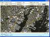
Added: August 31, 2008 | Visits: 2.605
 Demo-version of Satellite Map of Zurich is an example of how a person living in a megapolis today can use space technologies. A Quick Bird satellite shot is used as the cartographic basis. Face the reality! Your dreams are coming true with satellite maps from Transnavi.com. In the demo-version...
Platforms: Windows
| License: Freeware | Size: 18.76 MB | Download (721): Transnavicom Satellite Map of Zurich Download |
Released: September 01, 2008
|
Added: September 06, 2008 | Visits: 2.351
 ActiveEarth is a world time clock with a gorgeous day/night merge of NASA's Visible Earth satellite images in flat maps or a globe, with a row of user-definable clocks along the bottom. These clocks are beautiful, scalable, ticking, analog or digital clocks that come in several styles with many...
Platforms: Windows
| License: Demo | Cost: $24.95 USD | Size: 3.54 MB | Download (186): ActiveEarth Download |
Added: January 25, 2010 | Visits: 879
Terrabrowser is an internet browser for satellite photos and topographical maps which are obtained from the Microsoft Terra Server. The map data is provided by the U.S. Geological Survey (USGS) and therefore only covers the United States at this time (although expansion to other map servers may...
Platforms: Mac
| License: Shareware | Cost: $0.00 USD | Download (98): Terrabrowser Download |
Released: August 12, 2012
|
Added: August 12, 2012 | Visits: 469
 FlashMaps covers the entire globe. View maps of nearly every country. Brazil shown here with the Google RoadMap overlay. A powerful compass feature allows you to freely rotate any map, and move the map incrementally in North, South, East, or West directions. Instantly re-center onto any common...
Platforms: Not Applicable
| License: Commercial | Cost: $5.00 USD | Size: 31 KB | Download (47): FlashMaps Download |
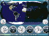
Added: August 31, 2008 | Visits: 2.128
A comprehensive astronomy / space / satellite-tracking package. It allows you to view: An earth map, showing day and night regions, location of the Moon and current phase, and position of a selected earth satellite. Panel showing positions of planets and a selected asteroid or comet, both...
Platforms: Windows
| License: Freeware | Size: 7 MB | Download (225): Home Planet Download |
Released: July 01, 2012
|
Added: July 01, 2012 | Visits: 755
 Atom GPS freeware easily geotags your photos directly from your GPS device or track log. By simply connecting your GPS Device to Atom GPS and selecting your photos you can add their geolocation in one click. This action allows you to write the geolocation data to your photos exifs (information...
Platforms: Windows
| License: Freeware | Size: 7.58 MB | Download (430): ATOM GPS Download |
Released: September 02, 2012
|
Added: September 02, 2012 | Visits: 489
 The Map View SDK is available as a stand alone Developer kit. The Map View SDK offers a Direct DLL method to draw multi-type maps by region within your application. The satellite maps and the street maps will be easily used as background maps within your application such as GIS. The Map View SDK...
Platforms: Windows
| License: Shareware | Cost: $999.95 USD | Size: 1.12 MB | Download (45): Map View SDK Download |
Released: November 18, 2012
|
Added: November 18, 2012 | Visits: 362
Did you ever want to add high-resolution maps of your trips to your photo album? No problem with myPhotoMap.
You can select from a broad variety of map types: OpenStreetMap Mapnik, Osmarender, MapQuest, OpenCycleMap and Cloudmade. Additionally satellite maps from NASA BlueMarble and NearMap...
Platforms: Mac
| License: Commercial | Cost: $4.99 USD | Size: 2.8 MB | Download (57): myPhotoMap Download |
Added: August 29, 2013 | Visits: 503
Organizing and filtering the spots from your favourite DX Cluster for DXing, Contesting or casual rag-chewing. It supports close to a hundred radios, automatically tuning to the spots you are interested in, swinging your beam around. Alerting you to rare contacts or Band Openings and looking up,...
Platforms: Mac
| License: Freeware | Size: 102.4 KB | Download (37): Cabrillo2ADIF Download |
Added: August 30, 2008 | Visits: 1.517
 Take a virtual reality tour of the planet Mars and get 3D views of surroundings or soil samples. 4GB on DVD... Covers the years 2004-2007 of the MER-Mars Exploration Rover Spirit Mission... 6 quickly switchable resolutions of viewing. See many Martian panoramas from any angle, craters, mountains,...
Platforms: Windows
| License: Demo | Cost: $23.00 USD | Size: 11.53 MB | Download (572): VRMars-Spirit - The Red Planet Mars 3D Download |