


Garmin Etrex software
Garmin Etrex
Added: June 21, 2010 | Visits: 1.470
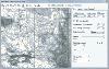
 QLandkarte can view and upload map files, track and waypoint data to your Garmin GPS receiver. Garmins MapSource software is hardly the only reason for me to boot into Windows and it does not look like Garmin ever wants to address Linux users by writing a portable piece of software. So I...
Platforms: *nix
| License: Freeware | Size: 972.8 KB | Download (116): QLandkarte Download |
Released: March 01, 2010
|
Added: April 22, 2010 | Visits: 2.518
Mapyx Quo is an intuitive, easy to learn and, surprisingly simple-to-use digital mapping program which enables you to connect your GPS to your PC and manage all your waypoints, routes and tracks. View information such as elevation, distance, speed, ETA and many more. Quo supports numerous...
Platforms: Windows, Windows CE
| License: Freeware | Size: 44.95 MB | Download (7377): Mapyx Quo Download |
Released: August 23, 2012
|
Added: August 23, 2012 | Visits: 667
 All-in-one software for creation of custom GPS maps compatible with Garmin GPS units. Mapwel supports routing, ESRI shapefiles, OpenStreetMap OSM, Google Earth KML and KMZ, cGPSmapper MP and GPX files. Mapwel custom GPS mapping capability and user icons editor are often used in forestry,...
Platforms: Windows
| License: Shareware | Cost: $45.00 USD | Size: 12.28 MB | Download (454): Mapwel Download |
Released: June 20, 2012
|
Added: June 20, 2012 | Visits: 782
GPX and TCX file welder is a small, easy to use application specially designed to help you substitute the missing GPS information in Garmin TCX files when devices lacking a GPS receiver are used to collect training data (Garmin FR 60, heartrate and pedometer only).
This application is also...
Platforms: Windows
| License: Freeware | Download (425): GPX and TCX file welder Download |
Released: August 13, 2012
|
Added: August 13, 2012 | Visits: 459
Allows you to load custom points of interest into your unit. The input files can be downloaded from the internet or you can create your own. With POI Loader, you can configure the unit to alert you when you are within a certain distance of a point or if you are driving over a certain speed near a...
Platforms: Mac
| License: Freeware | Size: 10.3 MB | Download (52): Garmin POI Loader for Mac OS Download |
Released: June 07, 2012
|
Added: June 07, 2012 | Visits: 383
This application converts the XML Polar file (from polarpersonaltrainer.com) to TCX Garmin file. All websites which register your trainers don't allow XML files from Polar. Tested with these models: RS300X, CS200
Platforms: Windows, Mac, Linux
| License: Freeware | Size: 352.08 KB | Download (57): XML Polar to TCX Garmin Converter Download |
Added: June 19, 2013 | Visits: 351
This is a MacOSX framework to communcate with Garmin USB devices.
Platforms: Mac
| License: Freeware | Size: 30.72 KB | Download (36): GarminKit Download |
Added: August 05, 2013 | Visits: 409
GPStrans is a program which allows track, route, and waypoint data to be transferred to and from a Garmin GPS. It also supports Mayko mXmap formats which enable you to create a route using your 'favorite' map and load the data into the GPS. Tracks r
Platforms: *nix
| License: Freeware | Size: 81.92 KB | Download (41): gpstrans Download |
Added: November 27, 2013 | Visits: 669
Garble is a portable modular C++ program and library for interfacing to Garmin GPS receivers.
Platforms: *nix
| License: Freeware | Size: 20.48 KB | Download (41): Garble Download |
Added: September 15, 2006 | Visits: 3.030
 Create thumbnail based web photo galleries. Interfaces with Garmin GPS units for creating georeferenced images, EXIF support, customizable HTML template files, integrated FTP, program automation, image batch processor, XML image description support, copyright stamper, built-in e-mailer, an HTTP...
Platforms: Windows
| License: Commercial | Cost: $39.95 USD | Size: 4.7 MB | Download (219): RoboPhoto Download |
Released: November 10, 2007
|
Added: November 20, 2007 | Visits: 6.091
 Geocode digital images with latitude, longitude, altitude, and direction information. RoboGEO stamps this information onto the actual photo or writes it to the EXIF headers, allowing you to permanently geotag and link your photos to the GPS coordinates. All writing to the EXIF and IPTC headers...
Platforms: Windows
| License: Demo | Cost: $39.95 USD | Size: 8.28 MB | Download (1179): RoboGEO Download |
Added: August 10, 2008 | Visits: 3.462
Add GPS support to your C# or VB.NET application.Works with Garmin, Magellan, Navman or any NMEA 0183 enabled GPS. Support for UTM, SPCS (NAD83/NAD27), British National Grid, Swiss Grid, Irish Grid and many more national coordinate systems. Many examples included to get you started. For Windows...
Platforms: Windows, Windows CE
| License: Shareware | Cost: $79.00 USD | Size: 186 KB | Download (540): GpsTools .NET Download |
Added: January 25, 2010 | Visits: 1.308
GPS Connect is a freeware program for Mac OS X which offers connectivity to Garmin GPS receivers. The intended use is to backup waypoints from the GPS to your computer. Downloaded waypoints may be saved in a native file format or exported to a variety of other formats such as tab-delimited,...
Platforms: Mac
| License: Freeware | Size: 1.2 MB | Download (108): GPS Connect Download |
Added: January 25, 2010 | Visits: 742
MacCaching is a Geocache Manager support Garmin and Magallen GPS receivers. Caches are managed in Lists which can be groups of caches in a certain area, caches you own, or caches you haven't found yet. An iPod or Palm-based device can be used for Paperless Caching when sending caches to your GPS....
Platforms: Mac
| License: Freeware | Download (104): MacCaching Download |
Added: January 25, 2010 | Visits: 1.471
HoudahGPS allows you to transfer track log and waypoint data from your Garmin, Magellan or Wintec GPS devices. It connects via USB to the Garmin and Magellan devices. It interfaces with the Wintec WBT-100, WBT-101 and WBT-201 devices using Bluetooth. HoudahGPS may also be used to convert between...
Platforms: Mac
| License: Freeware | Download (122): HoudahGPS Download |
Released: July 21, 2010
|
Added: September 25, 2010 | Visits: 1.351
 Toolkit to add GPS and coordinate conversion functionality to your software and scripts (GPS API). All NMEA0183 protocol versions are supported and can be filtered by NMEA sentence type and talker ID. Garmin USB PVT support. Information on GPS status can also be retrieved: GPS fix quality,...
Platforms: Windows
| License: Shareware | Cost: $99.00 USD | Size: 2.2 MB | Download (125): Eye4Software GPS API Download |
Released: October 13, 2012
|
Added: October 13, 2012 | Visits: 419
Allows you to install and manage maps on your Garmin GPS device.
Platforms: Mac
| License: Freeware | Size: 40 MB | Download (49): MapInstall for Mac OS Download |
Released: July 10, 2012
|
Added: July 10, 2012 | Visits: 420
Allows you to transfer track log and waypoint data from your Garmin, Magellan or Wintec GPS devices. It connects via USB to the Garmin and Magellan devices. It interfaces with the Wintec WBT-100, WBT-101 and WBT-201 devices using Bluetooth.
HoudahGPS may also be used to convert between the GPX,...
Platforms: Mac
| License: Freeware | Size: 1.3 MB | Download (53): HoudahGPS for Mac OS Download |
Released: June 07, 2012
|
Added: June 07, 2012 | Visits: 473
 Gpi2Gps converts Waypoints from Garmin GPI file format (i.e. Garmin POI Loader) to Google Earth (KMZ) or GPS compatible format (GPX) in a few steps. With GPI to GPs converter you are able to transform from GPI to GPs. Download your waypoints from your GPS or Palm PDAs and save it in .GPI format...
Platforms: Windows
| License: Demo | Cost: $20.00 USD | Size: 635 KB | Download (68): GPI to GPs converter Download |
Released: October 09, 2012
|
Added: October 09, 2012 | Visits: 433
 OkCustomMap is a software to produce Garmin Custom Maps.
Supports many map formats:
- OkMap
- Ecw
- GeoTiff
- World files
- OziExplorer
- GpsTuner
You can customize:
- The quality of the output JPEG images (0=Bad, 100=Good)
- The KML transparency (0=Transparent, 255=Opaque)
- The KML draw...
OkCustomMap is a software to produce Garmin Custom Maps.
Supports many map formats:
- OkMap
- Ecw
- GeoTiff
- World files
- OziExplorer
- GpsTuner
You can customize:
- The quality of the output JPEG images (0=Bad, 100=Good)
- The KML transparency (0=Transparent, 255=Opaque)
- The KML draw...
Platforms: Windows
| License: Freeware | Size: 3.22 MB | Download (56): OkCustomMap Download |