


Kml freeware
Kml
Added: January 25, 2010 | Visits: 1.012
 Earth Addresser takes the addresses from your Address Book and writes them to a 'KML' file which Google Earth can open to display your friends' places right on the map. If you have added photos for them in your Address Book, those will appear instead of the usual drawing pin.
Platforms: Mac
| License: Freeware | Size: 98 KB | Download (111): Earth Addresser Download |
Added: June 11, 2010 | Visits: 999
GeoServer project connects your information to the Geospatial Web. With GeoServer, you can publish and edit data using open standards. Your information is made available in a large variety of formats as maps/images or actual geospatial data. GeoServers transactional capabilities offer robust...
Platforms: *nix
| License: Freeware | Size: 25.9 MB | Download (104): GeoServer Download |
Released: October 20, 2012
|
Added: October 20, 2012 | Visits: 690
 Features:
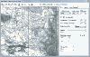
View 24K or 100K topographic maps and other topographic data.
Displays maps in 2-D or 3-D, including elevation profiles.
View and rotate maps at any angle.
Create waypoints and routes on your computer and transfer maps, waypoints, routes, tracks and geotagged photos between your...
Features:
View 24K or 100K topographic maps and other topographic data.
Displays maps in 2-D or 3-D, including elevation profiles.
View and rotate maps at any angle.
Create waypoints and routes on your computer and transfer maps, waypoints, routes, tracks and geotagged photos between your...
Platforms: Mac
| License: Freeware | Size: 51 MB | Download (67): Garmin BaseCamp for Mac OS Download |
Released: November 25, 2012
|
Added: November 25, 2012 | Visits: 591
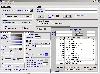
KML Editor is a small, Java based application specially designed to offer user a simple editor for KML files suitable for Google Maps, Google Earth and other applications.
This editor allows for raw text editing, addition of timestamps and timespans for placemarks, and merging of KML files....
Platforms: Windows
| License: Freeware | Download (65): KML Editor Download |
Released: June 25, 2012
|
Added: June 25, 2012 | Visits: 278
A simple and still alpha Python script to extract features out of an OpenStreetMap (OSM) file into basic Keyhole markup language (KML)
Platforms: Windows, Mac, Linux
| License: Freeware | Size: 14.71 KB | Download (63): osm2kml Download |
Added: May 10, 2013 | Visits: 516
Uses a filter to embed a google map overlayed with a KML file using square brackets like [mykml:homepage (41.88414, -87.63238), 10] The general syntax is [mykml:path-to-kml (lat,lon), zoom]InstallationUnpack in your modules folder (usually /sites/all/modules/) and enable under Administer > Site...
Platforms: Windows, Mac, *nix, PHP, BSD Solaris
| License: Freeware | Download (58): MyKML Filter 5.x-2.0 Download |
Added: May 10, 2013 | Visits: 470
KML is short for Keyhole Markup Language. It is a form of XML that is widely used for transferring geographic information, chiefly to Google Earth but also to other systems that can understand KML.The format can be used to transfer points, lines and shapes - both 2D and 3D - though this module...
Platforms: Windows, Mac, *nix, PHP, BSD Solaris
| License: Freeware | Download (57): KML module Download |
Released: June 20, 2012
|
Added: June 20, 2012 | Visits: 694
 Make graph into Googlr Earth to illustrate your presentations, papers, etc. GE-Graph was developed to generate graphs from kml files saved by GE. The file generated by GE-Graph can be exported to Google Earth. Make Bars graph Make graph with geometrical shapes (circles, squares, triangles, etc)....
Platforms: Windows
| License: Freeware | Size: 1.81 MB | Download (57): GE-Graph Download |
Released: October 16, 2012
|
Added: October 16, 2012 | Visits: 668
PhotoKML can be used to generate KML files that show pictures on the Google Earth map. You can either import pictures that are already geo-referenced or link your picture with a GPS track. The tool will generate a self contained kmz file that include all the icosn & thumbnails versions of the...
Platforms: Mac
| License: Freeware | Size: 235.52 KB | Download (57): PhotoKML Download |
Released: October 09, 2012
|
Added: October 09, 2012 | Visits: 433
 OkCustomMap is a software to produce Garmin Custom Maps.
Supports many map formats:
- OkMap
- Ecw
- GeoTiff
- World files
- OziExplorer
- GpsTuner
You can customize:
- The quality of the output JPEG images (0=Bad, 100=Good)
- The KML transparency (0=Transparent, 255=Opaque)
- The KML draw...
OkCustomMap is a software to produce Garmin Custom Maps.
Supports many map formats:
- OkMap
- Ecw
- GeoTiff
- World files
- OziExplorer
- GpsTuner
You can customize:
- The quality of the output JPEG images (0=Bad, 100=Good)
- The KML transparency (0=Transparent, 255=Opaque)
- The KML draw...
Platforms: Windows
| License: Freeware | Size: 3.22 MB | Download (56): OkCustomMap Download |
Added: May 10, 2013 | Visits: 162
The clientsidekml (egeoxml.js) from the GMap Overlay Module which is part of the GMap Addons Module needs to be working.InstallationUnpack in your modules folder (usually /sites/all/modules/) and enable under Administer > Site Building > Modules. Key features "CiviMap": - Creates themeable KML...
Platforms: Windows, Mac, *nix, PHP, BSD Solaris
| License: Freeware | Download (55): CiviMap 5.x-1.x-dev Download |
Added: May 10, 2013 | Visits: 290
These tracks are intended to be visualised on maps, plotted as distance/altitude profiles, have statistics derived from them, etc.The 'base' trackfield CCK field knows about latitude, longitude, altitude and distance.Due to the flexibility of the system, the distance/altitude pairs can be...
Platforms: Windows, Mac, *nix, PHP, BSD Solaris
| License: Freeware | Download (54): Trackfield 5.x-0.5 Download |
Released: August 11, 2012
|
Added: August 11, 2012 | Visits: 765
 GE-Path was developed to make paths and/or draw circles and polygons with place marks saved by Google Earth. The data can also be typed into the application or pasted/exported to the clipboard. Files generated by GE-Path are exported to Google Earth. Read kml file saved by Google Earth Link the...
Platforms: Windows, Other
| License: Freeware | Size: 1.77 MB | Download (53): GE-Path Download |
Released: July 10, 2012
|
Added: July 10, 2012 | Visits: 418
Allows you to transfer track log and waypoint data from your Garmin, Magellan or Wintec GPS devices. It connects via USB to the Garmin and Magellan devices. It interfaces with the Wintec WBT-100, WBT-101 and WBT-201 devices using Bluetooth.
HoudahGPS may also be used to convert between the GPX,...
Platforms: Mac
| License: Freeware | Size: 1.3 MB | Download (53): HoudahGPS for Mac OS Download |
Added: May 10, 2013 | Visits: 471
This KML data can be downloaded by visitors and opened in Google Earth™, allowing your site's news to be displayed geographically.Any type of XML data can be used to create a KML document.InstallationUnpack in your modules folder (usually /sites/all/modules/) and enable under Administer > Site...
Platforms: Windows, Mac, *nix, PHP, BSD Solaris
| License: Freeware | Download (52): XML to KML 6.x-0.5 Download |
Released: June 15, 2012
|
Added: June 15, 2012 | Visits: 391
 Application for geocaching or waymarking that allows you to import GPX or LOC files for editing. You can print out cheat sheets to take on the trail, export to KML or HTML, and send the data to your handheld GPS unit.
Platforms: Windows, Mac, Linux
| License: Freeware | Size: 19.78 MB | Download (52): TinyGPX Download |
Added: August 20, 2013 | Visits: 515
With this plugin you can have Instant GPS Tracking for your WordPress site. (Extended version of GEOTAG plugin.). You can add coordinates to your posts and display maps with these positions. On these maps you can also display KML/KMZ files or the geotags of the images of your post. The plugin...
Platforms: PHP
| License: Freeware | Size: 10 KB | Download (52): Transportlines.com Free Fleet GPS Tracking - Geotag Download |
Added: July 11, 2013 | Visits: 436
This plugin lets you save location information with posts, pages, and other WordPress objects. These objects can then be presented on interactive Google maps in many ways.ExamplesThere's a community sourced list of examples in action. People do all kinds of amazing things with Geo...
Platforms: PHP
| License: Freeware | Size: 419.84 KB | Download (51): Geo Mashup Download |
Added: July 03, 2013 | Visits: 366
GeoPress adds geographic tagging of your posts and pages. You can enter an address, points on a map, or enter latitude & longitude using the post interface. You can also include the post location within the body itself to make it easy to geotag using emailed posts and desktop clients. Maps can be...
Platforms: PHP
| License: Freeware | Size: 10 KB | Download (50): GeoPress Download |
Added: May 29, 2013 | Visits: 770
There are several plugins that can embed Google Maps into WordPress pages. However, most, if not all, of them require the user to specify the markup in a separate KML file. I found that troublesome, and hence created a plugin that allows the administrator to create a marker simply by clicking on...
Platforms: PHP
| License: Freeware | Size: 10 KB | Download (50): Organisation Maps Download |