


Autodesk Raster freeware
Autodesk Raster
Added: October 01, 2010 | Visits: 1.096
 Geo::Raster is a Perl extension for raster algebra. SYNOPSIS use Geo::Raster; or use Geo::Raster qw(:types); or use Geo::Raster qw(:types :logics :db); Geo::Raster is an object-oriented interface to libral, a C library for rasters and raster algebra. Geo::Raster makes using libral easy...
Platforms: *nix
| License: Freeware | Size: 89.09 KB | Download (108): Geo::Raster Download |
Released: October 27, 2012
|
Added: October 27, 2012 | Visits: 745
With Autodesk Design Review you can easily view and print 2D and 3D designs in DWF format. This is the smartest way to share accurate design information with those who need it.
Design Review enables your entire project or product team to view, print, measure, and markup DWF, DWG, DXF, PDF and...
Platforms: Windows
| License: Freeware | Size: 46.5 MB | Download (465): Autodesk Design Review Download |
Added: November 17, 2006 | Visits: 4.769
 Raster To Vector converter is the most powerful and absolutely free solution for digitizing vector data from image sources. It combines the power of outline vectorizing technology with many unique features such as:
- Customizable noise suppression;
- Autoincrease quality for small-sized...
Raster To Vector converter is the most powerful and absolutely free solution for digitizing vector data from image sources. It combines the power of outline vectorizing technology with many unique features such as:
- Customizable noise suppression;
- Autoincrease quality for small-sized...
Platforms: Windows
| License: Freeware | Size: 9.98 MB | Download (1074): Raster To Vector Download |
Added: August 29, 2008 | Visits: 4.383
Autodesk FBX is a free platform-independent 3D authoring and interchange format that provides access to 3D content from most 3D vendors and platforms. The FBX file format supports all major 3D data elements, as well as 2D, audio, and video media elements. Registration (Bronze Membership is free)...
Platforms: Windows, Mac, *nix
| License: Freeware | Size: 12 MB | Download (2997): Autodesk FBX Download |
Added: August 18, 2008 | Visits: 2.916
With Autodesk MotionBuilder 7 Personal Learning Edition, industry professionals and those interested in character animation have an opportunity to explore all aspects of this award-winning technology while developing new skills. This special version of MotionBuilder® provides free access to the...
Platforms: Windows, Mac
| License: Freeware | Size: 78 MB | Download (1154): Autodesk MotionBuilder Personal Learning Edition Download |
Released: November 04, 2012
|
Added: November 04, 2012 | Visits: 1.371
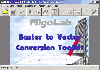 Software development kit for CAD/CAM/ GIS and graphic software developers. Converts from raster to vector and refines architect, mechanical, tech drawing, maps, math graphs, graphics for books and journals and more. ActiveX and Com Component are also available. Refines vector graphics, creates...
Platforms: Windows
| License: Freeware | Size: 2.67 MB | Download (527): Algolab Raster to Vector Conversion CAD/ Download |
Released: September 17, 2012
|
Added: September 17, 2012 | Visits: 601
Raster To Vector converter is the most powerful and absolutely free solution for digitizing vector data from image sources. It combines the power of outline vectorizing technology with many unique features such as:
- Customizable noise suppression;
- Autoincrease quality for small-sized...
Platforms: Windows
| License: Freeware | Size: 9.98 MB | Download (51): Raster To Vector Converter Download |
Released: November 12, 2012
|
Added: November 12, 2012 | Visits: 524
Delineate is a tool for converting raster images to SVG (Scalable Vector Graphics) using AutoTrace or potrace. It loads images using JIU and displays results using Batik. Input formats are JPEG, PNG, GIF, BMP, TIFF, PNM, PBM, PGM, PPM, IFF, PCD, PSD, RAS
Platforms: Windows, Mac, Linux
| License: Freeware | Size: 3.45 MB | Download (52): Delineate - raster to SVG converter Download |
Added: September 05, 2013 | Visits: 330
The script adds a header at the top of the outputted file.It needs two inputs: the grid to be exported and the the header vector with the spatial information of the grid.It can save files as .txt or .asc.
Platforms: Matlab
| License: Freeware | Size: 10 KB | Download (44): Save ASCII Raster Download |
Released: December 29, 2010
|
Added: January 06, 2011 | Visits: 4.321
 OkMap is a GPS and map software that:
-Works with vectorial maps and calibrates raster maps
-Organizes paths by creating waypoints, routes and tracks
-Uploads/downloads data to/from your GPS
-Uses altitude DEM data
-Supports GPS real-time navigation
-Sends/receives vehicles position...
OkMap is a GPS and map software that:
-Works with vectorial maps and calibrates raster maps
-Organizes paths by creating waypoints, routes and tracks
-Uploads/downloads data to/from your GPS
-Uses altitude DEM data
-Supports GPS real-time navigation
-Sends/receives vehicles position...
Platforms: Windows
| License: Freeware | Size: 20.25 MB | Download (1277): OkMap Download |
Released: November 26, 2009
|
Added: December 02, 2009 | Visits: 2.948
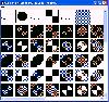 Program for visual selection of Ternary Raster Operation code.
The program represents all 256 results of the BitBlt function for all possible options for raster operation codes, allows you to visually choose the combination and copies its code to the clipboard.
Program for visual selection of Ternary Raster Operation code.
The program represents all 256 results of the BitBlt function for all possible options for raster operation codes, allows you to visually choose the combination and copies its code to the clipboard.
Platforms: Windows
| License: Freeware | Size: 180 KB | Download (541): RopTest Download |
Added: July 24, 2010 | Visits: 1.047
SANE comes from "Scanner Access Now Easy" and is an application programming interface (API) that provides standardized access to any raster image scanner hardware (flatbed scanner, handheld scanner, video and still cameras, framegrabbers, etc.). The SANE standard is public domain and its...
Platforms: *nix
| License: Freeware | Size: 3.15 MB | Download (156): SANE Download |
Added: January 25, 2010 | Visits: 1.509
McDwiff... DWF. Mac-style. Open, view, print, and convert Autodesk DWF files with this easy-to-use Mac application.Free for non-commercial use, $39 for commercial license.
Platforms: Mac
| License: Freeware | Size: 87 KB | Download (381): McDwiff Download |
Released: June 27, 2012
|
Added: June 27, 2012 | Visits: 485
GeoRefImg is a handy and reliable LISP utility designed to automatically reposition raster images from a drawing according to the position defined in the image World files.
World files define geo-position and other parameters of a raster image (TIF, CIT, JPG, PNG, GIF, BMP, ECW, SID...).
Platforms: Windows, Windows Vista, 7, 7x64
| License: Freeware | Download (435): GeoRefImg Download |
Released: November 05, 2012
|
Added: November 05, 2012 | Visits: 627
![]() Pixelitor is a handy and quite useful raster graphics editor that will help you customize your images fast and easy. This application will also allows working with layers, but it has currently no layered save format. You can only save the final composited image.
Pixelitor is a handy and quite useful raster graphics editor that will help you customize your images fast and easy. This application will also allows working with layers, but it has currently no layered save format. You can only save the final composited image.
Platforms: Windows
| License: Freeware | Size: 1013.76 KB | Download (53): Pixelitor Download |
Added: November 27, 2013 | Visits: 590
Maya2OSG is a toolkit to export or import Autodesk?*A* Maya?*A* scenes or models to/from any OpenSceneGraph (OSG) supported file format. Maya2OSG has been developed in C++ and released under GNU GPL v3. It installs as a Maya plug-in and is available from easy-to-use Shelf buttons. For more...
Platforms: *nix
| License: Freeware | Size: 3.2 MB | Download (56): Maya2OSG Download |
Added: November 25, 2013 | Visits: 388
ThanCad is a 2dimensional cad, with limited 3d support and raster inclusion capability and emphasis in engineering. It is being written in Python and since it uses the Tkinter library, it is platform independent.
Platforms: *nix
| License: Freeware | Size: 14.91 MB | Download (45): ThanCad Download |
Added: September 06, 2013 | Visits: 445
SVG canvas for wxPython pyWxSVG is a Python library that allows you to view and print SVG files or SVG content, convert SVG to raster graphics. Partial support svg format. Tested with Python 2.5 and wxPython 2.8.9.2. Path parser and elliptical arc approximation from Enable. Requirements: ?*A*...
Platforms: *nix
| License: Freeware | Size: 20.48 KB | Download (39): pyWxSVG Download |
Added: October 21, 2013 | Visits: 402
OpenEV is a software library and application for viewing and analysing raster and vector geospatial data. OpenEV is used by private companies, universities, governments and non-profit organizations around the world. OpenEV is both: * An application for displaying and analysing geospatial data...
Platforms: *nix
| License: Freeware | Size: 24.36 MB | Download (34): OpenEV Download |
Released: February 10, 2014
|
Added: February 24, 2014 | Visits: 3.831
 Print Conductor is a simple batch printing utility. If you regularly have to open and print a large number of files, this elegant tool can be a real timesaver. Manually printing several files is tedious work - it generally requires opening and printing each file separately in the applications...
Platforms: Windows, Windows 7
| License: Freeware | Size: 6.26 MB | Download (388): PrintConductor Download |