


Gps Logger Nmea software
Gps Logger Nmea
Released: April 04, 2003
|
Added: April 25, 2006 | Visits: 7.595
 XP Logon Password Logger invisibly records user name and password at Windows 2000/XP logon to a file. Then you can easily review them later. This software is based on a low-level keyboard driver and is absolutely undetectable for end-user. It works on Windows 2000 and Windows XP.
Platforms: Windows
| License: Freeware | Size: 127 KB | Download (1650): XP Logon Password Logger Download |
Released: March 15, 2008
|
Added: April 30, 2008 | Visits: 4.638
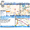 With MobiumGPS , your Windows Mobile device is turned into an advanced Mobile Navigation System with turn-by-turn voice announcements and detailed driving directions. You can search over 15 million point of interests (POIs) - places like hotels, restaurants, shopping malls and other tourist...
Platforms: Windows
| License: Demo | Cost: $9.95 USD | Size: 806.13 KB | Download (1554): Mobium GPS Navigation System Download |
Released: September 08, 2009
|
Added: September 14, 2009 | Visits: 3.870
 PhotoGPSEditor is an easy to use meta-data editor for photo (JPEG, RAW) files, plus it can match data from GPS (gpx or NMEA) files. The program is freeware, however, donations can be made to help support future development. With PhotoGPSEditor you can add location and summary details to a...
Platforms: Mac
| License: Freeware | Size: 2.39 MB | Download (1330): PhotoGPSEditor Download |
Released: December 29, 2010
|
Added: January 06, 2011 | Visits: 4.315
 OkMap is a GPS and map software that:
-Works with vectorial maps and calibrates raster maps
-Organizes paths by creating waypoints, routes and tracks
-Uploads/downloads data to/from your GPS
-Uses altitude DEM data
-Supports GPS real-time navigation
-Sends/receives vehicles position...
OkMap is a GPS and map software that:
-Works with vectorial maps and calibrates raster maps
-Organizes paths by creating waypoints, routes and tracks
-Uploads/downloads data to/from your GPS
-Uses altitude DEM data
-Supports GPS real-time navigation
-Sends/receives vehicles position...
Platforms: Windows
| License: Freeware | Size: 20.25 MB | Download (1277): OkMap Download |
Released: November 10, 2007
|
Added: November 20, 2007 | Visits: 6.089
 Geocode digital images with latitude, longitude, altitude, and direction information. RoboGEO stamps this information onto the actual photo or writes it to the EXIF headers, allowing you to permanently geotag and link your photos to the GPS coordinates. All writing to the EXIF and IPTC headers...
Platforms: Windows
| License: Demo | Cost: $39.95 USD | Size: 8.28 MB | Download (1179): RoboGEO Download |
Released: January 24, 2011
|
Added: February 17, 2011 | Visits: 2.464
 GPS log-maker. Software create *.plt track file, *.rte route file and, optionally, NMEA-log file.
The program from TL_Gate*.cab can work via COM-port or Franson GpsGate software API, but it requires installed GpsGate in any case. If GpsGate is installed the best way is to use it.
TrackLog...
GPS log-maker. Software create *.plt track file, *.rte route file and, optionally, NMEA-log file.
The program from TL_Gate*.cab can work via COM-port or Franson GpsGate software API, but it requires installed GpsGate in any case. If GpsGate is installed the best way is to use it.
TrackLog...
Platforms: Windows
| License: Freeware | Size: 91.3 KB | Download (1002): DXsoft TrackLog Download |
Released: August 15, 2013
|
Added: August 20, 2013 | Visits: 968
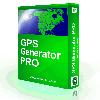 The GPS Generator PRO application is designed for providing assitance in developing, testing and debugging programs and equipment working with the NMEA-0183 protocol. This application can also be used for learning and testing navigation applications and equipment before purchasing.
GPS Generator...
The GPS Generator PRO application is designed for providing assitance in developing, testing and debugging programs and equipment working with the NMEA-0183 protocol. This application can also be used for learning and testing navigation applications and equipment before purchasing.
GPS Generator...
Platforms: Windows, Other
| License: Shareware | Cost: $84.99 USD | Size: 4.3 MB | Download (994): GPS Generator PRO Download |
Added: March 12, 2006 | Visits: 12.988
 HS GPS is a software library (with full C source code) which provides access to a NMEA-183 compliant GPS receiver via a serial communications port, decoding NMEA sentences: $GPGGA, $GPGSA, $GPGSV, $GPGLL, $GPRMC and $GPVTG. Decoded parameters include: time, date, position, altitude, speed, course...
Platforms: Palm OS, Windows
| License: Freeware | Size: 309 KB | Download (973): HS NMEA GPS C Source Library 1.0 Download |
Released: April 09, 2010
|
Added: July 05, 2010 | Visits: 3.474
 The Tro GPS Simulator provides a complete suite for all your GPS simulating needs and more. The Tro GPS Simulator uses the international standardized protocol NMEA-0183 for GPS data exchange. It can simulataneously send and recieve data.Furthermore it provides several input methods for GPS...
Platforms: Windows
| License: Demo | Cost: $99.00 USD | Size: 5.73 MB | Download (884): Tro GPS Simulator Download |
Released: January 25, 2010
|
Added: August 18, 2010 | Visits: 1.059
 Set of programs to convert GPS-tracks of *.gpx, *.mps, *.plt or *.nmea format to route files *.rt2. Software creates two route files - forward route and backward one.
Platforms: Windows
| License: Freeware | Size: 26.06 KB | Download (878): Gpx2rt2 Download |
Released: May 25, 2018
|
Added: June 25, 2018 | Visits: 3.605
 HoudahGeo is a photo geocoding and geotagging tool for Mac. Use HoudahGeo to attach GPS coordinates and location names to your photos.
HoudahGeo writes EXIF and XMP geotags to JPEG and RAW image files. This creates a permanent record of where a photo was taken. Just like a GPS-enabled camera....
HoudahGeo is a photo geocoding and geotagging tool for Mac. Use HoudahGeo to attach GPS coordinates and location names to your photos.
HoudahGeo writes EXIF and XMP geotags to JPEG and RAW image files. This creates a permanent record of where a photo was taken. Just like a GPS-enabled camera....
Platforms: Mac
| License: Demo | Cost: $39.00 USD | Size: 22.87 MB | Download (837): HoudahGeo Download |
Added: August 23, 2008 | Visits: 2.321
RS232 Data Logger by Eltima Software is an Open Source application which allows you to redirect all communication data from RS232 compliant serial port device into a text file for further analysis. Redirects data from any available serial port (doesn't matter whether it is virtual or real one)...
Platforms: Windows
| License: Freeware | Size: 745 KB | Download (783): Eltima RS232 Data Logger Download |
Released: July 01, 2008
|
Added: July 03, 2008 | Visits: 3.591
 Pictomio is a software application for managing, categorizing, searching, and archiving photos, videos and other media files, and allows you to generate animated 2D and 3D slideshows. The extensive capabilities of the latest programmable 3D graphic cards are utilized for image decoding and...
Platforms: Windows, Windows Vista
| License: Freeware | Size: 6.1 MB | Download (755): pictomio Download |
Released: September 26, 2010
|
Added: September 30, 2010 | Visits: 1.445
 Keep track of driving records. Records include: maximum driving, minimum driving, start date, end date, start time, end time, start location, end location, start mi/km, end mi/km. There is a feature to export your records to Excel.
Platforms: Windows
| License: Shareware | Cost: $19.99 USD | Size: 777 KB | Download (692): Driving Log Software Download |
Released: January 20, 2012
|
Added: March 05, 2013 | Visits: 846
 A program to convert GPS-track of *.gpx, *.mps, *.plt or *.nmea format to Navitel Tracks.bin "blue line" file.
Platforms: Windows
| License: Freeware | Size: 31.64 KB | Download (623): Gpx2bin Download |
Released: December 22, 2012
|
Added: December 22, 2012 | Visits: 468
 Run.GPS Trainer UV is the perfect tool to take along doing all sorts of sports like running, skiing, hiking, and many more. Run.GPS Trainer UV is compatible with most PocketPCs and Smartphones (requires Windows Mobile 2003 Pocket PC, Windows Mobile 5 or Windows Mobile 6). Recording *...
Platforms: Windows, Pocket PC
| License: Shareware | Cost: $33.99 USD | Size: 6.29 MB | Download (600): Run.GPS Trainer UV Download |
Added: August 10, 2008 | Visits: 3.457
Add GPS support to your C# or VB.NET application.Works with Garmin, Magellan, Navman or any NMEA 0183 enabled GPS. Support for UTM, SPCS (NAD83/NAD27), British National Grid, Swiss Grid, Irish Grid and many more national coordinate systems. Many examples included to get you started. For Windows...
Platforms: Windows, Windows CE
| License: Shareware | Cost: $79.00 USD | Size: 186 KB | Download (540): GpsTools .NET Download |
Released: January 09, 2013
|
Added: January 09, 2013 | Visits: 662
 This utility can be used to analyze GPS log files and then generate graphs, summaries, reports and Google Earth (TM) compatible KML files. With the PRO version you can create trip reports with details such as drive time, drive distance, stop time, etc.
Platforms: Windows
| License: Freeware | Size: 648 KB | Download (540): KML Generator Download |
Released: October 23, 2012
|
Added: October 23, 2012 | Visits: 566
 Use GPS without GPS receiver! Try this advanced GPS device simulator (virtual GPS receiver). It can be used for development purposes or for testing GPS software before buying. Generates NMEA messages from different data inputs (map or file). Generated NMEA data can be used by mapping or other GPS...
Platforms: Windows
| License: Shareware | Cost: $39.99 USD | Size: 800 KB | Download (534): Avangardo GPS generator PRO Download |
Added: August 30, 2008 | Visits: 1.464
 GPS client library component for Visual Basic to read and decode standard GPS NMEA 183 sentences from the RS232 serial port as well as compute great circle distances and bearings, from within an application. Includes several VB (and VB.NET) example programs with full source code. Fully functional...
Platforms: Windows
| License: Shareware | Cost: $105.00 USD | Size: 296 KB | Download (528): MarshallSoft GPS Component for Visual Basic Download |