


Free Gps Topo Maps software
Free Gps Topo Maps
Added: August 18, 2008 | Visits: 1.353
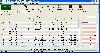 Allows you to connect your hand held Global Positioning System (GPS) unit to your computer, download your waypoints, and plot them in AutoCAD or export them in .dxf Also plots the points on free public domain Aerial photos and topo maps. Works on most Garmin and Magellan GPS units, and AutoCAD...
Platforms: Windows
| License: Shareware | Cost: $345.00 USD | Size: 9.9 MB | Download (543): GPS2CAD Download |
Released: July 07, 2004
|
Added: October 14, 2006 | Visits: 2.717
 MagicMap is a software for extracting color layers from scanned images - topo maps and logos.
Platforms: Windows
| License: Demo | Cost: $95.00 USD | Size: 3.38 MB | Download (353): MagicMap Download |
Released: March 01, 2010
|
Added: April 22, 2010 | Visits: 2.518
 Mapyx Quo is an intuitive, easy to learn and, surprisingly simple-to-use digital mapping program which enables you to connect your GPS to your PC and manage all your waypoints, routes and tracks. View information such as elevation, distance, speed, ETA and many more. Quo supports numerous...
Platforms: Windows, Windows CE
| License: Freeware | Size: 44.95 MB | Download (7377): Mapyx Quo Download |
Released: July 01, 2012
|
Added: July 01, 2012 | Visits: 755
 Atom GPS freeware easily geotags your photos directly from your GPS device or track log. By simply connecting your GPS Device to Atom GPS and selecting your photos you can add their geolocation in one click. This action allows you to write the geolocation data to your photos exifs (information...
Platforms: Windows
| License: Freeware | Size: 7.58 MB | Download (430): ATOM GPS Download |
Released: September 02, 2012
|
Added: September 02, 2012 | Visits: 640
Develop precise, efficient, and reliable GPS software in record time with this multithreaded component for desktop and mobile devices, including PocketPC, Windows CE, Tablet PC, Smartphone and now Windows Mobile! Over fifty classes in one lightweight assembly give you unparalleled features while...
Platforms: Windows, Pocket PC, Handheld/Mobile Other
| License: Shareware | Cost: $279.00 USD | Size: 10.34 MB | Download (51): GPS.NET Download |
Released: November 17, 2009
|
Added: April 17, 2010 | Visits: 2.524
 CopanMobile for Pocket PC is a very functional and easy-to-use geomatics engineering tool for computing and managing plane surveying and mapping coordinates.
It does numerous coordinate geometry (COGO) calculations, processes and adjusts raw field survey data, computes and adjusts map...
CopanMobile for Pocket PC is a very functional and easy-to-use geomatics engineering tool for computing and managing plane surveying and mapping coordinates.
It does numerous coordinate geometry (COGO) calculations, processes and adjusts raw field survey data, computes and adjusts map...
Platforms: Pocket PC, Windows
| License: Freeware | Size: 662.68 KB | Download (1153): CopanMobile for PocketPC Download |
Released: August 26, 2012
|
Added: August 26, 2012 | Visits: 612
The Garmin Phase Output protocol gives software developers the ability to upload and download data from Garmin devices. The Garmin Phase Output plug-in for GPS.NET makes working with Garmin devices easy by handing all of the complicated device communications for you. Upload and download...
Platforms: Windows
| License: Shareware | Cost: $39.00 USD | Size: 4.64 MB | Download (47): Garmin Phase Output Plug-In for GPS.NET Download |
Added: January 25, 2010 | Visits: 857
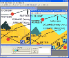
GPSy is a sophisticated Macintosh GPS communications and GIS mapping program. GPSy connects your Macintosh to a broad range of Global Positioning System (GPS) navigational units and has advanced mapping, logging, and data transfer features. GPSy has extensive support for USGS DRG topo maps,...
Platforms: Mac
| License: Demo | Cost: $0.00 USD | Download (104): GPSy Download |
Released: November 01, 2011
|
Added: November 30, 2011 | Visits: 1.142
 Global Mapper is more than just a utility; it has built in functionality for distance and area calculations, raster blending, feathering, spectral analysis and contrast adjustment, elevation querying, line of sight calculations, cut-and-fill volume calculations, as well as advanced capabilities...
Platforms: Windows, Other
| License: Shareware | Cost: $399.00 USD | Size: 11.24 MB | Download (110): Create Better Maps with Global Mapper 13 Download |
Released: January 30, 2013
|
Added: January 30, 2013 | Visits: 801
 GSM Tracker software to transform your GSM into a GPS device! * Know where you are * Share your location along the way * Stay connected with people you care about Livecontacts is a GPS enabled service that brings you an array of features like: GPS-enabled maps to plot your location as well as a...
Platforms: RIM
| License: Freeware | Size: 1024 B | Download (55): Livecontacts LC Mobile for BlackBerry Download |
Released: August 23, 2012
|
Added: August 23, 2012 | Visits: 569
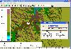
ExpertGPS is the ultimate mapping software for Garmin, Magellan, and Lowrance GPS owners. ExpertGPS displays your waypoints, routes, and tracks on USGS topo maps and aerial photos.
Using the powerful mapping tools in ExpertGPS, you can draw your route directly on a map, search for nearby...
Platforms: Windows
| License: Shareware | Cost: $74.95 USD | Size: 9.1 MB | Download (441): ExpertGPS Download |
Released: July 06, 2012
|
Added: July 06, 2012 | Visits: 632
 Softmio PDF Converter creates PDF documents from any application simply by printing them. It allows you to print as PDF: charts, drawings, tables, emails, text documents, spreadsheets, calendars, maps, photos, photo albums, web pages, Wikipedia articles or whatever other document or file can...
Platforms: Windows
| License: Freeware | Size: 8.06 MB | Download (53): Softmio PDF Converter Download |
Released: July 01, 2012
|
Added: July 01, 2012 | Visits: 509
Topos US is an app that provides access to download and view high resolution USGS topographic maps for the United States.
REGARDING MAP DATES:
You will often see a date on a downloaded map that seems pretty old. This is the date of last physical survey. This could be a long time ago. Often...
Platforms: Mac
| License: Commercial | Cost: $2.99 USD | Size: 716.8 KB | Download (49): Topos US Download |
Released: June 13, 2012
|
Added: June 13, 2012 | Visits: 726
 View maps of Earth and other planets with PrettyMap! See current day and night regions, learn geography by taking the quiz, enjoy 3D elevation surfaces, measure distances between locations and create your own maps with special places! PrettyMap lets you view vector and raster maps and images...
Platforms: Windows, Pocket PC
| License: Shareware | Cost: $19.95 USD | Size: 4.02 MB | Download (56): PrettyMap - World Atlas and Maps, GPS Download |
Added: February 15, 2010 | Visits: 2.247
GPS Tracker project allows someone to track a GPS enabled cell phone using Google maps. For this project I used a Motorola i355 cell phone on the Sprint/Nextel network. You need to have a data plan so that you can make updates to your website from the cellphone. Please read the ReadMe.txt file...
Platforms: *nix
| License: Freeware | Download (203): GPS Tracker Download |
Released: June 20, 2012
|
Added: June 20, 2012 | Visits: 610
Free Satellite Maps is a free tool from Google which offers a satellite mapping service worldwide.These are accompanied by a street service, a route planner and information about business in almost all countries.In this way we can fly the world from satellite view or in birds eye.The level of...
Platforms: Windows
| License: Freeware | Size: 612 KB | Download (47): Free Satellite Maps Download |
Added: May 10, 2013 | Visits: 1.088
This project allows someone to track a GPS enabled cell phone using Google maps.For this project it is used a Motorola i355 cell phone on the Sprint/Nextel network. You need to have a data plan so that you can make updates to your website from the cellphone. Project includes J2ME cell phone...
Platforms: Windows, Mac, *nix, PHP, BSD Solaris
| License: Freeware | Download (81): GPS Tracker Download |
Released: November 10, 2007
|
Added: November 20, 2007 | Visits: 6.091
 Geocode digital images with latitude, longitude, altitude, and direction information. RoboGEO stamps this information onto the actual photo or writes it to the EXIF headers, allowing you to permanently geotag and link your photos to the GPS coordinates. All writing to the EXIF and IPTC headers...
Platforms: Windows
| License: Demo | Cost: $39.95 USD | Size: 8.28 MB | Download (1179): RoboGEO Download |
Added: August 27, 2008 | Visits: 1.089
USAPhotoMaps downloads aerial photo and topo map data from Microsoft's free TerraServer Web site, saves it on your hard drive, and creates seamless maps from it. You can - Scroll and zoom, See the latitude/longitude, Add waypoints, routes, and text, Jump to any waypoint or latitude/longitude in...
Platforms: Windows
| License: Freeware | Size: 314 KB | Download (505): USAPhotoMaps Download |
Released: August 15, 2013
|
Added: August 20, 2013 | Visits: 972
 The GPS Generator PRO application is designed for providing assitance in developing, testing and debugging programs and equipment working with the NMEA-0183 protocol. This application can also be used for learning and testing navigation applications and equipment before purchasing.
GPS Generator...
The GPS Generator PRO application is designed for providing assitance in developing, testing and debugging programs and equipment working with the NMEA-0183 protocol. This application can also be used for learning and testing navigation applications and equipment before purchasing.
GPS Generator...
Platforms: Windows, Other
| License: Shareware | Cost: $84.99 USD | Size: 4.3 MB | Download (994): GPS Generator PRO Download |