


Plotting Map Coordinates freeware
Plotting Map Coordinates
Released: November 05, 2012
|
Added: November 05, 2012 | Visits: 375
 At the current state, opengeodb provide geo coordinates and several other data (city name, zip) mainly for the german speaking area.
Platforms: Windows, Mac, Linux
At the current state, opengeodb provide geo coordinates and several other data (city name, zip) mainly for the german speaking area.
Platforms: Windows, Mac, Linux
| License: Freeware | Size: 2.82 MB | Download (48): open geo coordinates database Download |
Released: November 15, 2012
|
Added: November 15, 2012 | Visits: 391
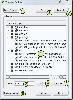
 Periscope is a 3D plotting library written in C++ on top of VTK. It provides an abstract interface for creating 3D plots.
Platforms: Windows, Mac, BSD, Linux
Periscope is a 3D plotting library written in C++ on top of VTK. It provides an abstract interface for creating 3D plots.
Platforms: Windows, Mac, BSD, Linux
| License: Freeware | Size: 369.29 KB | Download (58): Periscope 3D Plotting Library Download |
Released: July 10, 2012
|
Added: July 10, 2012 | Visits: 424
 Pyllar is a 3D plotting library for the Python programming language. It uses the Visualization Toolkit (VTK) and PyNum library provide high quality 3D plots for science and engineering.
Platforms: Windows, Mac, Linux
Pyllar is a 3D plotting library for the Python programming language. It uses the Visualization Toolkit (VTK) and PyNum library provide high quality 3D plots for science and engineering.
Platforms: Windows, Mac, Linux
| License: Freeware | Size: 490.86 KB | Download (48): Pyllar Plotting Library Download |
Released: December 08, 2012
|
Added: December 08, 2012 | Visits: 406
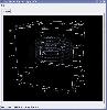
 QGis Python Plugin to create named map themes to switch the visibility of all layers belonging to theme.
Experimental working prototype with functionality to include in future version of QGIS.
Platforms: Windows, Mac, Linux
QGis Python Plugin to create named map themes to switch the visibility of all layers belonging to theme.
Experimental working prototype with functionality to include in future version of QGIS.
Platforms: Windows, Mac, Linux
| License: Freeware | Size: 94.26 KB | Download (43): QGis Map Themes Builder Plugin Download |
Released: October 16, 2012
|
Added: October 16, 2012 | Visits: 414
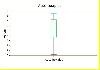 The SVG_plot C++ library allows, with a few lines of C++ code, to add plotting of data, held in STL containers like vector and map, output as SVG files that can be viewed by all modern browers.
1D, 2D and Boxplots can be produced, and there are a myriad of options to control appearance.
The...
Platforms: Windows, Mac, Linux
The SVG_plot C++ library allows, with a few lines of C++ code, to add plotting of data, held in STL containers like vector and map, output as SVG files that can be viewed by all modern browers.
1D, 2D and Boxplots can be produced, and there are a myriad of options to control appearance.
The...
Platforms: Windows, Mac, Linux
| License: Freeware | Size: 6.35 MB | Download (49): SVG_plot Download |
Released: June 12, 2012
|
Added: June 12, 2012 | Visits: 610
Implementation of an OGC Web Map Service, primarily for serving images dynamically generated from NetCDF data files (although other file formats can also be handled). Also an AJAX web mapping interface based on OpenLayers.
Platforms: Windows, Mac, Linux
| License: Freeware | Size: 24.57 MB | Download (49): Web Map Service for NetCDF data Download |
Released: September 18, 2012
|
Added: September 18, 2012 | Visits: 394
 This is a tool that helps map authors for the game Battle for Wesnoth to create symmetric maps.
Platforms: Windows, Mac, Linux
This is a tool that helps map authors for the game Battle for Wesnoth to create symmetric maps.
Platforms: Windows, Mac, Linux
| License: Freeware | Size: 50.04 KB | Download (45): Wesnoth Map Symmetrizer Download |
Released: June 13, 2012
|
Added: June 13, 2012 | Visits: 597
Yama - Yet Another Map ApplicationShows GPS map on PC and handheld devices
Platforms: Windows, Mac, Linux
| License: Freeware | Size: 984.19 KB | Download (44): Yet Another Map Application Download |
Released: July 10, 2012
|
Added: July 10, 2012 | Visits: 747
 with Zip2Map, one can find the geo map of any zip code(now U.S. only). finding the zip code, returns the Map of the location with its name and state name. Google Maps api has been used with PHP-MySql and lots of Ajax to make it a real WEB 2.0 Application
Platforms: Windows, Mac, Linux
with Zip2Map, one can find the geo map of any zip code(now U.S. only). finding the zip code, returns the Map of the location with its name and state name. Google Maps api has been used with PHP-MySql and lots of Ajax to make it a real WEB 2.0 Application
Platforms: Windows, Mac, Linux
| License: Freeware | Size: 678.94 KB | Download (55): Zip2Map, map your zip code Download |
Added: May 10, 2013 | Visits: 420
Time Map supports personal and global categories. Entries and categories can be color coded and are reported via the Simile Timeline API interface. The module can integrate with Colorpicker to replace the text boxes for manually inputing the hex color values.InstallationUnpack in your modules...
Platforms: Windows, Mac, *nix, PHP, BSD Solaris
| License: Freeware | Download (56): Time Map 5.x-1.1 Download |
Added: April 26, 2013 | Visits: 699
It enables the simple addition of mouseover highlighting of hotspots to HTML image maps without requiring the editing of theme files or knowledge of javascript/jquery.In order to map an image a class="jq_maphilight" needs to be added to the img tag.InstallationUnpack in your modules folder...
Platforms: BSD Solaris
| License: Freeware | Download (55): jQuery Map Hilight 6.x--beta1 / 5.x-1.x-dev Download |
Added: May 10, 2013 | Visits: 493
The location to search near must be given as a lat/long pair or postcode (if Location module is enabled).Paths in cck_maps (where a map has more than one marker) are determined with an algorithm that finds the two closest points first, which form the first part of the path, then progressively...
Platforms: Windows, Mac, *nix, PHP, BSD Solaris
| License: Freeware | Download (58): Map Search 5.x-1.x-dev Download |
Added: April 17, 2013 | Visits: 645
It enables the simple addition of mouseover highlighting of hotspots to HTML image maps without requiring the editing of theme files or knowledge of javascript/jquery.In order to map an image a class="jq_maphilight" needs to be added to the img tag.InstallationUnpack in your modules folder...
Platforms: BSD Solaris
| License: Freeware | Download (57): jQuery Map Hilight 6.x--beta1 / 5.x-1.x-dev Download |
Added: January 30, 2013 | Visits: 658
It enables the simple addition of mouseover highlighting of hotspots to HTML image maps without requiring the editing of theme files or knowledge of javascript/jquery.In order to map an image a class="jq_maphilight" needs to be added to the img tag.InstallationUnpack in your modules folder...
Platforms: BSD Solaris
| License: Freeware | Download (55): jQuery Map Hilight 6.x--beta1 / 5.x-1.x-dev Download |
Added: May 10, 2013 | Visits: 539
map:catalog is a infoware application consisting in a GUI (front-end) and Content Management System for storage of projects, offices locations, etc; It is CSS/PHP/database powered. The GUI is based on the Dominican Republic map, but can be adapted for any country map layout.
Platforms: Windows, Mac, *nix, PHP, BSD Solaris
| License: Freeware | Download (52): map:catalog Download |
Added: May 10, 2013 | Visits: 505
Map-Fu is a full-featured web mapping interface written using PHP/Javascript that can be modified and used as part of a custom web mapping application. It is designed to function as part of an open source mapping stack including UMN Mapserver.
Platforms: Windows, Mac, *nix, PHP, BSD Solaris
| License: Freeware | Download (58): Map-Fu Download |
Added: June 25, 2013 | Visits: 583
1> Log MAP decoder for RSC and NSC convolutional codes2> Based on Lalit Bahl's original BCJR algorithm and its logarithmic version (Hanzo & Woodard).3> Test-bench code is also included.4> *** PLEASE SUBMIT A RATING ***. Email me with any Qs
Platforms: Matlab
| License: Freeware | Size: 10 KB | Download (55): Log MAP decoder Download |
Added: June 15, 2013 | Visits: 334
This toolbox contains a satellite tracker MSatTrack. You can input orbital parameters defined by yourself or existing ones (included). The tracking is done in 3D and the resulting grountracks are then plotted on a 2D map after the simulation is done. Several satellites can be simulated...
Platforms: Matlab
| License: Freeware | Size: 358.4 KB | Download (49): Spacecraft Engineering Toolbox Download |
Added: September 11, 2013 | Visits: 518
Convert ECI (CIS, Epoch J2000.0) Coordinates to WGS 84 (CTS, ECEF) Coordinates. This function has been vectorized for speed.Example Function Call:>> [r_ECEF v_ECEF] = ECItoECEF(JD,r_ECI,v_ECI);Where:JD is the Julian Date vector [1 x N] (units are in days)r_ECI is the position vector [3 x N] (any...
Platforms: Matlab
| License: Freeware | Size: 10 KB | Download (46): Convert ECI to ECEF Coordinates Download |
Added: July 26, 2013 | Visits: 473
The 2-column vector contains cities' coordinates. The algorithm generates the optimal path to visit all the cities exactly once, and return to the starting city.The algorithm has its limitations, and based on the cities' distribution on the map it may or may not give the optimal solution.It...
Platforms: Matlab
| License: Freeware | Size: 10 KB | Download (44): Nearest Neighbor algorithm for the Travelling Salesman Problem Download |