


Maps Gps Navigacion Balkan freeware
Maps Gps Navigacion Balkan
Added: August 27, 2008 | Visits: 1.088
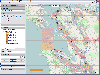
 USAPhotoMaps downloads aerial photo and topo map data from Microsoft's free TerraServer Web site, saves it on your hard drive, and creates seamless maps from it. You can - Scroll and zoom, See the latitude/longitude, Add waypoints, routes, and text, Jump to any waypoint or latitude/longitude in...
Platforms: Windows
| License: Freeware | Size: 314 KB | Download (505): USAPhotoMaps Download |
Released: November 10, 2012
|
Added: November 10, 2012 | Visits: 708
 Have a GPS and a laptop? Use this to find your way. Make patterns or a trail to share with others. When the application starts, you may pick your area of operations - be it North America, South America, Europe and Asia, or Australia. Your quadrant is determined by where you are in relation to the...
Platforms: Windows
| License: Freeware | Size: 4.56 MB | Download (503): LAS GPS Monitor LT Download |
Released: November 07, 2012
|
Added: November 07, 2012 | Visits: 620
 With this tool you can add GPS coordinates to vCards - electronic business cards - that you have previously exported from e. g. Microsoft Outlook. Therefore the tool uses the address data contained within the vCards and adds the exact GPS position on that basis to the vCard. This way you can use...
Platforms: Windows
| License: Freeware | Size: 1.47 MB | Download (503): GPS to vCard Download |
Released: November 16, 2012
|
Added: November 16, 2012 | Visits: 396
A geotagging application with a convenient GPS track library. GPS tracks can be downloaded from most of the common GPS loggers, such as: Wintec WBT-201, Holux M-241 and GPSport 245, Columbus V-900, Gisteq Phototrackr and Phototrackr Lite, iBlue 747 and Sony GPS CS-1 and CS-3. The new...
Platforms: Mac
| License: Freeware | Size: 68 MB | Download (501): myTracks for Mac OS Download |
Released: October 11, 2012
|
Added: October 11, 2012 | Visits: 600
QLandkarte GT is a handy, easy to use program specially designed to offer users a ultimate outdoor aficionado's tool.
This application offers support for GPS maps in GeoTiff format as well as Garmin's img vector map format.
for WindowsXP, Vista, 7
Platforms: Windows, Windows Vista, 7
| License: Freeware | Download (498): QLandkarte GT Download |
Released: September 07, 2012
|
Added: September 07, 2012 | Visits: 681
 GPS Converter will convert GPS coordinates between three different formats: 34.26965, -116.76783; N 34° 16.179', W 116° 46.07'; and N 34° 16' 10.74", W 116° 46' 4.2". Will map the results in Google Maps.
Platforms: Windows
| License: Freeware | Size: 1.14 MB | Download (491): GPS Converter Download |
Released: January 27, 2013
|
Added: January 27, 2013 | Visits: 1.104
 CMC Multimedia Sistem SRL ofera: Sisteme de Monitorizare Vehicule si Localizare prin GPS, Receptoare de ultima generatie GPS, Navigatie prin Sisteme GPS, Sisteme Urmarire GPS Auto, Abonamente GPS si Sisteme de Urmarire a Masinilor, GPS Tracking, Sisteme Navigatie Romania si International,...
Platforms: Windows, Mac, Unix, Linux, Palm OS 6.0, Pocket PC, RIM, Symbian, Handheld/Mobile Other, OpenVMS, Netware, BEOS, Java
| License: Freeware | Size: 974 KB | Download (476): Sisteme de Localizare, Monitorizare GPS Download |
Released: October 23, 2012
|
Added: October 23, 2012 | Visits: 654
GPS Utility is an easy-to-use application that provides management and manipulation of GPS information. You can use it to transfer data to/from a GPS receiver and store the data in PC files in one of several text formats.
The program converts between different map datums and many coordinate...
Platforms: Windows
| License: Freeware | Size: 1.87 MB | Download (469): GPS Utility Download |
Released: July 16, 2012
|
Added: July 16, 2012 | Visits: 554
 Midway Modders Mappack 1 - five new massive multiplayer maps for Battlestations Midway Indian Ocean Raid Tokyo Express Super Steel Mosters Ironbottom Sound Operation Ten-Go (sinking the Yamato) 100% compatibility with original version of Battlestations Midway. Just download it and install...
Platforms: Mac
| License: Freeware | Size: 199.97 MB | Download (463): Battlestations Midway Modders Mappack 1 (MacOS) Download |
Released: September 01, 2012
|
Added: September 01, 2012 | Visits: 640
 Midway Modders Mappack 1 - five new massive multiplayer maps for Battlestations Midway Indian Ocean Raid Tokyo Express Super Steel Mosters Ironbottom Sound Operation Ten-Go (sinking the Yamato) 100% compatibility with original version of Battlestations Midway. Just download it and install...
Platforms: Windows
| License: Freeware | Size: 197.58 MB | Download (456): Battlestations Midway Modders Mappack 1 (PC Win) Download |
Released: June 04, 2012
|
Added: June 04, 2012 | Visits: 473
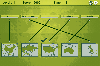 In this game there will be some country names and some maps of countries. Your task is to match the country names with the correct maps. You match them by using the mouse to draw a line to connect the dots of the country names and the maps. There are a total of 5 levels and each level will be...
Platforms: Windows
| License: Freeware | Size: 262 KB | Download (451): Mapping Maps Download |
Released: June 27, 2012
|
Added: June 27, 2012 | Visits: 395
import photos from gps cameras with automatic renaming based on gsp data
Platforms: Windows
| License: Freeware | Size: 6.53 MB | Download (451): sc.importer Download |
Released: September 04, 2012
|
Added: September 04, 2012 | Visits: 752
 Mobile Atlas Creator (formerly known as TrekBuddy Atlas Creator) is an open source (GPL) program which creates offline atlases for GPS handhelds and cell phone applications like TrekBuddy, AndNav and other Android and WindowsCE based applications.
For the full list of supported applications...
Mobile Atlas Creator (formerly known as TrekBuddy Atlas Creator) is an open source (GPL) program which creates offline atlases for GPS handhelds and cell phone applications like TrekBuddy, AndNav and other Android and WindowsCE based applications.
For the full list of supported applications...
Platforms: Mac
| License: Freeware | Size: 1.6 MB | Download (448): Mobile Atlas Creator for Mac OS X Download |
Released: July 01, 2012
|
Added: July 01, 2012 | Visits: 755
 Atom GPS freeware easily geotags your photos directly from your GPS device or track log. By simply connecting your GPS Device to Atom GPS and selecting your photos you can add their geolocation in one click. This action allows you to write the geolocation data to your photos exifs (information...
Platforms: Windows
| License: Freeware | Size: 7.58 MB | Download (430): ATOM GPS Download |
Released: June 03, 2012
|
Added: June 03, 2012 | Visits: 726
The Genome Positioning System (GPS) is a software tool to study protein-DNA interaction using ChIP-Seq data. GPS builds a probabilistic mixture model to predict the most likely positions of binding events at single-base resolution.
GPS is a Java software, so it runs on multiple platforms,...
Platforms: Windows
| License: Freeware | Download (430): GPS Download |
Released: June 20, 2012
|
Added: June 20, 2012 | Visits: 782
GPX and TCX file welder is a small, easy to use application specially designed to help you substitute the missing GPS information in Garmin TCX files when devices lacking a GPS receiver are used to collect training data (Garmin FR 60, heartrate and pedometer only).
This application is also...
Platforms: Windows
| License: Freeware | Download (425): GPX and TCX file welder Download |
Released: June 06, 2012
|
Added: June 06, 2012 | Visits: 394
Geotag is an easy to use application that allows you to match date / time information from photos with location information from a GPS unit or from a map.
The external maps might be necessary in order to perform fine-tune locations.
for WindowsAll
Platforms: Windows
| License: Freeware | Download (422): Geotag Download |
Released: July 09, 2012
|
Added: July 09, 2012 | Visits: 540
 Automatically extract from a geotagged image’s metadata, and then visually imprint (stamp), the GPS position, location description, altitude, date, date and time, or any combination of these or any other file metadata, onto a photo with no loss in image quality. It is a lossless JPEG process...
Platforms: Windows
| License: Freeware | Size: 11.9 MB | Download (406): GPStamper Download |
Added: August 21, 2008 | Visits: 2.676
Guitar chords maps. The game won't teach your kids to play guitar, but it'll get them off the couch, away from all that ear training zombie killing, and forcing them to concentrate chord guitar, guitar scales, guitar picking, Spanish guitar chords, electric guitar chords, Spanish guitar scales,...
Platforms: Windows, Mac
| License: Freeware | Size: 30 KB | Download (405): Guitar online maps Download |
Added: May 21, 2010 | Visits: 1.908
Geo::KML::PolyMap is a Perl module to generate KML/KMZ-format choropleth (shaded polygonal) maps viewable in Google Earth. SYNOPSIS use Geo::KML::PolyMap qw(generate_kml_file generate_kmz_file); # Clusters "Total Population" data for "Foobar City" in $entities into 5 bins; # renders using...
Platforms: *nix
| License: Freeware | Size: 11.26 KB | Download (399): Geo::KML::PolyMap Download |