


Geographical Atlas freeware
Geographical Atlas
Released: December 17, 2012
|
Added: December 17, 2012 | Visits: 787
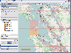
 Marble is a Virtual Globe and World Atlas that you can use to learn more about Earth: You can pan and zoom around and you can look up places and roads. A mouse click on a place label will provide the respective Wikipedia article. Of course it's also possible to measure distances between locations...
Platforms: Windows
Marble is a Virtual Globe and World Atlas that you can use to learn more about Earth: You can pan and zoom around and you can look up places and roads. A mouse click on a place label will provide the respective Wikipedia article. Of course it's also possible to measure distances between locations...
Platforms: Windows
| License: Freeware | Size: 16.5 MB | Download (683): Portable Marble Download |
Added: August 09, 2008 | Visits: 1.333
 Can you imagine being able to access all the information about any of more than 200 countries of the world with only one mouse click? Well, stop imagining because you can do it with Amiglobe 2002. Amiglobe 2002 is a database and large-scale world atlas that offers all the interesting data about...
Platforms: Windows
Can you imagine being able to access all the information about any of more than 200 countries of the world with only one mouse click? Well, stop imagining because you can do it with Amiglobe 2002. Amiglobe 2002 is a database and large-scale world atlas that offers all the interesting data about...
Platforms: Windows
| License: Freeware | Size: 7 KB | Download (313): Amiglobe Download |
Added: March 21, 2010 | Visits: 1.097
Atlas C++ is the standard implementation of the WorldForge Atlas protocol. WorldForge::Atlas-C++ is currently being developed in parallel with a stable branch, and the development code maintained separatly. The stable branch are numbered 0.4.x and implement the atlascpp-0.4 API, and the latest...
Platforms: *nix
| License: Freeware | Size: 225.28 KB | Download (102): WorldForge::Atlas-C++ Download |
Added: July 27, 2010 | Visits: 1.563
IP-Atlas tries to plot your location or any other host on the internet using the NetGeo data. It finds the latitude and longitude coordinates of the host and plots it on an image for you.It finds the latitude and longitude coordinates of the host and plots it on an image for you. You can try the...
Platforms: *nix
| License: Freeware | Size: 93.18 KB | Download (128): IP-Atlas Download |
Released: July 19, 2012
|
Added: July 19, 2012 | Visits: 834
 Mobile Atlas Creator (formerly known as TrekBuddy Atlas Creator) is an open source (GPL) program which creates offline atlases for GPS handhelds and cell phone applications like TrekBuddy, AndNav and other Android and WindowsCE based applications.
For the full list of supported applications...
Platforms: Windows
Mobile Atlas Creator (formerly known as TrekBuddy Atlas Creator) is an open source (GPL) program which creates offline atlases for GPS handhelds and cell phone applications like TrekBuddy, AndNav and other Android and WindowsCE based applications.
For the full list of supported applications...
Platforms: Windows
| License: Freeware | Size: 2 MB | Download (398): Mobile Atlas Creator Download |
Released: September 04, 2012
|
Added: September 04, 2012 | Visits: 754
 Mobile Atlas Creator (formerly known as TrekBuddy Atlas Creator) is an open source (GPL) program which creates offline atlases for GPS handhelds and cell phone applications like TrekBuddy, AndNav and other Android and WindowsCE based applications.
For the full list of supported applications...
Platforms: Mac
Mobile Atlas Creator (formerly known as TrekBuddy Atlas Creator) is an open source (GPL) program which creates offline atlases for GPS handhelds and cell phone applications like TrekBuddy, AndNav and other Android and WindowsCE based applications.
For the full list of supported applications...
Platforms: Mac
| License: Freeware | Size: 1.6 MB | Download (448): Mobile Atlas Creator for Mac OS X Download |
Released: August 23, 2012
|
Added: August 23, 2012 | Visits: 630
The Virtual Moon Atlas Pro allows you to explore and analyze the sophisticated natural satellite known as the Moon.
A complex but easy to use software and a 3D image database.
Platforms: Windows
| License: Freeware | Download (451): Virtual Moon Atlas Download |
Added: October 14, 2013 | Visits: 519
The Cardiac Atlas Project seeks to establish a structural and functional atlas of the heart. This project is dedicated to combine cardiac modeling and biophysical analysis methods with a structural database for the comprehensive mapping of heart structure and function.
Platforms: Mac
| License: Freeware | Size: 8.44 MB | Download (48): Cardiac Atlas Client Download |
Added: August 15, 2008 | Visits: 1.230
 England, Ireland, Scotland, and Wales at 6 miles/inch from Andrees magnificent 1899 Atlas, the finest atlas of the 19th century. One must have this atlas to understand pre-1974 traditional counties. Scanned at 300dpi - the beautiful color engravings make fine prints. A necessity for historians...
Platforms: Windows
England, Ireland, Scotland, and Wales at 6 miles/inch from Andrees magnificent 1899 Atlas, the finest atlas of the 19th century. One must have this atlas to understand pre-1974 traditional counties. Scanned at 300dpi - the beautiful color engravings make fine prints. A necessity for historians...
Platforms: Windows
| License: Freeware | Size: 32.31 MB | Download (568): Andree's Atlas Part 3 Download |
Added: August 26, 2008 | Visits: 1.043
Atlas is a program for architects and construction engineers. Atlas computes the resulting moments and reaction forces for a given beam with loads applied to it (single as well as distributed), using Cross' method. The program has a very easy interface. It lets you enter your data with the mouse,...
Platforms: Windows
| License: Freeware | Size: 625 KB | Download (581): Atlas Download |
Released: July 19, 2012
|
Added: July 19, 2012 | Visits: 521
"Atlas of Interventional Cardiology" is a preview version of CARDIO3®INVASIVE project – reference/learning tool for cardiologists, cardiac surgeons, internists, other physicians evaluating interventional images in cardiology.
Edited by Jaroslav Januska M.D. Hospital Podlesi a.s., Cardiac...
Platforms: Mac
| License: Freeware | Size: 819.2 KB | Download (51): CARDIO3® Atlas of Interventional Cardiology – Lite Download |
Added: September 15, 2013 | Visits: 3.563
Lord of the Rings Map is an atlas of Middle-Earth. What is does is to show an image of a map and provide the user with a list of places on that map. When you select a place the map will scroll to it. You can choose from different maps and from different lists. Included are translations of the...
Platforms: *nix
| License: Freeware | Size: 368.64 KB | Download (243): Lord of the Rings Map Download |
Added: January 25, 2010 | Visits: 717
This is a simple and fun widget to learn about the features of the lunar surface that are visible from Earth. The lunar atlas is an orthographic render created from data taken by the Lunar Orbiter Missions (NASA) and provided by the USGS Astrogeology Research Program. Right-click on the atlas to...
Platforms: Mac
| License: Freeware | Download (101): Moon Atlas Widget Download |
Added: May 10, 2013 | Visits: 569
Features : - Column resizing -The user can resize grid columns - Drag and drop row sorting - Drag elements between two grids - Rich client-side api for advanced features - You can make the grid look anyway you want just adjusting the css.Updates: - Grid has now embedded resources, no need to copy...
Platforms: Windows, ASP.NET,
| License: Freeware | Download (54): DataGrid Atlas Extender Control Download |
Added: August 18, 2013 | Visits: 486
Geotagmapper adds geographical identification metadata (latitude and longitude) to the HTML header.You only have to specify your address.Installation : 1. Copy complete folder to '/wp-content/plugins/' or upload from wordpress.org 2. Activate in Plugins menu 3. Enter your address in...
Platforms: PHP
| License: Freeware | Size: 174.08 KB | Download (45): Geotagmapper Download |
Added: April 19, 2013 | Visits: 513
Location Facets exposes geographical information associated with Drupal nodes as facets for the Faceted Search module. For its geographical information Location Facets relies on the Location module.
Platforms: PHP
| License: Freeware | Size: 10 KB | Download (47): Location Facets Download |
Added: September 18, 2013 | Visits: 198
Library that lets you get the user's geographical context without having to ask them
Platforms: Mac
| License: Freeware | Size: 10.24 KB | Download (40): DFGeoContext Download |
Added: November 25, 2013 | Visits: 399
GeoModelText is a tool that will assist an operator in adding detailed geographical information to XML-TEI files, and export the model created in XML.
Platforms: *nix
| License: Freeware | Size: 51.2 KB | Download (36): GeoModelText Download |
Released: January 05, 2006
|
Added: April 09, 2006 | Visits: 6.243
Timesheet Software Solutions.
Master your business with Atlas Timesheet and Project Manager 7.1 Real power comes from ATLAS Timesheet Software. Use it to streamline the entry, tracking, billing, and reporting of time and expense information throughout your organization.
Atlas Timesheet...
Platforms: DOS, OS/2, BeOS, Palm OS, Windows, Mac, *nix, Windows CE
| License: Freeware | Size: 31.46 MB | Download (681): Timesheet Software Solutions Download |
Released: February 24, 2008
|
Added: March 25, 2008 | Visits: 1.703
 SendEmails is the premier email marketing software. Design. Deliver. Track. Now e-mail marketing is easy as 1-2-3.
SendEmails is a high-performance newsletter software with advanced functions. The product features: ultra fast delivery which submits your newsletter in minutes, highest...
Platforms: Windows
SendEmails is the premier email marketing software. Design. Deliver. Track. Now e-mail marketing is easy as 1-2-3.
SendEmails is a high-performance newsletter software with advanced functions. The product features: ultra fast delivery which submits your newsletter in minutes, highest...
Platforms: Windows
| License: Freeware | Size: 5.46 MB | Download (175): SendEmails Free Edition Download |