


Quantum Gis software
Quantum Gis
Added: August 18, 2008 | Visits: 1.359
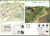 Genesis IV is a landscape database and graphics system particularly targeted at Professional GIS and Educational users. Create great graphics for your clients, enthuse and educate your students, or explore geographical data, GenesisIV is unique multifaceted software and much more than a simple...
Platforms: Windows
| License: Freeware | Size: 23.84 MB | Download (606): GenesisIV Download |
Added: August 03, 2008 | Visits: 526
 One of the world's highly accepted game for all ages. An addictive game whether you're on a trip, past time or for learning purposes. Play against your AI opponent or play it on your own. This product has it all.
Platforms: Palm OS
| License: Shareware | Cost: $9.00 USD | Size: 916 KB | Download (487): Chess Quantum Download |
Added: August 12, 2008 | Visits: 954
NewCyber3D provides full source code CDs covering a wide range of topics relevant to OpenGL GIS, terrain, stereo display, image processing and visualization. Each CD includes the entire OpenGL program and demonstrations with full source codes (including library source codes), project files,...
Platforms: Windows
| License: Freeware | Download (549): NewCyber3D Download |
Added: August 07, 2008 | Visits: 2.160
QCADesigner is a CAD tool for quantum-dot cellular automata (QCA) circuits. The powerful CAD features and simulation engines allow for rapid design, layout, and simulation of QCA circuits and systems. QCADesigner has most of the standard computer aided design features required for the advanced...
Platforms: Windows, *nix
| License: Freeware | Size: 2.6 MB | Download (1031): QCADesigner Download |
Added: January 14, 2010 | Visits: 1.205
OGDI is the Open Geographic Datastore Interface. OGDI is an application programming interface (API) that uses a standardized access methods to work in conjunction with GIS software packages (the application) and various geospatial data products. OGDI uses a client/server architecture to...
Platforms: *nix
| License: Freeware | Size: 911.36 KB | Download (91): Open Geographic Datastore Interface Download |
Added: February 05, 2010 | Visits: 772
Geotools is an open source Java GIS toolkit for developing standards compliant solutions. GeoTools project provides an implementation of Open Geospatial Consortium (OGC) specifications as they are developed. Geotools maintains an open development process, with public collaboration on new ideas...
Platforms: *nix
| License: Freeware | Size: 26 MB | Download (113): GeoTools Download |
Added: January 25, 2010 | Visits: 931
GrassPro is based on the free, open-source product "GRASS 6.0.1 GIS." It offers offers a host of ready-to-use GIS software and utilities, including: MapServer for publishing dynamic, navigable maps with layers over the Internet; PostGIS which enables spatial, geographic support for the included...
Platforms: Mac
| License: Demo | Cost: $0.00 USD | Download (109): GrassPro Download |
Released: May 24, 2010
|
Added: July 12, 2010 | Visits: 963
 Aspose.Flash is a non-graphical .NET Flash management component allowing developers to dynamically generate and edit Flash® content directly from .NET applications. It provides support for Flash v8, Flash v9, Flash Lite and ActionScript allowing you to create, parse and modify flash files. Using...
Platforms: Windows
| License: Shareware | Cost: $399.00 USD | Size: 15.3 MB | Download (98): Aspose.Flash for .NET Download |
Released: March 29, 2020
|
Added: April 06, 2020 | Visits: 2.727
GeoDLL is a Geodetic Development Kit / Geodetic Function Library with worldwide 2D and 3D Coordinate Transformation, Datum Shift, Meridian Convergence and Extra Parameter with highest accuracy. Furthermore: Helmert and Molodensky Parameters, NTv2, HARN, INSPIRE, EPSG, Digital Elevation Model...
Platforms: Windows, Windows 8, Windows 7, Windows Server
| License: Shareware | Cost: $560.00 USD | Size: 5.23 MB | Download (301): GeoDLL Download |
Released: March 06, 2011
|
Added: March 10, 2011 | Visits: 985
 Total CAD View Server is a reliable full featured CAD viewer. An ActiveX control allows you viewing and printing.
CAD drawings via your Internet Explorer browser. The control is very small in size to provide fast downloading. No other additional software is required. Giving access to any...
Total CAD View Server is a reliable full featured CAD viewer. An ActiveX control allows you viewing and printing.
CAD drawings via your Internet Explorer browser. The control is very small in size to provide fast downloading. No other additional software is required. Giving access to any...
Platforms: Windows
| License: Shareware | Cost: $295.00 USD | Size: 2.82 MB | Download (164): Total GIS View Server Download |
Released: April 05, 2011
|
Added: April 11, 2011 | Visits: 1.741
 CtrlCAD is a 2D source code cad for C++.It is the starting point to build your own customized drawing applications. The library is furnished in source code formats for c++
More then 1000 functions,well documented with a lot of examples.
CtrlCAD features:
- Supported formats: AutoCAD DWG/...
CtrlCAD is a 2D source code cad for C++.It is the starting point to build your own customized drawing applications. The library is furnished in source code formats for c++
More then 1000 functions,well documented with a lot of examples.
CtrlCAD features:
- Supported formats: AutoCAD DWG/...
Platforms: Windows
| License: Shareware | Cost: $1800.00 USD | Size: 2.3 MB | Download (152): CtrlCAD source code C++ Download |
Released: June 13, 2010
|
Added: September 08, 2011 | Visits: 930
 Silverlight Map Viewer is a .NET native GIS viewer control which allows developers to create interactive mapping application on the web browser. Packed with powerful AJAX interactive, simple API that makes coding easy. It is compatible with Silveright 4.0 and Visual Studio 2010. It includes many...
Platforms: Windows
| License: Shareware | Cost: $199.00 USD | Size: 4.96 MB | Download (758): SwiftGIS Silverlight MapViewer Download |
Released: November 16, 2012
|
Added: November 16, 2012 | Visits: 492
 The goal of VTP is to foster the creation of tools for easily constructing any part of the real world in interactive, 3D digital form.
This goal will require a synergetic convergence of the fields of CAD, GIS, visual simulation, surveying and remote sensing. VTP gathers information and tracks...
The goal of VTP is to foster the creation of tools for easily constructing any part of the real world in interactive, 3D digital form.
This goal will require a synergetic convergence of the fields of CAD, GIS, visual simulation, surveying and remote sensing. VTP gathers information and tracks...
Platforms: Mac, Linux
| License: Freeware | Size: 2.2 MB | Download (492): Virtual Terrain Project for Mac OS X and Linux Download |
Released: November 04, 2012
|
Added: November 04, 2012 | Visits: 556
MOPlot is a handy visualization application specially designed for fast molecular orbitals plotting from the outputs of the Gaussian 03/98/94, Molcas, Gamess/US quantum chemical calculation packages. This Molecular Orbital Plotting Program will prove to be easy-to-use and very efficient.
MOPlot...
Platforms: Windows, XP
| License: Freeware | Download (478): MOPlot Download |
Released: October 22, 2012
|
Added: October 22, 2012 | Visits: 588
IrriPro is the only software that let you design an irrigation system only by drawing the elements: now it's possible, thanks to the INDO technology (Irrigation Network Data Object) developed by Irriworks, to draw the elements of a system (such as outlets, pipes, etc) and of a terrain, not only...
Platforms: Windows
| License: Freeware | Size: 161 MB | Download (467): IrriPro Download |
Released: July 14, 2012
|
Added: July 14, 2012 | Visits: 618
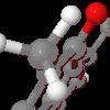 Jmol is an applet and Java based application designed to display various 3D chemical information.
Jmol's features include reading a variety of file types and output from quantum chemistry programs, and animation of multi-frame files and computed normal modes from quantum programs....
Jmol is an applet and Java based application designed to display various 3D chemical information.
Jmol's features include reading a variety of file types and output from quantum chemistry programs, and animation of multi-frame files and computed normal modes from quantum programs....
Platforms: Windows
| License: Freeware | Size: 14.8 MB | Download (407): Jmol Download |
Released: June 18, 2012
|
Added: June 18, 2012 | Visits: 476
 The goal of VTP is to foster the creation of tools for easily constructing any part of the real world in interactive, 3D digital form.
This goal will require a synergetic convergence of the fields of CAD, GIS, visual simulation, surveying and remote sensing. VTP gathers information and tracks...
The goal of VTP is to foster the creation of tools for easily constructing any part of the real world in interactive, 3D digital form.
This goal will require a synergetic convergence of the fields of CAD, GIS, visual simulation, surveying and remote sensing. VTP gathers information and tracks...
Platforms: Windows
| License: Freeware | Size: 1024 KB | Download (420): Virtual Terrain Project for Windows Download |
Released: October 16, 2012
|
Added: October 16, 2012 | Visits: 425
 Finally, high-quality map production software that works. MAPublisher® cartography software seamlessly integrates over 40 GIS tools into the Adobe Illustrator environment to help you create maps the way you want, how you want. Import the most widely used GIS data formats, including those from...
Platforms: Mac
| License: Shareware | Cost: $1399.00 USD | Size: 222.9 MB | Download (471): MAPublisher Download |
Released: August 16, 2012
|
Added: August 16, 2012 | Visits: 529
uDig is a user-friendly desktop Internet GIS, a core element in an internet aware Geographic Information System.
The application is an open source spatial data viewer / editor, that comes with a special emphasis on the OpenGIS standards for internet GIS, the Web Map Server and Web Feature Server...
Platforms: Windows
| License: Freeware | Download (439): uDig Download |
Released: November 14, 2012
|
Added: November 14, 2012 | Visits: 412
NTRU was specially designed as a public key cryptosystem that is thought to be unbreakable even with quantum computers.
Commonly used cryptosystems like RSA or ECC, on the other hand, will be broken if and when quantum computers become available. In addition, NTRU is significantly faster than...
Platforms: Windows
| License: Freeware | Download (419): NTRU Download |