


Polar Coordinate Geometry software
Polar Coordinate Geometry
Added: March 31, 2013 | Visits: 545
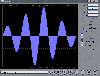
 Polar Parallel Coordinate Geometry (PPCG) plots standardardised time series data. Colour is used to demonstrate data through time; black being the oldest to white being the newest. 2 - 3 Std deviation warning/action limits are also highlighted by yellow/red respectively.
Platforms: Matlab
| License: Freeware | Size: 10 KB | Download (51): Polar Parallel Coordinate Geometry Download |
Added: September 22, 2010 | Visits: 1.575
GIS::Distance::Polar can do Polar coordinate flat-earth distance calculations. SYNOPSIS my $calc = GIS::Distance::Polar->new(); my $distance = $calc->distance( $lon1, $lat1 => $lon2, $lat2 ); Supposedly this is a formula to better calculate distances at the poles. While implimented, this...
Platforms: *nix
| License: Freeware | Size: 8.19 KB | Download (165): GIS::Distance::Polar Download |
Released: May 28, 2010
|
Added: June 04, 2010 | Visits: 2.699
 Copan for Windows desktop/netbook is a very functional and easy-to-use geomatics engineering tool for computing and managing plane land surveying and mapping coordinates.
It does numerous coordinate geometry (COGO) calculations, processes and adjusts raw field survey data, computes and...
Copan for Windows desktop/netbook is a very functional and easy-to-use geomatics engineering tool for computing and managing plane land surveying and mapping coordinates.
It does numerous coordinate geometry (COGO) calculations, processes and adjusts raw field survey data, computes and...
Platforms: Windows
| License: Freeware | Size: 5.28 MB | Download (824): Copan for Windows Download |
Released: November 17, 2009
|
Added: April 17, 2010 | Visits: 2.524
 CopanMobile for Pocket PC is a very functional and easy-to-use geomatics engineering tool for computing and managing plane surveying and mapping coordinates.
It does numerous coordinate geometry (COGO) calculations, processes and adjusts raw field survey data, computes and adjusts map...
CopanMobile for Pocket PC is a very functional and easy-to-use geomatics engineering tool for computing and managing plane surveying and mapping coordinates.
It does numerous coordinate geometry (COGO) calculations, processes and adjusts raw field survey data, computes and adjusts map...
Platforms: Pocket PC, Windows
| License: Freeware | Size: 662.68 KB | Download (1153): CopanMobile for PocketPC Download |
Released: January 10, 2012
|
Added: February 04, 2012 | Visits: 1.167
 Copan Pro -- for Windows 98, NT, 2000, ME, XP, Vista, or 7 -- is a very functional and easy-to-use desktop/netbook geomatics engineering tool for computing and managing plane land surveying and mapping coordinates, and drafting survey maps and plans.
It does numerous coordinate geometry...
Copan Pro -- for Windows 98, NT, 2000, ME, XP, Vista, or 7 -- is a very functional and easy-to-use desktop/netbook geomatics engineering tool for computing and managing plane land surveying and mapping coordinates, and drafting survey maps and plans.
It does numerous coordinate geometry...
Platforms: Windows
| License: Demo | Cost: $650.00 USD | Size: 8.78 MB | Download (126): Copan Pro Download |
Released: January 11, 2014
|
Added: January 26, 2014 | Visits: 662
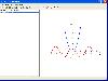
 This software utility can plot regular or parametric functions, in Cartesian or polar coordinate systems, and is capable to evaluate the roots, minimum and maximum points as well as the first derivative and the integral value of regular functions. Easy to use, ergonomic and intuitive interface,...
Platforms: Windows, Windows 7
| License: Shareware | Cost: $15.00 USD | Size: 1.18 MB | Download (72): WinDraw Download |
Released: December 22, 2011
|
Added: January 24, 2012 | Visits: 1.468
 Land surveyors and civil engineers:
o Calculate surveys and manage points, effortlessly
o Run Copan on Windows 2K/XP/Vista/7
o Use it forever and pay nothing
o Choose quadrant bearings or N/S azimuths, and gons or DMS
o Create point files quickly and easily
o Edit...
Land surveyors and civil engineers:
o Calculate surveys and manage points, effortlessly
o Run Copan on Windows 2K/XP/Vista/7
o Use it forever and pay nothing
o Choose quadrant bearings or N/S azimuths, and gons or DMS
o Create point files quickly and easily
o Edit...
Platforms: Windows
| License: Freeware | Size: 5.44 MB | Download (983): Copan Lite Download |
Released: August 23, 2012
|
Added: August 23, 2012 | Visits: 487
Copan is a very efficient and easy-to-use geomatics engineering tool for computing and managing plane survey coordinates. It does numerous coordinate geometry (COGO) calculations, processes and adjusts raw field survey data, computes and adjusts map traverse data, performs map checks, calculates...
Platforms: Windows
| License: Freeware | Download (450): Copan Download |
Added: October 18, 2006 | Visits: 5.607
Comprehensive tutorial and testing package covering core topics in Algebra, Trigonometry, Elementary Functions and other standard Precalculus material.
Java- and web-based math course includes theoretical concepts, hands-on examples featuring...
Platforms: Windows, *nix
| License: Demo | Cost: $55.00 USD | Size: 1.11 MB | Download (246): MathAid Precalculus Download |
Released: September 16, 2006
|
Added: February 10, 2007 | Visits: 6.234
 Equation grapher is an easy-to-use software for 2D function graphing. 2D function graphs can be plotted in Cartesian and polar coordinate systems .Equation grapher is an easy-to-use software for 2D function graphing. 2D function graphs can be plotted in Cartesian and polar coordinate systems...
Platforms: Windows
| License: Freeware | Size: 1.23 MB | Download (714): Equation Grapher Download |
Added: August 18, 2008 | Visits: 4.251
 Survey Plat Tools allows you to create professional survey or civil drawings with ease. Unlike the competition Survey Plat Tools is easy to use and understand. It is designed to be used with AutoCad 2002 through 2008. You will find it faster and easier to use than any other survey or engineering...
Platforms: Windows
| License: Shareware | Cost: $350.00 USD | Size: 2.7 MB | Download (626): Survey Plat Software and Cogo Software for AutoCad Download |
Added: November 26, 2010 | Visits: 993
Ympyris project is a circular falling blocks game. Ympyris is a falling blocks game that uses a circle instead of a rectangular grid. Ympyris is a game that combines the idea of Tetris to the polar coordinate system. In normal Tetris-clones you move the falling blocks left and right. In...
Platforms: *nix
| License: Freeware | Download (102): Ympyris Download |
Released: October 15, 2010
|
Added: November 13, 2010 | Visits: 1.259
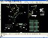
 Civil Survey AutoCAD Clone Software, no learning curve for AutoCAD users, Natively reads and writes AutoCAD DWG files, no need for conversion! Includes Data Colector File Import, COGO, Contours, DTM, Road Design, Sections and Profiles. low-cost alternative to otherwise high priced Land survey,...
Platforms: Windows
| License: Shareware | Cost: $999.00 USD | Size: 1.66 MB | Download (173): progeEARTH Land Development Suite Download |
Released: August 15, 2012
|
Added: August 15, 2012 | Visits: 518
Copan for Pocket PC is a very functional and easy-to-use geomatics engineering tool for computing and managing plane surveying and mapping coordinates.
It does numerous coordinate geometry (COGO) calculations, processes and adjusts raw field survey data, computes and adjusts map traverse data,...
| License: Freeware | Size: 662 KB | Download (45): Copan for PocketPC Download |
Released: December 19, 2012
|
Added: December 19, 2012 | Visits: 901
Copan for Mobile 6 is a very functional and easy-to-use geomatics engineering tool for computing and managing plane surveying and mapping coordinates.
It does numerous coordinate geometry (COGO) calculations, processes and adjusts raw field survey data, computes and adjusts map traverse data,...
Platforms: Windows
| License: Freeware | Size: 662 KB | Download (56): Copan for Mobile Download |
Released: November 07, 2012
|
Added: November 07, 2012 | Visits: 607
 Civil Survey AutoCAD Clone Software, no learning curve for AutoCAD users, Natively reads and writes AutoCAD DWG files, no need for conversion! Includes Data Colector File Import, COGO, Contours, DTM, Road Design, Sections and Profiles. low-cost alternative to otherwise high priced Land survey,...
Platforms: Windows
| License: Shareware | Cost: $1399.00 USD | Size: 157.11 MB | Download (62): progeEARTH 2009 Civil Survey Download |
Released: November 15, 2012
|
Added: November 15, 2012 | Visits: 509
CopanMobile for Palm OS is a very functional and easy-to-use geomatics engineering tool for computing and managing plane surveying and mapping coordinates. It does numerous coordinate geometry (COGO) calculations, processes and adjusts raw field survey data, computes and adjusts map traverse...
Platforms: Palm,OS
| License: Freeware | Size: 341 KB | Download (55): CopanMobile for PalmOS Download |
Released: June 03, 2016
|
Added: July 19, 2016 | Visits: 713
 Visual Calculus is an easy-to-use calculus grapher for Graphing limit, derivative function, integral, 3D vector, double integral, triple integral, series, ode etc. Which can create 2D, 2.5D and 3D function graphs, animations and table graphs. 2D Features: explicit, implicit, parametric, and in...
Platforms: Windows, Windows 7, Windows Server
| License: Demo | Cost: $60.00 USD | Size: 3.75 MB | Download (91): Visual Calculus Download |
Released: September 21, 2013
|
Added: November 10, 2013 | Visits: 737
 Visual Calculus is an easy-to-use calculus grapher for Graphing limit, derivative function, integral, 3D vector, double integral, triple integral, series, ode etc. Which can create 2D, 2.5D and 3D function graphs, animations and table graphs. 2D Features: explicit, implicit, parametric, and in...
Platforms: Windows, Windows 7, Windows Server
| License: Shareware | Cost: $60.00 USD | Size: 3.75 MB | Download (48): Visual Calculus For Academic Download |
Released: November 20, 2015
|
Added: April 20, 2016 | Visits: 3.088
 The Eye4Software Coordinate Calculator is an easy to use tool to perform map or GPS coordinate conversions. The software can be used to transform a single coordinate or a batch of coordinates read from a comma separated, database or ESRI shapefiles. The software is shipped with a MS Access...
Platforms: Windows, Windows 7
| License: Shareware | Cost: $119.00 USD | Size: 8.96 MB | Download (249): Eye4Software Coordinate Calculator Download |