


Ortophoto Maps software
Ortophoto Maps
Released: February 07, 2012
|
Added: February 26, 2012 | Visits: 1.139
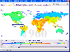 Free standalone software DataPult Desktop creates heat maps from your data quickly and efficiently.
Key features:
Direct data import from MS Excel with one click.
The ability to create animated maps of data over several years.
Interactive maps and diagrams.
39 map...
Free standalone software DataPult Desktop creates heat maps from your data quickly and efficiently.
Key features:
Direct data import from MS Excel with one click.
The ability to create animated maps of data over several years.
Interactive maps and diagrams.
39 map...
Platforms: Windows
| License: Freeware | Size: 20.96 MB | Download (95): DataPult Desktop Download |
Added: May 08, 2010 | Visits: 920
 TM::DM is a Perl module with Topic Maps, read-only TMDM layer. SYNOPSIS # somehow acquire a map (see TM and its subclasses) my $tm = .... # put a TMDM layer on top of it use TM::DM; my $tmdm = new TM::DM (map => $tm); # get the TMDM topic map item my $topicmap = $tmdm->topicmap; #...
Platforms: *nix
| License: Freeware | Size: 215.04 KB | Download (91): TM::DM Download |
Added: November 02, 2010 | Visits: 1.333
QUAKE 4 Quakemas Map Pack is a bonus collection for Christmas with maps for Quake 4. This Map Pack is compatible with QUAKE 4 1.0, and updates 1.0.4.0 and 1.0.5.0. This Map Pack consists of the file pak013.pk4 and contains the following multiplayer maps: Campgrounds Redux (q4dm9): With...
Platforms: *nix
| License: Freeware | Size: 16.4 MB | Download (85): QUAKE 4 Quakemas Map Download |
Added: May 10, 2013 | Visits: 1.089
This project allows someone to track a GPS enabled cell phone using Google maps.For this project it is used a Motorola i355 cell phone on the Sprint/Nextel network. You need to have a data plan so that you can make updates to your website from the cellphone. Project includes J2ME cell phone...
Platforms: Windows, Mac, *nix, PHP, BSD Solaris
| License: Freeware | Download (81): GPS Tracker Download |
Released: December 10, 2023
|
Added: December 19, 2023 | Visits: 249
 Google Maps Downloader is a tool that can automatically download the Google Maps images to your PC. It can download the small tiles and save them to your hard disk, including the normal maps, satellite maps, hybrid maps, terrain maps, customized google maps. After downloading, you can view the...
Platforms: Windows 8, Windows 7, Windows
| License: Shareware | Cost: $59.00 USD | Size: 30.6 MB | Download (70): Google Maps Downloader |
Released: May 23, 2020
|
Added: June 27, 2020 | Visits: 703
 Universal Maps Downloader is a tool that help you to get small tile images from Google Maps, Openstreetmap, Yandex Maps, The national map, Yahoo Maps, Mapquest, Gaode map, Tencent Maps, Baidu Maps, Tianditu, 360ditu, Arcgis Online Maps, OneMap for Singapore, Whereis for Australia, mapy.cz, Mappy,...
Platforms: Windows, Windows 8, Windows 7
| License: Shareware | Cost: $59.95 USD | Size: 8.85 MB | Download (67): Universal Maps Downloader |
Added: May 10, 2013 | Visits: 367
Hme application is a 2D program, used for creating, manipulating and viewing height maps. A height map is a 2D representation of a 3D terrain. Each 'color' represents a height. Things it can do: - Generate a random terrain. - Place a height, over the terrain (freehand lines). - Dig (escavate)...
Platforms: Windows, Mac, *nix, C/C++, BSD Solaris
| License: Freeware | Download (66): Hme Application Download |
Added: May 10, 2013 | Visits: 508
Features - provides an API to help other modules display Google Maps - defines a display plugin for Views - provides some default pages containing maps of nodes and users - defines a macro language and provides an interface for building macros ("[gmap|stuff]") so that users can put maps in their...
Platforms: Windows, Mac, *nix, PHP, BSD Solaris
| License: Freeware | Download (65): GMap Module Download |
Added: May 10, 2013 | Visits: 519
Tierra Internet Mapper is a set of PHP scripts working with MySQL, AT&T's WebDot and GraphViz software to dynamically build graphical maps of internet routes. This tool can be used to map out funnels in network traffic and organization of network.
Platforms: Windows, Mac, *nix, PHP, BSD Solaris
| License: Freeware | Download (61): Tierra Internet Mapper Download |
Added: May 10, 2013 | Visits: 521
phpWeatherMap is a set of php scripts to generate weather maps for (almost) every country in the world. Weather data is fetched from the official METAR Airport Weather at weather.noaa.gov. Currently there are more than 5000 weather stations in over 200 countries. You can easily download new maps...
Platforms: Windows, Mac, *nix, PHP, BSD Solaris
| License: Freeware | Download (61): phpWeatherMap Download |
Released: August 13, 2012
|
Added: August 13, 2012 | Visits: 600
Live Satellite Maps or Google maps is a web server mapping applications.Provides scrolling map images and satellite photos around the earth and even the route between different places.Since 6 October 2005, live satellite Maps is part of local Google.Google live satellite Map provides the ability...
Platforms: Windows
| License: Freeware | Size: 643 KB | Download (60): Live Satellite Maps Download |
Added: May 10, 2013 | Visits: 488
Printing sequences or maps containing non-ASCII strings results in escape sequences. This function uses the not-so-commonly-known "string_escape" codec to facilitate printing such sequences for quick-viewing.
Platforms: Windows, Mac, *nix, Python, BSD Solaris
| License: Freeware | Download (59): repr() of containers with non-ASCII strings Download |
Added: May 10, 2013 | Visits: 463
This php application allows you to easily record your travel destinations and display them with Google maps.It simply stores the trip points in a xml flat file (no SQL database needed). Each point can be included in many trips.
Platforms: Windows, Mac, *nix, PHP, BSD Solaris
| License: Freeware | Download (59): phpGMapTrips Download |
Released: February 24, 2014
|
Added: March 25, 2014 | Visits: 1.018
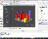 100% VCL native Charting component library with optional source code included. It provided entire featureset to create charts, maps and gauges in 2D, 3D and OpenGL. It supports Delphi, C++Builder, RAD Studio and FireMonkey.
Specifications:
-For Delphi 7, 2006, 2007, 2009, 2010, XE, XE2,...
100% VCL native Charting component library with optional source code included. It provided entire featureset to create charts, maps and gauges in 2D, 3D and OpenGL. It supports Delphi, C++Builder, RAD Studio and FireMonkey.
Specifications:
-For Delphi 7, 2006, 2007, 2009, 2010, XE, XE2,...
Platforms: Windows, Mac, Windows 8, Windows 7, iOS, Android, iPhone
| License: Shareware | Cost: $479.00 USD | Size: 317.77 MB | Download (59): TeeChart Pro VCL / FMX Download |
Released: October 27, 2012
|
Added: October 27, 2012 | Visits: 555
MySatellite can download and combine every Google Maps tile (road map, terrain or satellite) between two chosen Earth coordinates into one big image. Then, for example, that map can be printed out for your own use.
Platforms: Mac
| License: Shareware | Cost: $10.00 USD | Size: 102.4 KB | Download (58): MySatellite Download |
Released: June 13, 2012
|
Added: June 13, 2012 | Visits: 727
 View maps of Earth and other planets with PrettyMap! See current day and night regions, learn geography by taking the quiz, enjoy 3D elevation surfaces, measure distances between locations and create your own maps with special places! PrettyMap lets you view vector and raster maps and images...
Platforms: Windows, Pocket PC
| License: Shareware | Cost: $19.95 USD | Size: 4.02 MB | Download (56): PrettyMap - World Atlas and Maps, GPS Download |
Added: October 05, 2013 | Visits: 750
This app makes it easy to display a map for given address in django templates. No API keys, manual geocoding, html/js copy-pasting or django model changes is needed. Installation pip install geopy pip install django-easy-maps Then add 'easy_maps' to INSTALLED_APPS and run ./manage.py syncdb...
Platforms: *nix
| License: Freeware | Size: 10.24 KB | Download (56): django-easy-maps Download |
Released: August 13, 2012
|
Added: August 13, 2012 | Visits: 689
Anquet Maps for Mac is mapping, route-planning navigation software used by professional mountain guides, top mountain athletes, outdoor training centres and thousands of everyday walkers, climbers and cyclists.
With Anquet Maps for Mac you can create routes on real OS maps to print or transfer...
Platforms: Mac
| License: Freeware | Size: 4.8 MB | Download (54): Anquet Maps Download |
Released: September 24, 2012
|
Added: September 24, 2012 | Visits: 921
This software development kit (SDK) provides the binaries and programming reference for the Bing Maps WPF Control (Beta).
When the installation completes, you can choose to open the Bing Maps WPF Control (Beta) SDK help file (BingMapsWPFControlSDK.chm).
Get Bing Maps WPF Control and give it a...
Platforms: Windows, XP, 2003, Windows Vista, 2008, 7
| License: Freeware | Download (52): Bing Maps WPF Control Download |
Added: May 29, 2013 | Visits: 774
There are several plugins that can embed Google Maps into WordPress pages. However, most, if not all, of them require the user to specify the markup in a separate KML file. I found that troublesome, and hence created a plugin that allows the administrator to create a marker simply by clicking on...
Platforms: PHP
| License: Freeware | Size: 10 KB | Download (50): Organisation Maps Download |