


Nmea software
Nmea
Released: July 20, 2012
|
Added: July 20, 2012 | Visits: 469
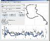
 GPS Express provides a feature rich interface to serial NMEA-0183 protocol data and works with most NMEA-0183 devices, including GPS Receivers. GPS Express is available in three versions (Standard, Professional, Graphical). STANDARD displays the title, value, and units for each parameter....
Platforms: Windows
GPS Express provides a feature rich interface to serial NMEA-0183 protocol data and works with most NMEA-0183 devices, including GPS Receivers. GPS Express is available in three versions (Standard, Professional, Graphical). STANDARD displays the title, value, and units for each parameter....
Platforms: Windows
| License: Shareware | Cost: $30.00 USD | Size: 2.1 MB | Download (47): GPS Express 3.x Download |
Released: November 22, 2012
|
Added: November 22, 2012 | Visits: 540
 mdNavMobile is a waypoint-based GPS navigation solution for the Windows Mobile platform. It can guide you from waypoint to waypoint while keeping you informed of all relevant navigation data. All NMEA-data from a GPS is automatically logged to file so you can 'replay' a trip with variable speed....
Platforms: Windows, Pocket PC, Handheld/Mobile Other
mdNavMobile is a waypoint-based GPS navigation solution for the Windows Mobile platform. It can guide you from waypoint to waypoint while keeping you informed of all relevant navigation data. All NMEA-data from a GPS is automatically logged to file so you can 'replay' a trip with variable speed....
Platforms: Windows, Pocket PC, Handheld/Mobile Other
| License: Freeware | Size: 30 KB | Download (48): mdNavMobile Download |
Released: June 11, 2012
|
Added: June 11, 2012 | Visits: 386
 This program takes NMEA, CSV, GPR or GPX logfiles from your GPS device, manages your tracks and exports them as KML to Google Earth. Investigate altitude and speed information, measure distances and cut tracks.
Platforms: Windows, Mac, Linux
This program takes NMEA, CSV, GPR or GPX logfiles from your GPS device, manages your tracks and exports them as KML to Google Earth. Investigate altitude and speed information, measure distances and cut tracks.
Platforms: Windows, Mac, Linux
| License: Freeware | Size: 1.77 MB | Download (46): GpRoko - Track Analyzer Download |
Released: October 12, 2012
|
Added: October 12, 2012 | Visits: 633
 A software gps simulator, providing TCP/IP, UDP, http and serial port connectivity in NMEA 0183, XML or user defined output format. Usable for testing all kinds of GPS applications. Can playback pre-recorded GPS files with NMEA output.
Platforms: Windows, Mac, Linux
A software gps simulator, providing TCP/IP, UDP, http and serial port connectivity in NMEA 0183, XML or user defined output format. Usable for testing all kinds of GPS applications. Can playback pre-recorded GPS files with NMEA output.
Platforms: Windows, Mac, Linux
| License: Freeware | Size: 30.56 KB | Download (78): gpsfeed+ Download |
Released: June 05, 2012
|
Added: June 05, 2012 | Visits: 273
Yet another tool to read and convert GPS logs from Royaltek RGM-3800 and RBT-2300 (using serial communication), from RBT-3000 (using files), from NMEA logs files (comming from AMOD 3080 datalogger for example).
Platforms: Windows, Mac, Linux
| License: Freeware | Size: 2.2 MB | Download (50): Jdatalog Download |
Released: December 25, 2012
|
Added: December 25, 2012 | Visits: 450
 GPS (NMEA 0183) extensible communication library written in Java. Handles standard GLL, GGA, RMC, GSA and GSV sentences and may be extended on application-level for handling any other sentence types. Bundle also contains GUI- and console-based GPS tool.
Platforms: Windows, Mac, Linux
GPS (NMEA 0183) extensible communication library written in Java. Handles standard GLL, GGA, RMC, GSA and GSV sentences and may be extended on application-level for handling any other sentence types. Bundle also contains GUI- and console-based GPS tool.
Platforms: Windows, Mac, Linux
| License: Freeware | Size: 94.75 KB | Download (48): JGPS Download |
Released: December 15, 2012
|
Added: December 15, 2012 | Visits: 529
![]() MATCH is an application for J2ME / JavaME enabled devices which allows tracking (recording of tracks) and route-navigation with your mobile phone and a NMEA-compliant Bluetooth GPS-Receiver when jogging or biking.
Platforms: Windows, Mac, Linux
MATCH is an application for J2ME / JavaME enabled devices which allows tracking (recording of tracks) and route-navigation with your mobile phone and a NMEA-compliant Bluetooth GPS-Receiver when jogging or biking.
Platforms: Windows, Mac, Linux
| License: Freeware | Size: 75.09 KB | Download (45): MATCH - Mobile Action Tracking Companion Download |
Released: November 27, 2012
|
Added: November 27, 2012 | Visits: 224
OpenNMEA is an open-source Java library for parsing NMEA sentence strings from GPS units into a more useful format, to facilitate interaction between your application and a GPS unit.
Platforms: Windows, Mac, Linux
| License: Freeware | Size: 180.16 KB | Download (44): OpenNMEA Download |
Released: July 19, 2012
|
Added: July 19, 2012 | Visits: 173
ParseMeFree is the NMEA 1083 lightweight parser library written in Java.The library is used to parse NMEA ASCII frames to Java readable objects.
Platforms: Windows, Mac, Linux
| License: Freeware | Size: 8.44 KB | Download (48): ParseMeFree Download |
Released: June 05, 2017
|
Added: August 02, 2017 | Visits: 326
 CP Splitter is a software tool that can split a TCP or UDP data stream into two or three identical data streams, so more than one application can simultaneously process the incoming data. For example, you can send NMEA 0183 data to a navigation application and simultaneously log the data using...
Platforms: Windows, Windows 7, Windows Server
CP Splitter is a software tool that can split a TCP or UDP data stream into two or three identical data streams, so more than one application can simultaneously process the incoming data. For example, you can send NMEA 0183 data to a navigation application and simultaneously log the data using...
Platforms: Windows, Windows 7, Windows Server
| License: Shareware | Cost: $50.00 USD | Size: 3.09 MB | Download (39): TCP Splitter Download |
Released: July 01, 2008
|
Added: July 03, 2008 | Visits: 3.598
 Pictomio is a software application for managing, categorizing, searching, and archiving photos, videos and other media files, and allows you to generate animated 2D and 3D slideshows. The extensive capabilities of the latest programmable 3D graphic cards are utilized for image decoding and...
Platforms: Windows, Windows Vista
Pictomio is a software application for managing, categorizing, searching, and archiving photos, videos and other media files, and allows you to generate animated 2D and 3D slideshows. The extensive capabilities of the latest programmable 3D graphic cards are utilized for image decoding and...
Platforms: Windows, Windows Vista
| License: Freeware | Size: 6.1 MB | Download (755): pictomio Download |
Added: August 31, 2008 | Visits: 3.348
GeoVisu is a visualization software for geographic data - graphic files, images and GPS. It provides real time GPS navigation (moving map - NMEA 0183 protocol or Garmin USB), displayed with diverse geographic data (MIF, GPX, NMEA, KML/KMZ, SHP, ECW, GeoTiff, MrSID). It can download waypoints,...
Platforms: Windows
| License: Freeware | Size: 1.5 MB | Download (1383): GeoVisu Download |
Added: August 18, 2008 | Visits: 1.097
GpsDiffuser is a software that diffuses real-time GPS data and can play files containing GPS data. Diffusion is done by sending sentences at format NMEA 0183 using UDP protocol. Diffused data comes either from a GPS receiver or source issuing on UDP in real time navigation mode, or from a...
Platforms: Windows
| License: Freeware | Size: 819 KB | Download (531): GpsDiffuser Download |
Released: May 25, 2018
|
Added: June 25, 2018 | Visits: 3.614
 HoudahGeo is a photo geocoding and geotagging tool for Mac. Use HoudahGeo to attach GPS coordinates and location names to your photos.
HoudahGeo writes EXIF and XMP geotags to JPEG and RAW image files. This creates a permanent record of where a photo was taken. Just like a GPS-enabled camera....
Platforms: Mac
HoudahGeo is a photo geocoding and geotagging tool for Mac. Use HoudahGeo to attach GPS coordinates and location names to your photos.
HoudahGeo writes EXIF and XMP geotags to JPEG and RAW image files. This creates a permanent record of where a photo was taken. Just like a GPS-enabled camera....
Platforms: Mac
| License: Demo | Cost: $39.00 USD | Size: 22.87 MB | Download (837): HoudahGeo Download |
Added: January 27, 2010 | Visits: 2.272
AIS Parser SDK (Automatic Identification System) is a ship tracking network using VHF transponders. AIS equipped ships are transmitting their positions, destinations, names, cargo types, etc. You can receive these transmissions using expensive AIS transponders, or receivers such as those...
Platforms: *nix
| License: Shareware | Cost: $199.00 USD | Download (234): AIS Parser SDK Download |
Added: July 22, 2010 | Visits: 841
KFreeFlight is a flightgear gui-frontend. KFreeFlight can launch it with the most common options without taping a very long command line. Some clicks and you can fly away. Why KFreeFlight ? Because all program I find doesnt have the common options I use. (NMEA for example) or cant be set up...
Platforms: *nix
| License: Freeware | Size: 1.4 MB | Download (101): KFreeFlight Download |
Added: January 25, 2010 | Visits: 651
Web Photos is a program for the rapid creation of photo albums for viewing on the web or CDs. The albums can be viewed with a standard web browser.The album consists of a front page that contains all the pictures of the album displayed as thumbnails. When one of the thumbnails is clicked you are...
Platforms: Mac
| License: Shareware | Cost: $0.00 USD | Download (88): Web Photos Download |
Added: January 25, 2010 | Visits: 1.056
Power On X is a tool for the calculation of statistical power. The program can perform calculations of required sample size to achieve a desired power, and calculations of power for previously run studies/experiments. In addition, the paid version can generate power/sample size tables.
Platforms: Mac
| License: Shareware | Cost: $0.00 USD | Download (119): Power on X Download |
Added: January 25, 2010 | Visits: 610
iCalMaker is an easy to use program for the rapid creation of vCal diary appointment files for use with iCal and other such applications. It can be used:to use an 'intelligent' import of appointment data from the clipboard to import appointments from tab and comma delimited files to import data...
Platforms: Mac
| License: Shareware | Cost: $0.00 USD | Download (98): iCalMaker Download |
Added: January 25, 2010 | Visits: 882
Terrabrowser is an internet browser for satellite photos and topographical maps which are obtained from the Microsoft Terra Server. The map data is provided by the U.S. Geological Survey (USGS) and therefore only covers the United States at this time (although expansion to other map servers may...
Platforms: Mac
| License: Shareware | Cost: $0.00 USD | Download (98): Terrabrowser Download |