


Latitude Longitude software
Latitude Longitude
Added: August 23, 2008 | Visits: 1.322
 United States ZIP codes database one month subscription service. The database includes ZIP code, city name, alias city name, state code, phone area code, city type, county name, country FIPS, time zone, day light saving flag, latitude, longitude, county elevation, MSA, PMSA and Census 2000 data...
Platforms: DOS, OS/2, Windows, Mac, *nix, Palm OS, Windows CE
United States ZIP codes database one month subscription service. The database includes ZIP code, city name, alias city name, state code, phone area code, city type, county name, country FIPS, time zone, day light saving flag, latitude, longitude, county elevation, MSA, PMSA and Census 2000 data...
Platforms: DOS, OS/2, Windows, Mac, *nix, Palm OS, Windows CE
| License: Shareware | Cost: $59.95 USD | Size: 27 KB | Download (95): United States ZIP Code Database (Gold Edition) May Download |
Added: August 21, 2008 | Visits: 1.101
United States ZIP codes database one month subscription service. The database includes ZIP code, city name, alias city name, state code, phone area code, city type, county name, country FIPS, time zone, day light saving flag, latitude, longitude and county elevation. The complete database...
Platforms: DOS, OS/2, Windows, Mac, *nix, Palm OS, Windows CE
| License: Shareware | Cost: $39.95 USD | Size: 27 KB | Download (94): United States ZIP Code Database (Premium Edition) May Download |
Released: April 21, 2008
|
Added: February 04, 2009 | Visits: 1.486
 FusionMaps v3 helps you create animated, interactive and data-driven Flash Maps for your dynamic web applications. Using FusionMaps, you can display geographical data distributed by category, regions or entities. Ideal usage examples are statistical display of data, flight routes, office...
Platforms: Windows, Mac, *nix
FusionMaps v3 helps you create animated, interactive and data-driven Flash Maps for your dynamic web applications. Using FusionMaps, you can display geographical data distributed by category, regions or entities. Ideal usage examples are statistical display of data, flight routes, office...
Platforms: Windows, Mac, *nix
| License: Shareware | Cost: $199.00 USD | Size: 26.77 MB | Download (144): FusionMaps Download |
Added: January 09, 2010 | Visits: 1.142
Geo::Lookup::ByTime is a Perl module to lookup location by time. SYNOPSIS use Geo::Lookup::ByTime; $lookup = Geo::Lookup::ByTime->new( @points ); my $pt = $lookup->nearest( $tm ); Given a set of timestamped locations guess the location at a particular time. This is a useful operation...
Platforms: *nix
| License: Freeware | Size: 15.36 KB | Download (94): Geo::Lookup::ByTime Download |
Added: August 24, 2010 | Visits: 1.494
GIS::Distance::Vincenty Perl module contains Thaddeus Vincenty distance calculations. SYNOPSIS my $calc = GIS::Distance::Vincenty->new(); my $distance = $calc->distance( $lon1, $lat1 => $lon2, $lat2 ); For the benefit of the terminally obsessive (as well as the genuinely needy), Thaddeus...
Platforms: *nix
| License: Freeware | Size: 8.19 KB | Download (125): GIS::Distance::Vincenty Download |
Added: September 07, 2010 | Visits: 1.220
libipgeo library is written on top of the IP2LOCATION database allowing the user to do geo-targeting of IP addresses. For a given IPv4 address, libipgeo can lookup the following: Country Code Country Region City Latitude Longitude ISP NEW:libipgeo now searchs the IP2LOCATION database in...
Platforms: *nix
| License: Freeware | Size: 133.12 KB | Download (132): ipgeo Download |
Added: July 07, 2010 | Visits: 853
Fracplanet is an interactive tool for creating random fractal planets and terrain areas with oceans, rivers, lakes and icecaps. The results can be saved in POV-Ray format. The code is licensed under the GPL. Fracplanet project uses Qt and OpenGL. Whats New in This Release: - The main...
Platforms: *nix
| License: Freeware | Size: 68.61 KB | Download (135): Fracplanet Download |
Added: August 05, 2010 | Visits: 668
OpenGuides is a wiki-like package for maintaining a collaborative city guide. It is written in Perl and runs as a CGI program, and uses either the MySQL, PostgreSQL, or SQLite database. OpenGuides offers features over a "normal" wiki such as metadata management and a "find nearby things"...
Platforms: *nix
| License: Freeware | Size: 94.21 KB | Download (93): OpenGuides Download |
Added: January 25, 2010 | Visits: 1.310
GPS Connect is a freeware program for Mac OS X which offers connectivity to Garmin GPS receivers. The intended use is to backup waypoints from the GPS to your computer. Downloaded waypoints may be saved in a native file format or exported to a variety of other formats such as tab-delimited,...
Platforms: Mac
| License: Freeware | Size: 1.2 MB | Download (108): GPS Connect Download |
Added: January 25, 2010 | Visits: 698
CoordinatesX is an application that transforms geodetic and Cartesian coordinates. It will make the conversions from Geodetic latitude, longitude and heights to planet centered Cartesian coordinates and vice versa. Works for various planetary ellipsoids, including user defined...
Platforms: Mac
| License: Freeware | Download (165): CoordinatesX Download |
Added: January 25, 2010 | Visits: 812
3D Weather & Globe allows you to view weather patterns all over the world, with real-time cloud cover and a 7-day forecast.An astronaut's-eye-view of the EarthMountains, rivers, lakes, and desertsReal-time weather and cloud cover7-day forecast including wind and humidityDay/night line changing...
Platforms: Mac
| License: Shareware | Cost: $0.00 USD | Download (119): 3D Weather & Globe Atlas Download |
Released: October 22, 2012
|
Added: October 22, 2012 | Visits: 469
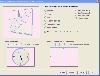 Shadows is a program used to design sundials and astrolabes. It can be used by everybody without any required technical skills. Shadows will calculate everything and print the drawing according the user's preferences. Shadows is used by thousands of users around the world.
Shadows offers a...
Platforms: Windows
Shadows is a program used to design sundials and astrolabes. It can be used by everybody without any required technical skills. Shadows will calculate everything and print the drawing according the user's preferences. Shadows is used by thousands of users around the world.
Shadows offers a...
Platforms: Windows
| License: Freeware | Size: 7.5 MB | Download (457): Shadows Download |
Released: July 20, 2012
|
Added: July 20, 2012 | Visits: 521
With GeopIPTC you will be able to read the IPTC city information in pictures and get the corresponding coordinates to your photos from several free services and embed this into the pictures in standard tags in a very professional way. You will also create sets of pictures with all the metadata...
Platforms: Windows
| License: Shareware | Cost: $104.55 USD | Size: 7.32 MB | Download (382): GeoIPTC Download |
Released: October 06, 2012
|
Added: October 06, 2012 | Visits: 513
With GeoIPTC you will be able to read the IPTC city information in pictures and get the corresponding coordinates to your photos from several free services and embed this into the pictures in standard tags in a very professional way. You will also create sets of pictures with all the metadata...
Platforms: Windows
| License: Shareware | Cost: $112.00 USD | Size: 7.32 MB | Download (455): GeoIPTC Geolocalisation de Photos Download |
Released: November 09, 2012
|
Added: November 09, 2012 | Visits: 491
 Arrange photos in folders and sub-folders or use filters (keywords, ratings, favorites) to find your photos. Geocoding data displays where an image was taken on Google maps. Plus, this .app allows you to view a photos metadata and arrange the order of your photos (manual, rating, date, file size)...
Platforms: iOS
Arrange photos in folders and sub-folders or use filters (keywords, ratings, favorites) to find your photos. Geocoding data displays where an image was taken on Google maps. Plus, this .app allows you to view a photos metadata and arrange the order of your photos (manual, rating, date, file size)...
Platforms: iOS
| License: Shareware | Cost: $2.99 USD | Size: 7.1 MB | Download (483): Photo Folder Download |
Released: November 14, 2012
|
Added: November 14, 2012 | Visits: 5.022
 Professional Free Kundli software in Hindi from Astro-Vision. Ideal for Astrologers and Astrology Students. Contains both calculations as well as predictions. This free kundali software also provides you a choice of chart formats, like, North Indian, South Indian, etc. This means you can generate...
Platforms: Windows
Professional Free Kundli software in Hindi from Astro-Vision. Ideal for Astrologers and Astrology Students. Contains both calculations as well as predictions. This free kundali software also provides you a choice of chart formats, like, North Indian, South Indian, etc. This means you can generate...
Platforms: Windows
| License: Freeware | Size: 24.21 MB | Download (1436): Free Kundli Software Download |
Released: November 27, 2012
|
Added: November 27, 2012 | Visits: 741
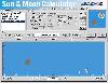 This shows the position of the sun and moon for any place on earth between 1900 and 2049. It can show the sun or moon for any day or the horizon which can be rotated 360 degrees and animated. A database of over 1600 locations is included which includes the name, latitude, longitude and time zone...
Platforms: Windows, Other
This shows the position of the sun and moon for any place on earth between 1900 and 2049. It can show the sun or moon for any day or the horizon which can be rotated 360 degrees and animated. A database of over 1600 locations is included which includes the name, latitude, longitude and time zone...
Platforms: Windows, Other
| License: Shareware | Cost: $39.00 USD | Size: 3.21 MB | Download (527): Sun & Moon Calculator Download |
Released: July 20, 2012
|
Added: July 20, 2012 | Visits: 1.236
The database includes a list of more than 9,000 Post Office Box (PO Box) only ZIP codes, state and city name.
It is bundled with the ZIPCodeWorld US Gold Edition which includes 5-Digit ZIP code, city name, alias city name, state code, phone area code, city type, country name, country FIPS, time...
Platforms: Windows
| License: Freeware | Download (484): US ZIP Code Database PO Box Edition Download |
Released: August 19, 2012
|
Added: August 19, 2012 | Visits: 456
No matter if you are an experienced player, a highly-handicapped beginner, or even a golf coach, GXP3 + iGXP is a great application suite to improve your golf game. This is because GXP3 and iGXP was created by players to players. No fancy useless graphics. Just the info you need, where you want...
Platforms: Mac
| License: Freeware | Size: 20 MB | Download (482): GXP for Mac OS Download |
Released: October 09, 2012
|
Added: October 09, 2012 | Visits: 276
Know where you took that photo! With HoudahGeo you may 'pin' photos to locations where they were taken. Just like an expensive GPS camera, HoudahGeo may store latitude, longitude, altitude and viewing direction information right within the image file - invisibly with no loss of quality. HoudahGeo...
Platforms: Mac
| License: Freeware | Size: 6.4 MB | Download (446): HoudahGeo for Mac OS Download |