


Kml Files Editor software
Kml Files Editor
Released: July 23, 2012
|
Added: July 23, 2012 | Visits: 486
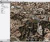
 T2K Pro integrates the rich world of GIS datasets and transfers your Geographic information data into Google earth. T2K Pro handles rich data types and access large volumes of geographic data stored in files and databases; T2K PRO handles raster (imagery), Vector Map data and GPS Tracks/...
Platforms: Windows
T2K Pro integrates the rich world of GIS datasets and transfers your Geographic information data into Google earth. T2K Pro handles rich data types and access large volumes of geographic data stored in files and databases; T2K PRO handles raster (imagery), Vector Map data and GPS Tracks/...
Platforms: Windows
| License: Shareware | Cost: $90.00 USD | Size: 20.89 MB | Download (54): T2K Pro Download |
Released: September 14, 2012
|
Added: September 14, 2012 | Visits: 316
T2K PLUS or Tiles2Kml PLUS enables you to efficiently load large set of imagery or raster maps very quickly into Google Earth using Region-Based Network Links. This method has an onRegion option, which specifically loads the Region data only when the Region is active. Thus only the needed set of...
Platforms: Windows
| License: Shareware | Cost: $40.00 USD | Size: 8.39 MB | Download (47): T2K PLUS Download |
Released: September 17, 2012
|
Added: September 17, 2012 | Visits: 430
 Are you madly in love with music? Then you should know that every love needs to be tended and cultivated. It is no different with music.
LightMan TagEditor is exactly the program to do that with - tend to your passion. Devoted to making tag processing easy for those who are first of all music...
Platforms: Windows
Are you madly in love with music? Then you should know that every love needs to be tended and cultivated. It is no different with music.
LightMan TagEditor is exactly the program to do that with - tend to your passion. Devoted to making tag processing easy for those who are first of all music...
Platforms: Windows
| License: Freeware | Size: 5.12 MB | Download (702): LightMan TagEditor Download |
Released: November 01, 2012
|
Added: November 01, 2012 | Visits: 489
 The Capturix GPS SDK is a ActiveX OCX Control that provide Visual Basic Developers the interface between GPS receivers and their applications. This is a very simple control with a simple configuration methods and very easy to implement. It provides direct support to MapQuest website and creates...
Platforms: Windows
The Capturix GPS SDK is a ActiveX OCX Control that provide Visual Basic Developers the interface between GPS receivers and their applications. This is a very simple control with a simple configuration methods and very easy to implement. It provides direct support to MapQuest website and creates...
Platforms: Windows
| License: Shareware | Cost: $39.00 USD | Size: 1.02 MB | Download (55): Capturix GPS SDK Download |
Released: June 20, 2012
|
Added: June 20, 2012 | Visits: 701
 Make graph into Googlr Earth to illustrate your presentations, papers, etc. GE-Graph was developed to generate graphs from kml files saved by GE. The file generated by GE-Graph can be exported to Google Earth. Make Bars graph Make graph with geometrical shapes (circles, squares, triangles, etc)....
Platforms: Windows
Make graph into Googlr Earth to illustrate your presentations, papers, etc. GE-Graph was developed to generate graphs from kml files saved by GE. The file generated by GE-Graph can be exported to Google Earth. Make Bars graph Make graph with geometrical shapes (circles, squares, triangles, etc)....
Platforms: Windows
| License: Freeware | Size: 1.81 MB | Download (57): GE-Graph Download |
Released: October 03, 2013
|
Added: October 27, 2013 | Visits: 820
 Owing a vast collection of Mp3s is immensely rewarding for any music listener but it can also turn out to be quite a challenge when wanting to find a certain file, create playlists or, simply, organize your music on categories.
MC Audio Tagger is the perfect tool to take that challenge. It's...
Platforms: Windows, Windows 7
Owing a vast collection of Mp3s is immensely rewarding for any music listener but it can also turn out to be quite a challenge when wanting to find a certain file, create playlists or, simply, organize your music on categories.
MC Audio Tagger is the perfect tool to take that challenge. It's...
Platforms: Windows, Windows 7
| License: Freeware | Size: 2.53 MB | Download (67): MC Audio Tagger Download |
Released: December 01, 2012
|
Added: December 01, 2012 | Visits: 455
 Javascript authoring tool that can edit multiple files. Editor has color syntax highlighting and always shows line numbers. Many pieces of Javascript and HTML template text may be inserted from menus. All Javascript code is extracted and syntax checked and checked for integration to the...
Platforms: Windows
Javascript authoring tool that can edit multiple files. Editor has color syntax highlighting and always shows line numbers. Many pieces of Javascript and HTML template text may be inserted from menus. All Javascript code is extracted and syntax checked and checked for integration to the...
Platforms: Windows
| License: Shareware | Cost: $29.00 USD | Size: 1.31 MB | Download (54): ScrypTik Download |
Added: July 14, 2013 | Visits: 233
GESCATTER creates a .kml file that displays colored circles at the locations specified by the vectors LON and LAT similar to ML's builtin function, SCATTER.The color of the circles is scaled relative to the values provided in third input, C.I searched the FEX's many submissions dealing with...
Platforms: Matlab
| License: Freeware | Size: 10 KB | Download (48): GESCATTER Download |
Added: July 29, 2013 | Visits: 400
Timeline Map was built as a Views 2 style plug-in.It is based on Timemap.js project, so Timemap.js (from http://code.google.com/p/timemap/) has to be included in the moduled-deOaos js directory.It allows you to load one or more datasets onto both a map and a timeline simultaneously. Only items in...
Platforms: PHP
| License: Freeware | Size: 30.72 KB | Download (45): Timelinemap Download |
Added: July 16, 2013 | Visits: 367
CocoaSlideShow is a Mac OS X simple, fast image viewer, spiritual son of Slides!. CocoaSlideShow is the perfect companion for iPhone GPS tagged photos. With CocoaSlideShow you can: * easily select a few pictures out of big folders screencast * display your photos fullscreen, and use Apple...
Platforms: Mac
| License: Freeware | Size: 10.24 KB | Download (40): CocoaSlideShow Download |
Added: June 21, 2013 | Visits: 267
simplekml is a python package which enables you to generate KML with as little effort as possible. At the time of making this package nothing was available (at least I could not find anything) that could create KML files easily. You needed a lot of bloated code to even create a simple point....
Platforms: *nix
| License: Freeware | Size: 20.48 KB | Download (45): simplekml Download |
Released: June 09, 2005
|
Added: June 21, 2006 | Visits: 1.828
 DF_Language scans your projects for any properties of controls and belong all source code. A simple text file (.lan) is created and can be edited for adding new languages. In matter of minutes your software is ready for multi languages support. You may distribute the language files editor for...
Platforms: Windows
DF_Language scans your projects for any properties of controls and belong all source code. A simple text file (.lan) is created and can be edited for adding new languages. In matter of minutes your software is ready for multi languages support. You may distribute the language files editor for...
Platforms: Windows
| License: Shareware | Cost: $10.00 USD | Size: 2.04 MB | Download (110): DF_Language Download |
Released: August 10, 2012
|
Added: August 10, 2012 | Visits: 481
 WindRose PRO plots wind roses, minimum, average and maximum values and rays.
WindRose PRO is a software for plotting wind roses and other directional data.
Data can be loaded as comma separated values (CSV) files or from Excel files.
Plots can be saved in BMP format or exported in DXF...
Platforms: Windows
WindRose PRO plots wind roses, minimum, average and maximum values and rays.
WindRose PRO is a software for plotting wind roses and other directional data.
Data can be loaded as comma separated values (CSV) files or from Excel files.
Plots can be saved in BMP format or exported in DXF...
Platforms: Windows
| License: Shareware | Cost: $81.20 USD | Size: 5.4 MB | Download (446): WindRose PRO Download |
Released: June 13, 2012
|
Added: June 13, 2012 | Visits: 452
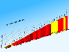 CycloGraph is a handy program to help you plot the gradient of roads using distances and heights. An Open Source alternative to Salitaker for plotting the profile of the roads you are planning to do with your bicycle. It also can import routes from kml. FEATURES: · import kml files · open...
Platforms: Windows
CycloGraph is a handy program to help you plot the gradient of roads using distances and heights. An Open Source alternative to Salitaker for plotting the profile of the roads you are planning to do with your bicycle. It also can import routes from kml. FEATURES: · import kml files · open...
Platforms: Windows
| License: Freeware | Size: 16.2 MB | Download (504): CycloGraph Download |
Released: July 09, 2012
|
Added: July 09, 2012 | Visits: 541
 Automatically extract from a geotagged image’s metadata, and then visually imprint (stamp), the GPS position, location description, altitude, date, date and time, or any combination of these or any other file metadata, onto a photo with no loss in image quality. It is a lossless JPEG process...
Platforms: Windows
Automatically extract from a geotagged image’s metadata, and then visually imprint (stamp), the GPS position, location description, altitude, date, date and time, or any combination of these or any other file metadata, onto a photo with no loss in image quality. It is a lossless JPEG process...
Platforms: Windows
| License: Freeware | Size: 11.9 MB | Download (406): GPStamper Download |
Released: September 22, 2012
|
Added: September 22, 2012 | Visits: 499
Did you ever want to know how far that running route is? Are you planning for a biking tour? Or do you train for a marathon and wonder where you should go for your long distance runs? Or would you like to know how far you must run to burn that 1000 calories? Then TrailRunner mini is the route...
Platforms: Mac
| License: Commercial | Cost: $19.99 USD | Size: 1.9 MB | Download (50): TrailRunner mini Download |
Released: November 18, 2012
|
Added: November 18, 2012 | Visits: 364
Did you ever want to add high-resolution maps of your trips to your photo album? No problem with myPhotoMap.
You can select from a broad variety of map types: OpenStreetMap Mapnik, Osmarender, MapQuest, OpenCycleMap and Cloudmade. Additionally satellite maps from NASA BlueMarble and NearMap...
Platforms: Mac
| License: Commercial | Cost: $4.99 USD | Size: 2.8 MB | Download (57): myPhotoMap Download |
Added: May 12, 2013 | Visits: 204
Import a .kml file as a series of shapefile structs. Like kml_shapefile, but more stable.Import a Google Earth .kml file of points, lines, polygons, or a combination, as a Matlab struct, compatible with the Mapping Toolbox features, and with shapefiles imported with shaperead().Structs are...
Platforms: Matlab
| License: Shareware | Cost: $0.00 USD | Size: 10 KB | Download (44): kml2struct Download |
Added: July 11, 2013 | Visits: 440
This plugin lets you save location information with posts, pages, and other WordPress objects. These objects can then be presented on interactive Google maps in many ways.ExamplesThere's a community sourced list of examples in action. People do all kinds of amazing things with Geo...
Platforms: PHP
| License: Freeware | Size: 419.84 KB | Download (51): Geo Mashup Download |
Added: July 07, 2013 | Visits: 322
This module will geocode just about anything you throw at it or hook up to it including addresses, GPX files, geo-tagged images, and KML files.It is commonly used to automatically geocode Addressfield addresses into Geofield points for display on Openlayers Maps.This module also makes available...
Platforms: PHP
| License: Shareware | Cost: $0.00 USD | Size: 10 KB | Download (39): Geocoder (Sripts) Download |