


Global Positioning Satellite Images software
Global Positioning Satellite Images
Released: August 20, 2012
|
Added: August 20, 2012 | Visits: 684
 View amazing satellite images of earth with the free version of google earth software.Google earth is a totally free software which enables you zoom in from satellite,view,rotate or tilt just like a camera of the entire earth inside your pc.It works just point and click on any part of earth or by...
Platforms: Windows
View amazing satellite images of earth with the free version of google earth software.Google earth is a totally free software which enables you zoom in from satellite,view,rotate or tilt just like a camera of the entire earth inside your pc.It works just point and click on any part of earth or by...
Platforms: Windows
| License: Freeware | Size: 798 KB | Download (529): Free Satellite images Download |
Released: August 11, 2014
|
Added: October 09, 2014 | Visits: 1.064
 Maps Downloader For Google Satellite is a smart tool which can help you download tile satellite images from google map fastly and stably.It can stitch tile images into one big seamless image:Software can stitch tile images into one big seamless image such as GeoTIFF and GeoJPEG. But if the...
Platforms: Windows, Windows 7, Windows Server
Maps Downloader For Google Satellite is a smart tool which can help you download tile satellite images from google map fastly and stably.It can stitch tile images into one big seamless image:Software can stitch tile images into one big seamless image such as GeoTIFF and GeoJPEG. But if the...
Platforms: Windows, Windows 7, Windows Server
| License: Shareware | Cost: $49.95 USD | Size: 4.74 MB | Download (1240): Maps Downloader For Google Satellite |
Released: July 01, 2012
|
Added: July 01, 2012 | Visits: 512
Can you imagine how large an satellite image is, which has dimensions of 86400 pixels wide and 43200 pixels high?This is a simple article which describes the Worlds Largest Satellite Images.See the largest satellite images using a free software which is included inside.This free software will...
Platforms: Windows
| License: Freeware | Size: 590 KB | Download (523): Largest Satellite Images Download |
Released: January 02, 2004
|
Added: August 02, 2006 | Visits: 3.005
 Global Positioning Submitter is a country specific foreign search engine submission software package. Developed to target search engines in a specific country, thereby facilitating the promotion of web sites in a geographical area based on target market preferences.
Platforms: Windows
Global Positioning Submitter is a country specific foreign search engine submission software package. Developed to target search engines in a specific country, thereby facilitating the promotion of web sites in a geographical area based on target market preferences.
Platforms: Windows
| License: Demo | Cost: $49.00 USD | Size: 1.76 MB | Download (162): Global Positioning Submitter Download |
Added: August 13, 2013 | Visits: 398
In large scale mapping projects with numerous satellite images, it is useful to have a vector file depicting the boundary of the images. This script when run from the folder containing the images, it automatically detects the geotiffs and extracts their image area boundary and constructs a...
Platforms: Matlab
| License: Freeware | Size: 10 KB | Download (49): GeoTiff PathRow Download |
Added: January 25, 2010 | Visits: 860
GPSy is a sophisticated Macintosh GPS communications and GIS mapping program. GPSy connects your Macintosh to a broad range of Global Positioning System (GPS) navigational units and has advanced mapping, logging, and data transfer features. GPSy has extensive support for USGS DRG topo maps,...
Platforms: Mac
| License: Demo | Cost: $0.00 USD | Download (104): GPSy Download |
Added: April 11, 2013 | Visits: 744
In the past several years compact radio navigation receivers have proliferated in the civilian market place, generally under the name of GPS or Global Positioning System. Appearing as handheld units or built into cars, mobile phones, and airplanes, these commercial applications originated from a...
Platforms: Matlab
| License: Freeware | Size: 1.04 MB | Download (45): GPS Navigation Toolbox GNT Download |
Released: November 06, 2004
|
Added: July 05, 2006 | Visits: 3.086
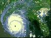 Eye in the Sky screensaver contains 43 detailed satellite images of Earth. The following images are included: Antarctica, Argentina, Asian dust cloud over Korea and Japan, Australia, Bahamas, Bosporus Straits - Turkey, Central America, Coral Atolls, Cuba Florida and Bahamas, Cypress, Dasht-e...
Platforms: Windows
Eye in the Sky screensaver contains 43 detailed satellite images of Earth. The following images are included: Antarctica, Argentina, Asian dust cloud over Korea and Japan, Australia, Bahamas, Bosporus Straits - Turkey, Central America, Coral Atolls, Cuba Florida and Bahamas, Cypress, Dasht-e...
Platforms: Windows
| License: Demo | Cost: $11.00 USD | Size: 4.54 MB | Download (117): Eye in the Sky Download |
Added: August 18, 2008 | Visits: 1.355
 Allows you to connect your hand held Global Positioning System (GPS) unit to your computer, download your waypoints, and plot them in AutoCAD or export them in .dxf Also plots the points on free public domain Aerial photos and topo maps. Works on most Garmin and Magellan GPS units, and AutoCAD...
Platforms: Windows
Allows you to connect your hand held Global Positioning System (GPS) unit to your computer, download your waypoints, and plot them in AutoCAD or export them in .dxf Also plots the points on free public domain Aerial photos and topo maps. Works on most Garmin and Magellan GPS units, and AutoCAD...
Platforms: Windows
| License: Shareware | Cost: $345.00 USD | Size: 9.9 MB | Download (543): GPS2CAD Download |
Added: August 14, 2008 | Visits: 1.841
GPS (Global Positioning System) receivers tell you where you are anywhere on the planet! The Global Positioning System (GPS) is a collection of 24 earth-orbiting satellites and these satellites allow any person who owns a GPS receiver to determine his or her precise longitude, latitude and...
Platforms: ALL
| License: Freeware | Download (223): How a GPS Receiver Works Download |
Added: January 25, 2010 | Visits: 783
X-Sat is a utility that downloads directly from the Internet the latest satellite images among a predefined set of areas (Earth, USA, Europe, Africa, Asia...). You can configure X-Sat to download automatically a given satellite image each time you launch it.
Platforms: Mac
| License: Shareware | Cost: $0.00 USD | Size: 72 KB | Download (171): X-Sat X Download |
Added: January 25, 2010 | Visits: 819
Geocaching Menu makes it easy to download geocaching waypoints from webpages directly to your GPS device without the need of first saving these on the computer. Geocaching is an outdoor activity that most often involves the use of a Global Positioning System ("GPS") receiver or traditional...
Platforms: Mac
| License: Shareware | Cost: $0.00 USD | Download (108): Geocaching Menu Download |
Released: September 24, 2012
|
Added: September 24, 2012 | Visits: 533
Simultaneously displays animated radar and satellite images for multiple locations in the United States. The user can configure data source types and visual preferences.
Platforms: Mac
| License: Freeware | Size: 2.6 MB | Download (47): RadSat for Mac OS Download |
Released: July 18, 2012
|
Added: July 18, 2012 | Visits: 503
 QWeather shows the current Satellite images (sky and cloud conditions) (440x300 pixel). The easiest and quickest way to view the current world wide images from The Weather Channel updated every 3 hours. In addition the program can animate the last 12 maps already downloaded. Available maps: North...
Platforms: Windows
QWeather shows the current Satellite images (sky and cloud conditions) (440x300 pixel). The easiest and quickest way to view the current world wide images from The Weather Channel updated every 3 hours. In addition the program can animate the last 12 maps already downloaded. Available maps: North...
Platforms: Windows
| License: Demo | Cost: $19.44 USD | Size: 911 KB | Download (46): QWeather - Quick Weather Download |
Released: July 13, 2012
|
Added: July 13, 2012 | Visits: 497
 The gpstoolbox project provides a portable Garmin GPS (Global Positioning System) interface library and associated utilities to support creating, transfering, and processing of route, track log, waypoint, and PVT data. Supported platforms include Linux,
Platforms: Windows, Mac, Linux
The gpstoolbox project provides a portable Garmin GPS (Global Positioning System) interface library and associated utilities to support creating, transfering, and processing of route, track log, waypoint, and PVT data. Supported platforms include Linux,
Platforms: Windows, Mac, Linux
| License: Freeware | Size: 245.55 KB | Download (48): gpstoolbox Download |
Added: January 25, 2010 | Visits: 704
Mac SimpleGPS is Macintosh application designed to manage waypoints, routes and tracks on your GPSR (global positioning satellite receiver). The best use for Mac SimpleGPS is to download .LOC (waypoint location) files from GeoCaching.com and transfer them to your GPSr. It is also a great way to...
Platforms: Mac
| License: Freeware | Download (101): Mac SimpleGPS Download |
Released: October 31, 2023
|
Added: December 23, 2023 | Visits: 94
 google earth images downloader is a tool that help you to get offline satellite tile images from google earth (not google maps), including historical imagery. It can work without google earth installed. After downloading, there are some ways to view the offline maps: You can view downloaded...
Platforms: Windows 8, Windows 7, Windows
google earth images downloader is a tool that help you to get offline satellite tile images from google earth (not google maps), including historical imagery. It can work without google earth installed. After downloading, there are some ways to view the offline maps: You can view downloaded...
Platforms: Windows 8, Windows 7, Windows
| License: Shareware | Cost: $55.00 USD | Size: 29.56 MB | Download (16): google earth images downloader |
Released: September 01, 2008
|
Added: September 06, 2008 | Visits: 2.353
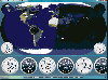 ActiveEarth is a world time clock with a gorgeous day/night merge of NASA's Visible Earth satellite images in flat maps or a globe, with a row of user-definable clocks along the bottom. These clocks are beautiful, scalable, ticking, analog or digital clocks that come in several styles with many...
Platforms: Windows
ActiveEarth is a world time clock with a gorgeous day/night merge of NASA's Visible Earth satellite images in flat maps or a globe, with a row of user-definable clocks along the bottom. These clocks are beautiful, scalable, ticking, analog or digital clocks that come in several styles with many...
Platforms: Windows
| License: Demo | Cost: $24.95 USD | Size: 3.54 MB | Download (187): ActiveEarth Download |
Added: January 25, 2010 | Visits: 1.404
GPSUtility displays GPS data including speed, bearing, position and satellite information.
Platforms: Mac
| License: Freeware | Download (148): GPSUtility Download |
Added: June 01, 2013 | Visits: 538
Your Planet Today displays a satellite map of the Earth in the sidebar of your blog. With the Google Maps integration, you can zoom in and pan around. All the satellite images used to generate the map are between 3 and 36 hours old. With this widget you can monitor global weather patterns, dust...
Platforms: PHP
| License: Freeware | Size: 10 KB | Download (41): Your Planet Today widget Download |