


Gis Geographic Information System software
Gis Geographic Information System
Released: June 21, 2012
|
Added: June 21, 2012 | Visits: 911
 Commonly referred to as GRASS, this is a free Geographic Information System (GIS) used for geospatial data management and analysis, image processing, graphics/maps production, spatial modeling, and visualization. GRASS is currently used in academic and commercial settings around the world, as...
Platforms: Mac
| License: Freeware | Size: 59 MB | Download (57): Grass GIS for Mac OS X Download |
Added: November 28, 2013 | Visits: 466
 FMaps is here to answer the lack of user friendly opensource GIS/RS (Geographic Information System/ Remote Sensing) application on the Linux and Gnome compatible platforms.
Platforms: *nix
| License: Freeware | Size: 225.28 KB | Download (38): FMaps Download |
Added: August 04, 2008 | Visits: 1.169
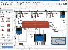
 GIS ObjectLand is a universal Geographic Information System for Windows. Key capabilities: vector-raster maps; multiuser data editing; import and export for MIF/MID (MapInfo), SHP (ArcView), DXF (AutoCAD), DBF (dBASE), CSV; setting access permissions to data for different categories of users;...
Platforms: Windows
| License: Shareware | Cost: $99.00 USD | Size: 23.54 MB | Download (537): GIS ObjectLand Download |
Added: June 04, 2013 | Visits: 602
The Homeless Management Information System (HMIS) allows organizations providing services to the homeless to collect client information electronically. The HMIS uses a web-based interface generated by PHP, and backed by MySQL.
Platforms: PHP
| License: Shareware | Cost: $0.00 USD | Size: 1.21 MB | Download (43): Homeless Mangement Information System Download |
Released: August 16, 2012
|
Added: August 16, 2012 | Visits: 529
uDig is a user-friendly desktop Internet GIS, a core element in an internet aware Geographic Information System.
The application is an open source spatial data viewer / editor, that comes with a special emphasis on the OpenGIS standards for internet GIS, the Web Map Server and Web Feature Server...
Platforms: Windows
| License: Freeware | Download (439): uDig Download |
Released: October 01, 2012
|
Added: October 01, 2012 | Visits: 948
 Visual Graph is a standard ActiveX component for developing graphics-related applications of various industries, such as power, coal, chemical, automation monitor, simulation, graphical modeling, graphical topology analysis, vector drawing, tables, geographic information system (GIS), workflow,...
Platforms: Windows
| License: Freeware | Size: 6.66 MB | Download (68): Visual Graph ActiveX Component Download |
Released: July 20, 2012
|
Added: July 20, 2012 | Visits: 796
 A health information system built on Mono/.NET that will include components like a web application for storing patient data, a practice management system, a number of modules for specific healthcare industries, among other things.
Platforms: Windows, Mac, Linux
| License: Freeware | Size: 1 MB | Download (59): Endeavor Health Information System Download |
Added: May 10, 2013 | Visits: 632
The Homeless Management Information System (HMIS) allows organizations providing services to the homeless to collect client information electronically. The HMIS uses a web-based interface generated by PHP. The HMIS is designed to be flexible, secure and protect client confidentiality. The HMIS...
Platforms: Windows, Mac, *nix, PHP, BSD Solaris
| License: Freeware | Download (61): Homeless Management Information System Download |
Added: May 21, 2010 | Visits: 915
CartoWeb is a comprehensive and ready-to-use Web-GIS (Geographical Information System) as well as a convenient framework for building advanced and customized applications. Developed by Camptocamp SA, it is based on the UMN MapServer engine and is released under the GNU General Public License...
Platforms: *nix
| License: Freeware | Size: 11.6 MB | Download (109): CartoWeb Download |
Released: June 08, 2012
|
Added: June 08, 2012 | Visits: 446
Mapyrus is software to plot Geographic Information System data to PostScript, PDF, SVG and web image files. Mapyrus combines a BASIC-like scripting language, reading GIS datasets and running as either a utility program, a Java Servlet, or as a webser
Platforms: Windows, Mac, Linux
| License: Freeware | Size: 3.27 MB | Download (48): mapyrus Download |
Released: July 25, 2007
|
Added: September 26, 2007 | Visits: 3.503
 AvisMap GIS Engine is a comprehensive SDK for the development of custom GIS applications and solutions. This SDK provides several ActiveX (OCX) controls which support Visual Basic, VB.NET, C#, Visual C++ and other ActiveX compatible programming languages, with Microsoft Visual Studio versions 6,...
Platforms: Windows
| License: Shareware | Cost: $199.00 USD | Size: 43.76 MB | Download (157): AvisMap GIS Engine Download |
Released: June 22, 2012
|
Added: June 22, 2012 | Visits: 705
Thuban is an interactive geographic data viewer (GIS viewer) which features methods to visualize, explore, and analyze geographic information.
Thuban is an Interactive Geographic Data Viewer with the following features:
# Vector Data Support: Shapefile, PostGIS Layer and OGR
# Raster Data...
Platforms: Windows
| License: Freeware | Size: 11.22 MB | Download (429): Thuban for Windows Download |
Released: October 21, 2012
|
Added: October 21, 2012 | Visits: 743
Thuban is an interactive geographic data viewer (GIS viewer) which features methods to visualize, explore, and analyze geographic information.
Thuban is an Interactive Geographic Data Viewer with the following features:
# Vector Data Support: Shapefile, PostGIS Layer and OGR
# Raster Data...
Platforms: Linux
| License: Freeware | Size: 1.18 MB | Download (464): Thuban for Linux Download |
Released: December 30, 2019
|
Added: January 08, 2020 | Visits: 3.185
 TOPOWIN is a state-wide register of the German Topographic Cartographies, the German Basic Cartography and of localities with geo references in different coordinate systems. It is also a topographic information system. In the division of planning and execution of economical and scientific...
Platforms: Windows, Windows 8, Windows 7, Windows Server
| License: Shareware | Cost: $125.00 USD | Size: 4.56 MB | Download (271): TOPOWIN Download |
Added: March 27, 2006 | Visits: 3.307
EzGIS Components target applications are GIS (Geographic Information System). Although it is new on GIS market, its highlights implemented quality and a lot of features will expand your develops applications.
There are a lot of applications that you can develop with our EzGIS components, like :...
Platforms: Windows
| License: Shareware | Cost: $799.00 USD | Size: 3.61 MB | Download (219): EzGIS Download |
Released: March 04, 2003
|
Added: January 18, 2006 | Visits: 2.713
 ExGIS (OCX Control) target applications are GIS (Geographic Information System). Although it is a new kid on the block on GIS market, its highlights implemented quality and a lot of features.
There are a lot of applications that you can develop with our ExGIS components, like :
Marketing...
ExGIS (OCX Control) target applications are GIS (Geographic Information System). Although it is a new kid on the block on GIS market, its highlights implemented quality and a lot of features.
There are a lot of applications that you can develop with our ExGIS components, like :
Marketing...
Platforms: Windows, Windows CE
| License: Shareware | Cost: $599.00 USD | Size: 36.13 MB | Download (158): ExGIS Download |
Released: April 24, 2008
|
Added: November 24, 2009 | Visits: 6.364
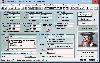
 HospitalGate is a Network and Multi-User Hospital Information System - HIS, Electronic Medical record Software and FREE Hospital Admission software for Samll-medium Hospital that contain all the Financial, Clinical, and Operational elements For a successful running Medical Office. HospitalGate...
Platforms: Windows
| License: Shareware | Cost: $898.00 USD | Size: 94.28 MB | Download (1830): HospitalGate Download |
Added: March 07, 2010 | Visits: 1.205
Cicerone is a multi-platform/server/database, Web-based corporate information system that allows to maintain infos on the fly. It supports any type of file attachment, built in security levels, user and system-wide customizations, automatic import of syndicated news and content, custom email...
Platforms: *nix
| License: Freeware | Size: 122.88 KB | Download (100): Cicerone 1.4 Download |
Added: January 25, 2010 | Visits: 1.541
Centre School Information System is an open-source, web-based student information system. Centre has been designed to address the most important needs of administrators, teachers, support staff, parents, students, and clerical personnel. However, it also adds many components not typically found...
Platforms: Mac
| License: Freeware | Size: 1.6 MB | Download (197): Centre School Information System Download |
Added: January 25, 2010 | Visits: 650
OwlView is a simple thematic mapping application that can combine data exported from a spreadsheet or database with geographic boundaries to produce maps that visually display patterns of spatial distribution within the data. It includes four classification methods (Equal Counts, Equal Ranges,...
Platforms: Mac
| License: Shareware | Cost: $0.00 USD | Download (86): OwlView Download |