


Geographic Information Systems software
Geographic Information Systems
Added: January 25, 2010 | Visits: 1.233
 ArcExplorer is a lightweight GIS data viewer developed by ESRI. This freely available software offers an easy way to perform basic GIS functions. ArcExplorer is used for a variety of display, query, and data retrieval applications and supports a wide variety of standard data sources. It can be...
Platforms: Mac
ArcExplorer is a lightweight GIS data viewer developed by ESRI. This freely available software offers an easy way to perform basic GIS functions. ArcExplorer is used for a variety of display, query, and data retrieval applications and supports a wide variety of standard data sources. It can be...
Platforms: Mac
| License: Freeware | Size: 13.3 MB | Download (161): ArcExplorer Download |
Added: January 25, 2010 | Visits: 933
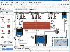
GrassPro is based on the free, open-source product "GRASS 6.0.1 GIS." It offers offers a host of ready-to-use GIS software and utilities, including: MapServer for publishing dynamic, navigable maps with layers over the Internet; PostGIS which enables spatial, geographic support for the included...
Platforms: Mac
| License: Demo | Cost: $0.00 USD | Download (109): GrassPro Download |
Released: January 14, 2011
|
Added: September 27, 2011 | Visits: 1.046
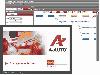 How can job scheduling software A-AUTO help your business? -A real story
A travel insurance company in Japan had been using a task manager to run batch jobs. When one job precedes another, an operator set the time for the succeeding job to begin by estimating the end time of the preceding...
Platforms: Windows
How can job scheduling software A-AUTO help your business? -A real story
A travel insurance company in Japan had been using a task manager to run batch jobs. When one job precedes another, an operator set the time for the succeeding job to begin by estimating the end time of the preceding...
Platforms: Windows
| License: Shareware | Cost: $6875.00 USD | Size: 88.92 MB | Download (112): A-AUTO Download |
Released: August 16, 2012
|
Added: August 16, 2012 | Visits: 531
uDig is a user-friendly desktop Internet GIS, a core element in an internet aware Geographic Information System.
The application is an open source spatial data viewer / editor, that comes with a special emphasis on the OpenGIS standards for internet GIS, the Web Map Server and Web Feature Server...
Platforms: Windows
| License: Freeware | Download (439): uDig Download |
Released: October 01, 2012
|
Added: October 01, 2012 | Visits: 952
 Visual Graph is a standard ActiveX component for developing graphics-related applications of various industries, such as power, coal, chemical, automation monitor, simulation, graphical modeling, graphical topology analysis, vector drawing, tables, geographic information system (GIS), workflow,...
Platforms: Windows
Visual Graph is a standard ActiveX component for developing graphics-related applications of various industries, such as power, coal, chemical, automation monitor, simulation, graphical modeling, graphical topology analysis, vector drawing, tables, geographic information system (GIS), workflow,...
Platforms: Windows
| License: Freeware | Size: 6.66 MB | Download (68): Visual Graph ActiveX Component Download |
Released: August 12, 2012
|
Added: August 12, 2012 | Visits: 633
DTM DB Stress is a utility for stress testing the server parts of information systems and applications, as well as DBMSs and servers themselves. DTM DB Stress is an intuitive application that can be used by anyone, regardless of their computer skills.
This tool allows you to create and configure...
Platforms: Windows
| License: Freeware | Download (51): DTM DB Stress Professional Download |
Released: June 16, 2012
|
Added: June 16, 2012 | Visits: 479
CatMDEdit is a metadata editor tool for describing resources, mainly geographic information. Developed by IAAA (University of Zaragoza) and GeoSpatiumLab S.L., sponsored by IGN Spain. Technical details: Java, XML, multiplatform, multilingual.
Platforms: Windows, Mac, Linux
| License: Freeware | Size: 80.58 MB | Download (49): CatMDEdit - metadata editor Download |
Released: June 25, 2012
|
Added: June 25, 2012 | Visits: 309
The Research Geographic Information Kernel developed by Charles Ehlschlaeger and team.
Platforms: Windows, Mac, Linux
| License: Freeware | Size: 2.28 MB | Download (51): Ehlschlaeger RGIK Download |
Released: June 08, 2012
|
Added: June 08, 2012 | Visits: 450
Mapyrus is software to plot Geographic Information System data to PostScript, PDF, SVG and web image files. Mapyrus combines a BASIC-like scripting language, reading GIS datasets and running as either a utility program, a Java Servlet, or as a webser
Platforms: Windows, Mac, Linux
| License: Freeware | Size: 3.27 MB | Download (48): mapyrus Download |
Released: July 16, 2012
|
Added: July 16, 2012 | Visits: 373
Data Quality Assurance application for use by Immunization Information Systems (IIS). Implements guidance in MIROW Chapter 3 Data Quality Assurance in Immunization Information Systems.
Platforms: Windows, Mac, Linux
| License: Freeware | Size: 3.04 MB | Download (54): OIS DQA Download |
Released: December 08, 2012
|
Added: December 08, 2012 | Visits: 334
PanBI is a collection of analytics modules for existing information systems. For each IS, it provides data extraction, transformation and loading logic coupled with an OLAP schema, delivering OLAP functionality to an unprecedented user base.
Platforms: Windows, Mac, Linux
| License: Freeware | Size: 75.21 MB | Download (56): PanBI Download |
Released: December 16, 2012
|
Added: December 16, 2012 | Visits: 460
Res Medicinae is the attempt to overcome high pricing in the realm of medical information systems and to provide users with a stable, platform independent, extensive system using latest technology and being open to many other medical systems.
Platforms: Windows, Mac, Linux
| License: Freeware | Size: 22.75 MB | Download (44): Res Medicinae Download |
Released: July 10, 2012
|
Added: July 10, 2012 | Visits: 348
Web-based Information Systems for Everybody. Declare screens and DB tables of your application in XML, and have JSPs, session & CMP entity EJBs generated automatically. All that is needed to develop are business logic model classes as POJO.
Platforms: Windows, Mac, Linux
| License: Freeware | Size: 1.54 MB | Download (53): Simple Enterprise Application Framework Download |
Released: July 15, 2012
|
Added: July 15, 2012 | Visits: 574
 USE is a system for the specification and validation of information systems based on a subset of the Unified Modeling Language (UML) and the Object Constraint Language (OCL). Please report any encountered bugs using Mantis (reachable via 'Hosted Apps')
Platforms: Windows, Mac, Linux
USE is a system for the specification and validation of information systems based on a subset of the Unified Modeling Language (UML) and the Object Constraint Language (OCL). Please report any encountered bugs using Mantis (reachable via 'Hosted Apps')
Platforms: Windows, Mac, Linux
| License: Freeware | Size: 20.75 MB | Download (45): USE: UML-based Specification Environment Download |
Released: October 08, 2012
|
Added: October 08, 2012 | Visits: 509
wiwwu LaTeX styles is a collection of LaTeX classes and style files for generating term papers, theses and presentations using the design that is proposed by the institute for information systems at the WWU MALnster, Germany.
Platforms: Windows, Mac, Linux
| License: Freeware | Size: 376.94 KB | Download (49): wiwwu LaTeX styles Download |
Released: December 01, 2012
|
Added: December 01, 2012 | Visits: 376
Wobzilla is component framework for building document or form-orientend GUI-Frontends for information-systems. Its implemented in JavaScript and uses a XSLT-like definition-language. It runs on Mozilla (Version 1.3 or higher).
Platforms: Windows, Mac, Linux
| License: Freeware | Size: 2.28 MB | Download (48): Wobzilla Download |
Added: May 10, 2013 | Visits: 323
PostGIS adds support for geographic objects to the PostgreSQL object-relational database. In effect, PostGIS "spatially enables" the PostgreSQL server, allowing it to be used as a backend spatial database for geographic information systems (GIS).
Platforms: Windows, Mac, *nix, C/C++, BSD Solaris
| License: Freeware | Download (55): PostGIS Script Download |
Added: June 04, 2013 | Visits: 274
* Retrieve user's geographic information based on her ip address. This module is based on a relative accurate IP database from http://www.maxmind.com/app/geolitecity, which is free and will be updated regularly. Every time a user logs in, her ip address and geographic information will be updated...
Platforms: PHP
| License: Freeware | Size: 20.48 KB | Download (44): GeoUser Download |
Added: September 13, 2013 | Visits: 469
Our undergraduate degrees include BSc in Computing Science, Information Systems, Software Engineering, Business Computing, Mathematics and its Applications together with a large selection of combined and joint degrees. Postgraduate qualifications include the MSc in Advanced Computing, the MSc...
Platforms: Mac
| License: Freeware | Size: 629 B | Download (39): DiceTotal Download |
Released: April 22, 2008
|
Added: April 26, 2008 | Visits: 9.520
 The free AvisMap Viewer opens most GIS/CAD and raster image file types and most ArcView, ArcExplorer, and MapInfo projects. Besides just opening and viewing files, the Viewer supports an extensive list of features including visual layer properties control, legend control, thematic mapping,...
Platforms: Windows
The free AvisMap Viewer opens most GIS/CAD and raster image file types and most ArcView, ArcExplorer, and MapInfo projects. Besides just opening and viewing files, the Viewer supports an extensive list of features including visual layer properties control, legend control, thematic mapping,...
Platforms: Windows
| License: Freeware | Size: 22.28 MB | Download (1734): AvisMap Free Viewer Download |