


Geo Mapping software
Geo Mapping
Added: June 21, 2013 | Visits: 647
 This plugin creates custom post type with geo locations for back end data entering, Google Maps Api v3 is used to display geo posts onto a map with clickable markers overlay, geo posts html content then can be displayed in a popup window. Without any change this tool can be used to build a store...
Platforms: PHP
| License: Freeware | Size: 20.48 KB | Download (50): CleanCodeNZ Geo Posts Plugin Download |
Added: September 15, 2013 | Visits: 224
Some web mapping clients like leaflet or polymaps only accept json as an input format. This product produces it. It does not have any user interface, it just provides a GeoJson view for contentitems, folders and collections. To test just append @@geo-json.json at the url.
Platforms: *nix
| License: Shareware | Cost: $0.00 USD | Size: 10.24 KB | Download (32): collective.geo.json Download |
Released: February 03, 2004
|
Added: March 24, 2006 | Visits: 3.802
 The CANVAS 9 GIS Mapping Edition adds native support for Geographic Information System (GIS) data to Canvas. You can take measurements in geographic coordinates, import industry standard SHAPE and GeoTIFF files into unlimited numbers of automatically aligned overlapping layers and choose among...
Platforms: Windows
| License: Shareware | Cost: $549.99 USD | Size: 53.3 MB | Download (188): Canvas GIS Mapping Edition Download |
Released: May 23, 2014
|
Added: July 02, 2014 | Visits: 3.118
 The database tables contains geodata of the Federal Republic of Germany with geo referenced towns, municipalities, town quarters and other administrative units, postal codes, telephone preselections, nature areas, landscapes, climatic zones and official topographical cartographies. The data...
Platforms: Windows, Mac, *nix, DOS, Windows 8, Windows Phone, Windows 7, Windows Server, Palm OS, Android, Handheld, OS/2, BlackBerry,Java
| License: Demo | Cost: $205.00 USD | Size: 1.79 MB | Download (128): Geodaten Deutschland Download |
Added: August 11, 2008 | Visits: 1.217
 Easy Chart 3D GEO is easy to use graphical reporting tool for effortless generation of complex business, management, financial and ad-hoc geographical charts (Pie, Cylinder or Cube) of professional quality.Charts are generated on top of a geographical maps (3D-look). Geographical Maps available:...
Platforms: Windows
| License: Shareware | Cost: $295.00 USD | Size: 8.5 MB | Download (520): Easy Chart 3D GEO Download |
Added: August 18, 2010 | Visits: 887
Shazou (pronounced Shazoo it is Japanese for mapping) enables the user with one-click to map and geo-locate any website they are currently viewing. Shazou was developed as a tool to improve the awareness for people surfing the internet about where and who they are interacting with every click...
Platforms: *nix
| License: Freeware | Size: 7.17 KB | Download (97): Shazou Download |
Added: July 12, 2010 | Visits: 1.468
Dr. Geo is a GTK interactive geometry software. It allows one to create geometric figure plus the interactive manipulation of such figure in respect with their geometric constraints. It is useable in teaching situation with students from primary or secondary level. Dr. Geo integrates advanced...
Platforms: *nix
| License: Freeware | Size: 768 KB | Download (200): Dr. Geo Download |
Added: January 25, 2010 | Visits: 1.089
Geo-Calc works out all the measurements (area, perimeter, sides, angles, etc.) of common geometric shapes. A scaled drawing of each calculated shape is shown with a graph paper background in one drawer, while another shows a history of your previous calculations. A definition of each shape and...
Platforms: Mac
| License: Shareware | Cost: $0.00 USD | Download (147): Geo-Calc Download |
Released: October 18, 2012
|
Added: October 18, 2012 | Visits: 639
 The database tables contains geodata of the Federal Republic of Germany with geo referenced towns, municipalities, town quarters and other administrative units, postal codes, telephone preselections and nature areas, landscapes and climatic zones. The data contain coordinates for navigation and...
Platforms: All
| License: Shareware | Cost: $195.00 USD | Size: 1.63 MB | Download (59): Geodaten German Admin Download |
Released: August 15, 2012
|
Added: August 15, 2012 | Visits: 880
Geodata of the European and International countries offers you municipalities and postal codes. Georeferences as UTM- and geographic coordinates (WGS84, ETRS89). Suitable for branch searches, periphery searches and distance computations.
International Geo Data with geo referenced localities and...
Platforms: Windows
| License: Freeware | Download (54): Geo Data International Admin (English) Download |
Released: July 15, 2012
|
Added: July 15, 2012 | Visits: 846
Geodata of the European and International countries offers you municipalities and postal codes. Georeferences as UTM- and geographic coordinates (WGS84, ETRS89). Suitable for branch searches, periphery searches and distance computations.
International Geo Data with geo referenced localities and...
Platforms: Windows
| License: Freeware | Download (50): Geo Data International Admin Download |
Released: December 31, 2019
|
Added: January 08, 2020 | Visits: 1.303
 The database tables contains geodata of the Federal Republic of Germany with geo referenced towns, municipalities, town quarters and other administrative units, postal codes, telephone preselections, nature areas, landscapes, climatic zones and official topographical cartographies. The data...
Platforms: Windows, Mac, *nix, Windows 8, Windows 7, Windows Server, iOS, Android, iPhone,iPad
| License: Data Only | Cost: $175.00 USD | Size: 3.61 MB | Download (162): Geodata Germany Download |
Released: August 25, 2012
|
Added: August 25, 2012 | Visits: 629
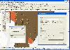
 GPS Mapping Software for Windows, Loading topographic maps, realtime navigation, track recording, manage GPS devices and more. The software can be used with various map formats including: GeoTiff, BSB Nautical Charts, AutoCad DXF files, ESRI Shapefiles. Using calibration you can also use scanned...
Platforms: Windows
| License: Shareware | Cost: $149.00 USD | Size: 11.13 MB | Download (48): Eye4Software GPS Mapping Studio Download |
Released: August 17, 2012
|
Added: August 17, 2012 | Visits: 430
Where are your Internet visitors coming from?
IP Address Country mapping Database can help you identify visitor's geographical location of an IP address. The IP Address to Country Code Database can be used for:
1>Real Time Geo-Locating ( Country )
2>Redirect based on country...
Platforms: Windows, Mac, Linux,Palm,OS
| License: Shareware | Cost: $49.95 USD | Size: 235 KB | Download (385): IP-Country mapping Database Download |
Released: October 16, 2012
|
Added: October 16, 2012 | Visits: 1.012
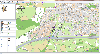
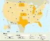 USA Real Estate Map Pro is a premium class software for mapping: real estate properties, contact listings, offices and other geo spatial data. Interactive Real Estate map is rather simple to integrate with database listings: both to specify the states and counties that should be active on map,...
Platforms: Windows, Mac, OS/2, Unix, Linux, MS-DOS, AS/400
| License: Shareware | Cost: $399.00 USD | Size: 10.42 MB | Download (520): USA Real Estate Map Pro Download |
Released: December 08, 2012
|
Added: December 08, 2012 | Visits: 656
 Detail process maps for documenting, developing, improving and managing business processes. Graham process maps clearly show the interrelated flows and relationships of multiple forms, emails, reports, databases, systems and other items in a process. Used to support business process improvement...
Platforms: Windows
| License: Commercial | Cost: $99.00 USD | Size: 13.27 MB | Download (585): Graham Process Mapping Starter Edition Download |
Released: October 07, 2012
|
Added: October 07, 2012 | Visits: 444
A generator for Castor JDO Mapping's that uses the database information
Platforms: Windows, Mac, Linux
| License: Freeware | Size: 12.71 KB | Download (51): Crea Castor JDO Mapping Download |
Released: August 16, 2012
|
Added: August 16, 2012 | Visits: 332
 Gnumler is a 'mapping framework'. It is able to generate Hibernate xml mapping using a GUI, importing data from database or creating it via the embedded editor. It was born as a thesis project at Politecnico di Milano.
Platforms: Windows, Mac, Linux
| License: Freeware | Size: 1.98 MB | Download (48): Gnumler mapping framework Download |
Released: November 21, 2012
|
Added: November 21, 2012 | Visits: 518
Java Port Mapping between 2 hosts. Put up a server on your local network and share it with the outside network in a secure way. A 'server proxy' network tool. Share one IP with multiple servers.
Platforms: Windows, Mac, Linux
| License: Freeware | Size: 10.19 KB | Download (59): Java Port Mapping Download |
Released: November 10, 2012
|
Added: November 10, 2012 | Visits: 429
Object Mapping Project (OMaP) proposes a way to define and to perform mappings of Java object instances. The objects could be mapped to a XML String, another Java object, database records, Swing screens, etc. And, of course, mapping back is also supported
Platforms: Windows, Mac, Linux
| License: Freeware | Size: 449.3 KB | Download (49): Java Object Mapping Project Download |