


Versamap for Windows 2.07 |
Date Added: July 26, 2006 | Visits: 2.367 |
|
||||||||||
|
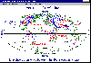
Versamap draws outline maps on 14 map projections. The program allows users to print publication quality maps on any printer supported by Windows; and to export maps in vector graphic (WMF, CGM, DXF, ASCII) and bitmapped (BMP) formats.
|

| License: Shareware | Cost: $30.00 USD | Size: 896 KB |
USER REVIEWS
VERSAMAP FOR WINDOWS RELATED
|
Home & Leisure
-
Altimeter Digital GPS + Map Viewer + Cam 1.0
" The most accurate and handly Altimeter is here. It gives you the altitude wherever you are. Simply start the app and altitude will appear in a second, No setup required. You can also adjust Altitude in Feet or Meter as per your requirement.... |
||
|
Teaching Tools
-
Map Worksheet Factory 2.0.1028
Quickly and easily create professional outline-map worksheets for lessons in geography, history, social studies, and current events. See exactly what your maps will look like as you design them with the WYSIWYG interface. Zoom and pan to select... |
6.28 MB | |
|
Multimedia & Graphics
-
SeamlessMaker for Mac OS 1.1
Apply amazing and beautiful effects very easily like Droste effect (recursive picture), kaleidoscope, mandala, conformal map (topography, projection), cartoon, painting, anaglyph, textures ... You can make endless zoom movies ! You can also... |
108 MB | |
|
Video Players
-
TABULA FacadeSignage Video Mapping 1.7
FacadeSignage is a novel Digital Signage solution: the easiest projection mapping software on the market. Use a PC and one (or more) projectors to dress any physical object or architectural structure with digital media. Easy to Setup: No need... |
153.63 MB | |
|
Multimedia & Graphics
-
Ortelius 1.0.8
A full-featured and affordable vector drawing application especially for cartography. Create custom map graphics and scaled plans for reports, publications, websites, and presentations. Special cartography tools allow you to draw directly with... |
43.2 MB | |
|
Home & Leisure
-
ediTrail 1.0
Importation/Exportation: Import/export trails to gpx file. Unlimited number of trails, and TrackPoints. Export to gpx, Excel, PDF, XPS and KML/KMZ. Data table: Very flexible data table that allows sorting by columns, with inheritance of data,... |
27.05 MB | |
|
Multimedia & Graphics
-
ConceptDraw MINDMAP Professional 5.2.2
ConceptDraw MINDMAP 5 is a mind-mapping and team brainstorming tool. It has many drawing tools and a rich collection of pre-drawn shapes. Use it to efficiently organize your ideas and tasks with the help of Mind Mapping technique. ConceptDraw... |
35.08 MB | |
|
Multimedia Integration Tools
-
ConceptDraw MINDMAP Professional Mac 5.2.2
ConceptDraw MINDMAP 5 is a mind-mapping and team brainstorming tool. It has many drawing tools and a rich collection of pre-drawn shapes. Use it to efficiently organize your ideas and tasks with the help of Mind Mapping technique. ConceptDraw... |
48.25 MB | |
|
Development Editors
-
FotoMaps 2.0
FotoMaps is compact flash gallery designed to help you display your pictures on an interactive map. The user can choose any map, then place each photo at the exact location where it was taken. This geographical context gives your photographs... |
||
|
Graphics Editors
-
T2K Pro 2.31
T2K Pro integrates the rich world of GIS datasets and transfers your Geographic information data into Google earth. T2K Pro handles rich data types and access large volumes of geographic data stored in files and databases; T2K PRO handles raster... |
20.89 MB |
NEW DOWNLOADS IN EDUCATION, SCIENCE
|
Education
-
Writers Desk 6.03
Writer's Desk is for creative writers, not businesses. Manage your writing projects to write anything faster, better, easier. Work with one file in a project or many. Keep records on people, places, events, notes, and references to have your... |
10.51 MB | |
|
Education
-
KeroSoft FunnyPaint 2.0
KeroSoft FunnyPaint is a simple and fun software program for kids to express themselves by drawing, painting and using the creative elements provided. Provides various drawing and painting tools - KeroSoft FunnyPaint provides comprehensive... |
47.82 MB | |
|
Education
-
FC Compiler 1.510
FC-Compiler (tm) is a Calculus-level Compiler, helps Tweak parameters.. The FortranCalculus (FC) language is for math modeling, simulation, and optimization. FC is based on Automatic Differentiation that simplifies computer code to an absolute... |
11.12 MB | |
|
Education
-
Antiplagiarism 1.2
Antiplagiarism - program will check if your diploma thesis is not a plagiarism. The Antiplagiarism software detects a possibility of commiting plagiarism with the highest efficiency among solutions available on the market. A professional system... |
21.29 MB | |
|
Education
-
PDFMate eBook Converter 1.0.1
PDFMate eBook Converter is a professional eBook Converter specially developed for converting eBook to other popular formats like EPUB, MOBI, PDF, AZW, TXT. Besides, PDFMate eBook Converter is a powerful eBook removal tool which can easily remove... |
80.42 MB | |
|
Science
-
Smart Grid Simulations 8.24
Smart Grid Simulations is a collection of Business Planners in (x/y/t) that allow you to calculate your personal Household Power Supply. With PV Energy, Battery, Wind Turbine, Water Supply, and Public Infastructure, all you need for a Smart Grid... |
7.35 MB | |
|
Science
-
Wind Turbine 8.07
Wind Turbine is an interactive Return on Investment Planner for Renewable Energies. It brings various small Simulations based on the Dynamic Applications Platform of Business Planners. The Simulation Model Wind Turbine - Power Generation is... |
6.44 MB | |
|
Science
-
Model Analyzer Tool 1.0
The Model Analyzer Tool is a compact and user-friendly Windows software specifically crafted for analyzing and evaluating modeling results. Tailored features make it a comprehensive solution for model analysis, providing informative insights.... |
10.9 MB | |
|
Science
-
Thiessen Polygon Tool 1.0
Thiessen Polygons, or Voronoi Polygons, are geometric constructs dividing a plane based on proximity to given points. Named after Alfred Thiessen, each polygon encapsulates points closer to its origin than any other. Formed by connecting midpoints... |
28.67 MB | |
|
Science
-
KNN WG 1.1
The K-nearest neighbors (K-NN) is an analogous approach. This method has its origin as a non-parametric statistical pattern recognition procedure to distinguish between different patterns according to a selection criterion. Through this method,... |
64.25 MB |