Mapwel Build-8.8-2011 |
|
|
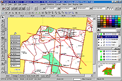
All-in-one software for creation of custom GPS maps compatible with Garmin GPS units. Mapwel supports routing, ESRI shapefiles, OpenStreetMap OSM, Google Earth KML and KMZ, cGPSmapper MP and GPX files. Mapwel custom GPS mapping capability and user icons editor are often used in forestry, electrical engineering, geology and geodesy. Creation of a GPS map involves georeference of raster images, drawing of the vector map, import of data from...
|