


Plot Gps Data freeware
Plot Gps Data
Added: June 23, 2013 | Visits: 344
 QtGrace is a version of Grace based on the Qt-SDK by Nokia. QtGrace/Grace is a program to display or plot data, analyze data and prepare it for printing. Using QtGrace is to run Grace natively on Windows, Mac OS X and Linux. Features . Import numerical data (like scientific measurements,...
Platforms: *nix
| License: Freeware | Size: 11.46 MB | Download (34): QtGrace For Linux Download |
Added: April 14, 2013 | Visits: 586
I wrote this to plot some overlapping data sets with there means and regions of +/- std deviations shown. It could be used for other purposes though.
Platforms: Matlab
| License: Freeware | Size: 10 KB | Download (47): Plot Overlapping Regions With Lines Download |
Added: January 09, 2010 | Visits: 2.547
Chart::Plot::Canvas is a Perl module to plot two dimensional data in an Tk Canvas. SYNOPSIS use Chart::Plot::Canvas; my $img = Chart::Plot::Canvas->new(); my $anotherImg = Chart::Plot::Canvas->new ($image_width, $image_height); $img->setData (@dataset) or die( $img->error() );...
Platforms: *nix
| License: Freeware | Size: 5.12 KB | Download (162): Chart::Plot::Canvas Download |
Added: July 10, 2010 | Visits: 1.473
GPS::PRN is a package for PRN - Object ID conversions. SYNOPSIS use GPS::PRN; my $obj = GPS::PRN->new(); print "PRN: ", $obj->prn_oid(22231), "n"; print "OID: ", $obj->oid_prn(1), "n"; This module maps GPS PRN number to Satellite OID and vice versa. Object Identification Number (OID)...
Platforms: *nix
| License: Freeware | Size: 4.1 KB | Download (230): GPS::PRN Download |
Released: October 23, 2012
|
Added: October 23, 2012 | Visits: 650
GPS Utility is an easy-to-use application that provides management and manipulation of GPS information. You can use it to transfer data to/from a GPS receiver and store the data in PC files in one of several text formats.
The program converts between different map datums and many coordinate...
Platforms: Windows
| License: Freeware | Size: 1.87 MB | Download (469): GPS Utility Download |
Released: June 03, 2012
|
Added: June 03, 2012 | Visits: 723
The Genome Positioning System (GPS) is a software tool to study protein-DNA interaction using ChIP-Seq data. GPS builds a probabilistic mixture model to predict the most likely positions of binding events at single-base resolution.
GPS is a Java software, so it runs on multiple platforms,...
Platforms: Windows
| License: Freeware | Download (430): GPS Download |
Released: September 27, 2012
|
Added: September 27, 2012 | Visits: 705
 Complex of programs FPS provide remote monitoring of GPS receivers and visualize data on a computer operator. The program presented for the free use can track the position of only one GPS-receiver. As GPS receivers can be used smartphone with GPS operating systems to Windows Mobile 5 or 6 and...
Platforms: Windows, Mac, Unix, Linux, Linux Gnome, Linux GPL, Linux Open Source
| License: Freeware | Size: 7.85 MB | Download (53): FPS система GPS мониторинга Download |
Released: September 08, 2009
|
Added: September 14, 2009 | Visits: 3.869
 PhotoGPSEditor is an easy to use meta-data editor for photo (JPEG, RAW) files, plus it can match data from GPS (gpx or NMEA) files. The program is freeware, however, donations can be made to help support future development. With PhotoGPSEditor you can add location and summary details to a...
Platforms: Mac
| License: Freeware | Size: 2.39 MB | Download (1330): PhotoGPSEditor Download |
Added: July 25, 2010 | Visits: 990
A free IDL (Interactive Data Language) compatible incremental compiler (ie. runs IDL programs). IDL is a registered trademark of Research Systems Inc. Full syntax compatibility with IDL 6.0 ALL IDL language elements are supported, including: - Objects, - Pointers, - Structs, - Arrays, -...
Platforms: *nix
| License: Freeware | Size: 839.68 KB | Download (96): The Data Language Download |
Added: March 24, 2010 | Visits: 1.180
GPS::SpaceTrack is a package for calculating the position of GPS satellites. SYNOPSIS use GPS::SpaceTrack; my $obj=GPS::SpaceTrack->new(filename=>"gps.tle"); print join("t", qw{Count PRN ELEV Azim SNR USED}), "n"; foreach ($obj->getsatellitelist({lat=>38.870997, lon=>-77.05596})) { print...
Platforms: *nix
| License: Freeware | Size: 52.22 KB | Download (117): GPS::SpaceTrack Download |
Added: June 21, 2010 | Visits: 1.463
QLandkarte can view and upload map files, track and waypoint data to your Garmin GPS receiver. Garmins MapSource software is hardly the only reason for me to boot into Windows and it does not look like Garmin ever wants to address Linux users by writing a portable piece of software. So I...
Platforms: *nix
| License: Freeware | Size: 972.8 KB | Download (116): QLandkarte Download |
Added: January 25, 2010 | Visits: 1.304
GPS Connect is a freeware program for Mac OS X which offers connectivity to Garmin GPS receivers. The intended use is to backup waypoints from the GPS to your computer. Downloaded waypoints may be saved in a native file format or exported to a variety of other formats such as tab-delimited,...
Platforms: Mac
| License: Freeware | Size: 1.2 MB | Download (108): GPS Connect Download |
Released: September 10, 2012
|
Added: September 10, 2012 | Visits: 683
QtGrace is a small, easy to use application specially designed to offer users a program to display or plot data, analyze data and prepare it for printing.
This software is special because it combines the convenience of a graphical user interface with the power of a scripting language which...
Platforms: Windows, Windows Vista, 7
| License: Freeware | Download (454): QtGrace Download |
Released: July 01, 2012
|
Added: July 01, 2012 | Visits: 750
 Atom GPS freeware easily geotags your photos directly from your GPS device or track log. By simply connecting your GPS Device to Atom GPS and selecting your photos you can add their geolocation in one click. This action allows you to write the geolocation data to your photos exifs (information...
Platforms: Windows
| License: Freeware | Size: 7.58 MB | Download (424): ATOM GPS Download |
Released: November 10, 2012
|
Added: November 10, 2012 | Visits: 704
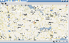
 Have a GPS and a laptop? Use this to find your way. Make patterns or a trail to share with others. When the application starts, you may pick your area of operations - be it North America, South America, Europe and Asia, or Australia. Your quadrant is determined by where you are in relation to the...
Platforms: Windows
| License: Freeware | Size: 4.56 MB | Download (503): LAS GPS Monitor LT Download |
Released: July 07, 2012
|
Added: July 07, 2012 | Visits: 914
 Universal oscilloscope GUI ( Real-time plot ) DLL library for data acquisition, simulation, debugging.Advantages:1.Speedy performance: the library makes it possible to bring out into the beams of the viewing oscilloscope over a million quantization steps of signal per second (on the Pentium III...
Platforms: Windows, Windows Vista
| License: Freeware | Size: 3.54 MB | Download (121): Universal Software Oscilloscope Library Download |
Released: September 14, 2012
|
Added: September 14, 2012 | Visits: 625
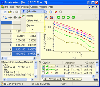 Data Master 2003 VCL component library provides you with high performance 2D graphics engine specially optimized for scientific and technical applications as well as other reusable components created for DM2003 software. You can visualize and edit numeric data as plot curves and worksheets,...
Platforms: Windows
| License: Freeware | Size: 307.2 KB | Download (58): Data Master 2003 VCL Download |
Released: November 07, 2012
|
Added: November 07, 2012 | Visits: 615
 With this tool you can add GPS coordinates to vCards - electronic business cards - that you have previously exported from e. g. Microsoft Outlook. Therefore the tool uses the address data contained within the vCards and adds the exact GPS position on that basis to the vCard. This way you can use...
Platforms: Windows
| License: Freeware | Size: 1.47 MB | Download (503): GPS to vCard Download |
Added: September 10, 2013 | Visits: 473
Plot Digitizer is a Java program used to digitize scanned plots of functional data. Often data is found presented in reports and references as functional X-Y type scatter or line plots. In order to use this data, it must somehow be digitized. This program will allow you to take a scanned image of...
Platforms: Mac
| License: Freeware | Size: 1.16 MB | Download (47): Plot Digitizer Download |
Added: May 10, 2013 | Visits: 360
It can be used to plot only discrete data, not having support for mathematical functions. Limitations: - Does not support functions. - Don't suit all applciations.
Platforms: Windows, Mac, *nix, Python, BSD Solaris
| License: Freeware | Download (54): Graphication Download |