


Multimedia Information System freeware
Multimedia Information System
Released: October 16, 2012
|
Added: October 16, 2012 | Visits: 453
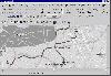
 The Tennessee Traffic Cameras widget provides a simple and easy way to view traffic cameras from across the state of Tennessee, all in one place. The traffic widget ties into the TDOT Smartway Information System, the city of Brentwood, the city of Franklin and the city of Murfreesboro.
Currently...
The Tennessee Traffic Cameras widget provides a simple and easy way to view traffic cameras from across the state of Tennessee, all in one place. The traffic widget ties into the TDOT Smartway Information System, the city of Brentwood, the city of Franklin and the city of Murfreesboro.
Currently...
Platforms: Mac
| License: Freeware | Size: 163.84 KB | Download (53): Tennessee Traffic Cameras Download |
Released: June 15, 2012
|
Added: June 15, 2012 | Visits: 368
Provide the building blocks for a GIS system consistent with the current standards from OGIS
Platforms: Windows, Mac, Linux
| License: Freeware | Size: 9.43 MB | Download (52): Geographical Information System Toolkit Download |
Released: October 07, 2012
|
Added: October 07, 2012 | Visits: 353
 A bike information system for cyclists in Berlin and Brandenburg (Germany) with a map view and a routing engine. There's a graphical interface (based on Perl/Tk) as well as an Web interface.
Platforms: Windows, Mac, Linux
| License: Freeware | Size: 3.92 MB | Download (52): bbbike Download |
Added: May 17, 2013 | Visits: 401
SONISWEB is a Web-based Student Information System (SIS), which allows staff to interact with their students remotely.InstallationUnpack in your modules folder (usually '/sites/all/modules/')Enable under Administer > Site Building > ModulesHere are some key features of "SONISWEB Integration":dlTE...
Platforms: PHP
| License: Freeware | Size: 10 KB | Download (52): SONISWEB Integration Download |
Released: September 26, 2012
|
Added: September 26, 2012 | Visits: 767
 VPSpro is a powerful on-line software application that makes easy work of the creation of financial projections and general business planning. What makes the software so powerful is that it is designed so that anyone can use it to create a successful business plan without having to go through an...
Platforms: All
| License: Freeware | Size: 20.48 KB | Download (51): VPSpro Download |
Released: August 12, 2012
|
Added: August 12, 2012 | Visits: 626
DTM DB Stress is a utility for stress testing the server parts of information systems and applications, as well as DBMSs and servers themselves. DTM DB Stress is an intuitive application that can be used by anyone, regardless of their computer skills.
This tool allows you to create and configure...
Platforms: Windows
| License: Freeware | Download (51): DTM DB Stress Professional Download |
Released: July 03, 2012
|
Added: July 03, 2012 | Visits: 601
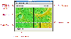
 A volume of data with map names, map numbers, corner coordinates and completing data of all official topographic maps of the Federal Republic of Germany. TK25: Data base table with data of the maps on a scale 1:25000. TK50: Table with data of the maps on a scale 1:50000. TK100: Table with data of...
Platforms: All
| License: Freeware | Size: 51.2 KB | Download (51): Geodaten German Topo Download |
Added: May 10, 2013 | Visits: 323
Knowledge Management WebService for Venezuelan Goverment Institution named INZIT-CICASI, the general objetive on which this webservice relies on is an administrative information system for management, registering and general control of experiment samples and other stuff made in its projects.
Platforms: Windows, *nix, PHP, BSD Solaris
| License: Freeware | Download (50): inzit-cicasi-sys Download |
Released: August 01, 2012
|
Added: August 01, 2012 | Visits: 643
 Thousands of people might know well about Excel, they play it as a daily tool in their work. However, the datas between each single Excel are normally unable to repeat, exchange and share theirselves automatically. If we consider Excel as brick, then a house will not be built without laying...
Platforms: Windows
| License: Freeware | Size: 89.34 MB | Download (50): BC Excel Server 2008 Standard-Complete Download |
Released: July 04, 2012
|
Added: July 04, 2012 | Visits: 638
Window Information (TWindowInformation component) is a useful utility that gives you the possibility to find any window in the system and analyze it with VCL-friendly TWindow class which allow to access window data with simple VCL-friendly properties.
All you need to find the window is to set...
Platforms: Windows
| License: Freeware | Download (50): Window Information Download |
Released: August 27, 2012
|
Added: August 27, 2012 | Visits: 302
A platform & DB-independent method for receiving job or volunteer application online and subsequently evaluating and managing them. Developed by Oxfam Australia for the Humanitarian Relief Register: http://www.caa.org.au/helping/work/relief/index.html
Platforms: Windows, Mac, Linux
| License: Freeware | Size: 318.05 KB | Download (49): Emergenices Personnel Information System Download |
Released: August 08, 2012
|
Added: August 08, 2012 | Visits: 374
GIT is an open source library that operates image transcoding for mobile applications. GaWis is an open source information system for the creation, management and use of a customizable information source about mobile devices.
Platforms: Windows, Mac, Linux
| License: Freeware | Size: 30.85 MB | Download (49): GIT and GaWis Download |
Released: July 12, 2012
|
Added: July 12, 2012 | Visits: 519
Java Information Retrieval System (JIRS) is an information retrieval system based on passages. This system has the advantage of being able to change to the different modules from the system and their functionality modifying the configuration XML file
Platforms: Windows, Mac, Linux
| License: Freeware | Size: 7.84 MB | Download (49): Java Information Retrieval System Download |
Added: June 12, 2013 | Visits: 732
This book is designed for an advanced course and is a companion volume to the introductory text, Modern Control System Theory and Design, 2e. In addition, it can serve as a text for practicing control system engineers who need to learn more advanced control systems techniques in order to perform...
Platforms: Matlab
| License: Freeware | Size: 757.76 KB | Download (49): Advanced Modern Control System Theory and Design Download |
Released: September 01, 2012
|
Added: September 01, 2012 | Visits: 535
New Zealand Distributed Information Systems (NZDIS)
Distributed, heterogenous, agent-based framework for intelligent/semantic information and services integration.
Platforms: Windows, Mac, Linux
| License: Freeware | Size: 118.49 KB | Download (48): Distributed Information System (NZDIS) Download |
Added: July 27, 2013 | Visits: 616
OpenSIS, is a free student information system that rivals costly commercial alternatives in looks, functionality, ease of use and administration.OpenSIS is the centerpiece of an evolving set of integrated open source education applications that support schools and districts. openSIS is a game...
Platforms: PHP
| License: Freeware | Size: 2.2 MB | Download (48): openSIS Community Edition Download |
Released: June 08, 2012
|
Added: June 08, 2012 | Visits: 444
Mapyrus is software to plot Geographic Information System data to PostScript, PDF, SVG and web image files. Mapyrus combines a BASIC-like scripting language, reading GIS datasets and running as either a utility program, a Java Servlet, or as a webser
Platforms: Windows, Mac, Linux
| License: Freeware | Size: 3.27 MB | Download (48): mapyrus Download |
Released: July 17, 2012
|
Added: July 17, 2012 | Visits: 480
 JMARS is an acronym that stands for Java Mission-planning and Analysis for Remote Sensing. It is a geospatial information system (GIS) developed by ASU's Mars Space Flight Facility to provide mission planning and data-analysis tools to NASA's orbiters, instrument team members, students of all...
Platforms: Windows, Mac, Linux
| License: Freeware | Size: 52.2 MB | Download (48): JMARS Download |
Released: November 01, 2012
|
Added: November 01, 2012 | Visits: 525
Archon is an award-winning web application used for managing and publishing archival descriptive information and digital archival objects in a user-friendly website and generating corresponding EAD and MARC records.
Platforms: Windows, Mac, Linux
| License: Freeware | Size: 32.95 MB | Download (47): Archon: Archival Information System Download |
Released: August 21, 2012
|
Added: August 21, 2012 | Visits: 510
This Resource Adapter enables you to connect your Java application to the 1C Enterprise Information System based on ActiveX and MS SQL Server. It should be compliant to JCA 1.0
Platforms: Windows, Mac, Linux
| License: Freeware | Size: 10.31 KB | Download (47): JCA Resource Adapter for 1C EIS System Download |