


Gpx freeware
Gpx
Added: September 09, 2010 | Visits: 2.503
 Geo::Gpx is a Perl module to create and parse GPX files. SYNOPSIS # Version 0.10 compatibility use Geo::Gpx; my $gpx = Geo::Gpx->new( @waypoints ); my $xml = $gpx->xml; # New API, generate GPX my $gpx = Geo::Gpx->new(); $gpx->waypoints(@wpt); my $xml = $gpx->xml(1.0); # Parse GPX...
Platforms: *nix
| License: Freeware | Size: 12.29 KB | Download (214): Geo::Gpx Download |
Released: June 20, 2012
|
Added: June 20, 2012 | Visits: 780
GPX and TCX file welder is a small, easy to use application specially designed to help you substitute the missing GPS information in Garmin TCX files when devices lacking a GPS receiver are used to collect training data (Garmin FR 60, heartrate and pedometer only).
This application is also...
Platforms: Windows
| License: Freeware | Download (425): GPX and TCX file welder Download |
Released: September 08, 2009
|
Added: September 14, 2009 | Visits: 3.871
 PhotoGPSEditor is an easy to use meta-data editor for photo (JPEG, RAW) files, plus it can match data from GPS (gpx or NMEA) files. The program is freeware, however, donations can be made to help support future development. With PhotoGPSEditor you can add location and summary details to a...
Platforms: Mac
| License: Freeware | Size: 2.39 MB | Download (1330): PhotoGPSEditor Download |
Released: January 14, 2010
|
Added: January 16, 2010 | Visits: 3.960
![]() The Picmeta Photo Tracker automatically geotags photos based on track information from any GPS device (.gpx files). It directly writes GPS EXIF data to .jpg, .tif, .crw, .dng, .nef, .pef, .jp2 formats. For other formats such as .cr2 it creates XMP sidecar files. The EXIFcare technology ensures...
The Picmeta Photo Tracker automatically geotags photos based on track information from any GPS device (.gpx files). It directly writes GPS EXIF data to .jpg, .tif, .crw, .dng, .nef, .pef, .jp2 formats. For other formats such as .cr2 it creates XMP sidecar files. The EXIFcare technology ensures...
Platforms: Windows
| License: Freeware | Size: 2.18 MB | Download (192): Picmeta Photo Tracker Download |
Released: March 01, 2010
|
Added: April 22, 2010 | Visits: 2.515
Mapyx Quo is an intuitive, easy to learn and, surprisingly simple-to-use digital mapping program which enables you to connect your GPS to your PC and manage all your waypoints, routes and tracks. View information such as elevation, distance, speed, ETA and many more. Quo supports numerous...
Platforms: Windows, Windows CE
| License: Freeware | Size: 44.95 MB | Download (7377): Mapyx Quo Download |
Released: July 04, 2012
|
Added: July 04, 2012 | Visits: 389
 GUI for convert Navi Gpx Files to HTML, XML or CSV include Java API
Platforms: Windows, Mac, Java, Linux, Linux Console, Linux Gnome, Linux GPL, Linux Open Source, Unix, Other
| License: Freeware | Size: 1.77 MB | Download (510): TWGpx Download |
Added: June 28, 2013 | Visits: 365
gpx2map reads a gps track in GPX format (as produced by e.g. gpsbabel) and writes out an Google Map or or OpenStreetMaps mash-up containing the route and a height profile. gpx2map can also show GPS-tagged photos along the map. Installation Just copy (or link) the file gpx2map into your path or...
Platforms: *nix
| License: Freeware | Size: 92.16 KB | Download (45): gpx2map Download |
Added: January 25, 2010 | Visits: 1.033
TrailRunner is a route planning software for all kinds of long distance sports like running, biking, hiking, inline-skating, skiing and more. If you ever asked yourself how long your workout routes are and what route you should choose for this evening - then TrailRunner should be your...
Platforms: Mac
| License: Freeware | Download (123): TrailRunner Download |
Released: January 25, 2010
|
Added: August 18, 2010 | Visits: 1.059
 Set of programs to convert GPS-tracks of *.gpx, *.mps, *.plt or *.nmea format to route files *.rt2. Software creates two route files - forward route and backward one.
Platforms: Windows
| License: Freeware | Size: 26.06 KB | Download (878): Gpx2rt2 Download |
Released: January 20, 2012
|
Added: March 05, 2013 | Visits: 847
 A program to convert GPS-track of *.gpx, *.mps, *.plt or *.nmea format to Navitel Tracks.bin "blue line" file.
Platforms: Windows
| License: Freeware | Size: 31.64 KB | Download (623): Gpx2bin Download |
Released: May 28, 2012
|
Added: July 18, 2012 | Visits: 1.069
 RouteConverter displays, modifies, enriches and converts GPS data between over 75 formats. It works without installation under Linux, Mac OS X and Windows, automatically detects the format of a file, supports drag and drop, undo and redo, offers a map view onto the positions of routes, tracks and...
Platforms: Windows, Mac, *nix, Windows 7, Solaris,FreeBSD,OpenBSD,Java
| License: Freeware | Size: 6.61 MB | Download (162): RouteConverter Download |
Released: July 21, 2012
|
Added: July 21, 2012 | Visits: 460
![]() Picmeta PhotoTracker automatically geotags photos based on track information from any GPS device (.gpx files). It directly writes GPS EXIF data to .jpg, .tif, .crw, .dng, .nef, .pef, .jp2 formats. For other formats such as .cr2 it creates XMP sidecar files. The EXIFcare technology ensures that...
Picmeta PhotoTracker automatically geotags photos based on track information from any GPS device (.gpx files). It directly writes GPS EXIF data to .jpg, .tif, .crw, .dng, .nef, .pef, .jp2 formats. For other formats such as .cr2 it creates XMP sidecar files. The EXIFcare technology ensures that...
Platforms: Windows
| License: Freeware | Size: 2.36 MB | Download (387): Picmeta PhotoTracker Download |
Released: July 01, 2012
|
Added: July 01, 2012 | Visits: 753
 Atom GPS freeware easily geotags your photos directly from your GPS device or track log. By simply connecting your GPS Device to Atom GPS and selecting your photos you can add their geolocation in one click. This action allows you to write the geolocation data to your photos exifs (information...
Platforms: Windows
| License: Freeware | Size: 7.58 MB | Download (424): ATOM GPS Download |
Released: October 11, 2012
|
Added: October 11, 2012 | Visits: 538
A utility for uploading, downloading, and transcoding GPS data among GPS devices, GPX files, and KML files (for Google Earth). The resulting files can be used in a variety of applications available for the Macintosh, including TrackRunner, TrailRunner, and of course Google Earth.
Use...
Platforms: Mac
| License: Freeware | Size: 1.8 MB | Download (483): LoadMyTracks for Mac OS Download |
Released: September 25, 2012
|
Added: September 25, 2012 | Visits: 555
An easy to use meta-data editor for photo (JPEG, RAW) files, plus it can match data from GPS (gpx or NMEA) files. The program is freeware, however, donations can be made to help support future development.
With PhotoGPSEditor you can add location and summary details to a JPEG/RAW photo files....
Platforms: Mac
| License: Freeware | Size: 2.4 MB | Download (440): PhotoGPSEditor for Mac OS Download |
Released: August 21, 2012
|
Added: August 21, 2012 | Visits: 599
Tool to extract data from a GlobalSat DG-100 GPS data logger and store the data in GPX format. It also can send configuration data to the device, delete stored data and switch the device to GPS-mouse mode.
Platforms: Windows, Mac, Linux
| License: Freeware | Size: 20.22 KB | Download (46): DG100 Util Download |
Released: June 11, 2012
|
Added: June 11, 2012 | Visits: 377
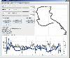 This program takes NMEA, CSV, GPR or GPX logfiles from your GPS device, manages your tracks and exports them as KML to Google Earth. Investigate altitude and speed information, measure distances and cut tracks.
Platforms: Windows, Mac, Linux
| License: Freeware | Size: 1.77 MB | Download (46): GpRoko - Track Analyzer Download |
Released: June 19, 2012
|
Added: June 19, 2012 | Visits: 198
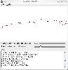 A program for cropping GPX track files. The GUI plots the GPX track (latitude vs longitude) and lets the user remove GPS points from the beginning and end of the track respectively. There is also a built-in Command Line Interface.
Platforms: Windows, Mac, Linux
| License: Freeware | Size: 72.29 KB | Download (45): GPXTrackCropper Download |
Released: August 05, 2012
|
Added: August 05, 2012 | Visits: 156
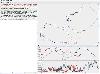 A library written in Java to manipulate GPX files. Also contained is a GUI program to visualize GPX files and the effects of manipulating them.
Platforms: Windows, Mac, Linux
| License: Freeware | Size: 87.7 KB | Download (44): JGPXtool Download |
Released: September 16, 2012
|
Added: September 16, 2012 | Visits: 352
The suite of Python-based shell tools for geocoding images from GPS logs (GPX)
Platforms: Windows, Mac, Linux
| License: Freeware | Size: 31.02 KB | Download (44): pygeotag Download |