


Geoscience freeware
Geoscience
Released: September 26, 2012
|
Added: September 26, 2012 | Visits: 534
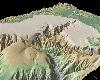 GeoMapApp is an earth science exploration and visualization application that is continually being expanded as part of the Marine Geoscience Data System (MGDS) at the Lamont-Doherty Earth Observatory of Columbia University.
The application provides direct access to the Global Multi-Resolution...
GeoMapApp is an earth science exploration and visualization application that is continually being expanded as part of the Marine Geoscience Data System (MGDS) at the Lamont-Doherty Earth Observatory of Columbia University.
The application provides direct access to the Global Multi-Resolution...
Platforms: Windows
| License: Freeware | Size: 9 MB | Download (446): GeoMapApp Download |
Added: September 07, 2013 | Visits: 497
 Earthquake Risk Model (EQRM) is capable of earthquake scenario ground motion and scenario loss modeling as well as probabilistic seismic hazard (PSHA) and risk (PSRA) modeling. It is a product of Geoscience Australia an Australian Government Agency.
Platforms: *nix
| License: Freeware | Size: 317.44 KB | Download (59): EQRM Download |
Released: July 08, 2012
|
Added: July 08, 2012 | Visits: 412
 IDL and ENVI software tools for opening, viewing, filtering, and analyzing Mal Geoscience RAMAC ground-penetrating radar (GPR) data.
Platforms: Windows, Mac, Linux
| License: Freeware | Size: 102.39 KB | Download (47): GPR IDL tools Download |
Added: November 03, 2010 | Visits: 880
ANUGA is a software implementation of a hydrodynamic model that is specifically designed to model wetting and drying processes.. Get ANUGA - Hydrodynamic Modelling at SourceForge.net. Fast, secure and free downloads from the largest Open Source applications and software directory. ANUGA is a...
Platforms: *nix
| License: Freeware | Size: 3.5 MB | Download (101): ANUGA 1.0 Beta Download |