


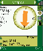
Garmin Geocaching freeware
Garmin Geocaching
Released: March 01, 2010
|
Added: April 22, 2010 | Visits: 2.514
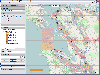
 Mapyx Quo is an intuitive, easy to learn and, surprisingly simple-to-use digital mapping program which enables you to connect your GPS to your PC and manage all your waypoints, routes and tracks. View information such as elevation, distance, speed, ETA and many more. Quo supports numerous...
Platforms: Windows, Windows CE
| License: Freeware | Size: 44.95 MB | Download (7377): Mapyx Quo Download |
Added: August 31, 2008 | Visits: 3.343
GeoVisu is a visualization software for geographic data - graphic files, images and GPS. It provides real time GPS navigation (moving map - NMEA 0183 protocol or Garmin USB), displayed with diverse geographic data (MIF, GPX, NMEA, KML/KMZ, SHP, ECW, GeoTiff, MrSID). It can download waypoints,...
Platforms: Windows
| License: Freeware | Size: 1.5 MB | Download (1383): GeoVisu Download |
Released: December 29, 2010
|
Added: January 06, 2011 | Visits: 4.313
 OkMap is a GPS and map software that:
-Works with vectorial maps and calibrates raster maps
-Organizes paths by creating waypoints, routes and tracks
-Uploads/downloads data to/from your GPS
-Uses altitude DEM data
-Supports GPS real-time navigation
-Sends/receives vehicles position...
OkMap is a GPS and map software that:
-Works with vectorial maps and calibrates raster maps
-Organizes paths by creating waypoints, routes and tracks
-Uploads/downloads data to/from your GPS
-Uses altitude DEM data
-Supports GPS real-time navigation
-Sends/receives vehicles position...
Platforms: Windows
| License: Freeware | Size: 20.25 MB | Download (1271): OkMap Download |
Added: August 04, 2008 | Visits: 2.755
This free program allows you to plan and record your trips with a GPS receiver and share your local knowledge of trails with others, you can also use the program to print topographic maps with these trails, either on a single page or, as a mosaic, on many sheets of paper. GPS Mapping Sofware...
Platforms: Windows
| License: Freeware | Size: 1024 KB | Download (626): Wissenbach Map Download |
Released: November 16, 2012
|
Added: November 16, 2012 | Visits: 485
 Provides hours of entertainment by combining the technology in your phone with one of the fastest-growing international hide and seek games - geocaching (also known as "GPS treasure hunt"). By using your Nokia's GPS and built-in Internet, Geocache Navigator™ creates a seamless and exciting...
Platforms: Handheld/Mobile Other, Java
| License: Freeware | Size: 225.28 KB | Download (528): Geocache Navigator Download |
Released: November 23, 2012
|
Added: November 23, 2012 | Visits: 256
With OpenStreetMap.org, you can export maps (for free) in XML OSM format. These maps are pretty handy - but if you want to load them onto your GPS, this free utility will allow you to easily convert the OSM files to IMG files which you can import into your Garmin GPS.
Platforms: Mac
| License: Freeware | Size: 2.5 MB | Download (511): OSMtoIMG for Mac OS Download |
Released: January 11, 2013
|
Added: January 11, 2013 | Visits: 726
 Super GPS Store Search Helps You Find The Best Deals On GPS's Search though thousands of GPS related products with ease. Shopping Secured By Amazon.com All this in this free application, requires no install, has no adware or spyware.
Platforms: Windows
| License: Freeware | Size: 756 KB | Download (511): Super GPS Store Search Software Download |
Released: October 11, 2012
|
Added: October 11, 2012 | Visits: 598
QLandkarte GT is a handy, easy to use program specially designed to offer users a ultimate outdoor aficionado's tool.
This application offers support for GPS maps in GeoTiff format as well as Garmin's img vector map format.
for WindowsXP, Vista, 7
Platforms: Windows, Windows Vista, 7
| License: Freeware | Download (498): QLandkarte GT Download |
Released: November 26, 2012
|
Added: November 26, 2012 | Visits: 546
Let this software and a GPS logger do the hard work of assigning precise Places metadata to your photos. Why import ungeotagged pictures into iPhoto, when its so straightforward to GPS-enable your favorite camera?
Geotagalogs sophisticated automatic geotagging technology combines locations from...
Platforms: Mac
| License: Freeware | Size: 13.8 MB | Download (498): Geotagalog for Mac OS Download |
Released: October 22, 2012
|
Added: October 22, 2012 | Visits: 419
An intuitive geocache management and planning tool. Manage all your Geocaches from one place. Send only the caches you want to your GPS receiver. When you're done Geocaching, download them to Geocache Manager to automatically update your finds. Import Geocaches from queries, .loc or .gpx files....
Platforms: Mac
| License: Freeware | Size: 5 MB | Download (497): Geocache Manager for Mac OS Download |
Released: October 08, 2012
|
Added: October 08, 2012 | Visits: 833
ITN Converter Travel is both a route converter supporting many formats and a simple and efficient route planner. The converter supports routes file formats (roadbook) from many GPS or mapping software, the most popular are TomTom, Navigon, Garmin, MapPoint or MapSource. This converter can easily...
Platforms: Windows
| License: Freeware | Download (492): ITN Converter Travel Download |
Released: September 07, 2012
|
Added: September 07, 2012 | Visits: 474
A powerful and flexible journal application that allows all levels of athletes and fitness enthusiasts to get the most from their training and racing. It allows you to easily and quickly track your training, monitor your progress, and built a history of your training. You can manually enter your...
Platforms: Mac
| License: Freeware | Size: 20 MB | Download (485): iSMARTtrain for Mac OS Download |
Released: October 11, 2012
|
Added: October 11, 2012 | Visits: 538
A utility for uploading, downloading, and transcoding GPS data among GPS devices, GPX files, and KML files (for Google Earth). The resulting files can be used in a variety of applications available for the Macintosh, including TrackRunner, TrailRunner, and of course Google Earth.
Use...
Platforms: Mac
| License: Freeware | Size: 1.8 MB | Download (483): LoadMyTracks for Mac OS Download |
Released: August 14, 2012
|
Added: August 14, 2012 | Visits: 692
Works as a diary for your gear. Although it is fully customizable, it is designed to track use of sports gear like running shoes, bicycles, bike parts, etc. Sports Equipment Log integrates with Garmin wireless Fitness devices, and imports activities - so mileages, dates, and activity types are...
Platforms: Mac
| License: Freeware | Size: 348.16 KB | Download (481): Sports Equipment Log for Mac OS Download |
Released: July 10, 2012
|
Added: July 10, 2012 | Visits: 605
An activity tracking and exercise journal software for the Mac. It lets you display, analyze and organize your indoor and outdoor workouts for sports such as running, biking, walking, hiking, skiing and many more.
rubiTrack reads tracks from GPS enabled fitness devices like the Garmin Forerunner...
Platforms: Mac
| License: Freeware | Size: 5.4 MB | Download (467): rubiTrack for Mac OS Download |
Released: September 04, 2012
|
Added: September 04, 2012 | Visits: 749
 Mobile Atlas Creator (formerly known as TrekBuddy Atlas Creator) is an open source (GPL) program which creates offline atlases for GPS handhelds and cell phone applications like TrekBuddy, AndNav and other Android and WindowsCE based applications.
For the full list of supported applications...
Mobile Atlas Creator (formerly known as TrekBuddy Atlas Creator) is an open source (GPL) program which creates offline atlases for GPS handhelds and cell phone applications like TrekBuddy, AndNav and other Android and WindowsCE based applications.
For the full list of supported applications...
Platforms: Mac
| License: Freeware | Size: 1.6 MB | Download (448): Mobile Atlas Creator for Mac OS X Download |
Released: June 20, 2012
|
Added: June 20, 2012 | Visits: 780
GPX and TCX file welder is a small, easy to use application specially designed to help you substitute the missing GPS information in Garmin TCX files when devices lacking a GPS receiver are used to collect training data (Garmin FR 60, heartrate and pedometer only).
This application is also...
Platforms: Windows
| License: Freeware | Download (424): GPX and TCX file welder Download |
Released: July 12, 2012
|
Added: July 12, 2012 | Visits: 485
 ITN Converter is both a route converter supporting many formats and a simple and efficient route planner. The converter supports routes file formats (roadbook) from many GPS or mapping software, the most popular are TomTom, Navigon, Garmin, MapPoint or MapSource. This converter can easily...
Platforms: Windows
| License: Freeware | Download (414): ITN Converter Portable Download |
Released: July 16, 2012
|
Added: July 16, 2012 | Visits: 467
 ITN Converter is both a route converter supporting many formats and a simple and efficient route planner. The converter supports routes file formats (roadbook) from many GPS or mapping software, the most popular are TomTom, Navigon, Garmin, MapPoint or MapSource. This converter can easily...
Platforms: Windows
| License: Freeware | Download (406): ITN Converter Download |
Released: July 19, 2012
|
Added: July 19, 2012 | Visits: 828
 Mobile Atlas Creator (formerly known as TrekBuddy Atlas Creator) is an open source (GPL) program which creates offline atlases for GPS handhelds and cell phone applications like TrekBuddy, AndNav and other Android and WindowsCE based applications.
For the full list of supported applications...
Mobile Atlas Creator (formerly known as TrekBuddy Atlas Creator) is an open source (GPL) program which creates offline atlases for GPS handhelds and cell phone applications like TrekBuddy, AndNav and other Android and WindowsCE based applications.
For the full list of supported applications...
Platforms: Windows
| License: Freeware | Size: 2 MB | Download (398): Mobile Atlas Creator Download |