


Flash Map Display freeware
Flash Map Display
Released: May 01, 2011
|
Added: May 23, 2011 | Visits: 1.402
 Convert ESRI ShapeFiles (.SHP) geolocation data into AnyMap format to be used with AnyChart. AnyChart Flash Map Converter allows making use of a wide choice of maps with AnyChart Flash Component, a GIS visualization system that recognizes map data in AnyMap format only. AnyChart Flash Map...
Platforms: Windows
| License: Freeware | Size: 1.62 MB | Download (126): AnyChart Flash Map Converter Download |
Released: January 17, 2013
|
Added: January 17, 2013 | Visits: 707
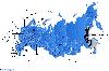 Dongsoft Interactive Russia Flash Maps for websites, interactive map applications, presentations, and more. The innovation of this fully-clickable map will revolutionize your website navigation and provide visitors with a simple and seamless method of accessing information. Using the map as a...
Platforms: Windows, Mac, Linux
| License: Freeware | Size: 156 KB | Download (51): Free Russia Flash Map Download |
Released: January 18, 2013
|
Added: January 18, 2013 | Visits: 815
 Dongsoft Interactive India Flash Maps for websites, interactive map applications, presentations, and more. The innovation of this fully-clickable map will revolutionize your website navigation and provide visitors with a simple and seamless method of accessing information. Using the map as a...
Platforms: Windows, Mac, Linux
| License: Freeware | Size: 156 KB | Download (45): Free India Flash Map Download |
Released: January 08, 2013
|
Added: January 08, 2013 | Visits: 714
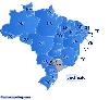 Dongsoft Interactive Brazil Flash Maps for websites, interactive map applications, presentations, and more. The innovation of this fully-clickable map will revolutionize your website navigation and provide visitors with a simple and seamless method of accessing information. Using the map as a...
Platforms: Windows, Mac, Linux
| License: Freeware | Size: 156 KB | Download (47): Free Brazil Flash Map Download |
Released: August 06, 2012
|
Added: August 06, 2012 | Visits: 598
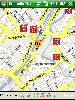
 City Walks Online (CWO) is an interactive Flash map viewer. CWO features a scrollable map, search-and-find for locating points of interest, and the ability to show photos and videos.
City Walks Composer is a handy, easy to use application specially designed to help you build Flash tours. You...
City Walks Online (CWO) is an interactive Flash map viewer. CWO features a scrollable map, search-and-find for locating points of interest, and the ability to show photos and videos.
City Walks Composer is a handy, easy to use application specially designed to help you build Flash tours. You...
Platforms: Windows
| License: Freeware | Size: 1013.76 KB | Download (438): City Walks Composer Download |
Added: November 09, 2010 | Visits: 936
PostArabic project is used to provide Arabic shaping for the map display in DCMMS. The PostArabic package provides Arabic shaping functionality for PostgreSQL. PostArabic is available from http://dcmms.sourceforge.net. The package adds the following functions to PostgreSQL: text...
Platforms: *nix
| License: Freeware | Size: 31.74 KB | Download (111): PostArabic Download |
Released: December 06, 2012
|
Added: December 06, 2012 | Visits: 500
WNMap is a wireless network map display based on Google Map. Once installed network 'nodes' can be added to the map's database and can be shown for web visitors. WNMap provides at-a-glance knowledge of a wireless network project's size. WNMap is
Platforms: Windows, Mac, Linux
| License: Freeware | Size: 39.1 KB | Download (48): WNMap Download |
Released: July 25, 2012
|
Added: July 25, 2012 | Visits: 1.213
Character Map is a compact application that allows you to view the characters for a selected font, making it easy to select and paste any character into your current document.
The program is very useful if you are constantly working with special characters and you do not have the time to search...
Platforms: Windows
| License: Freeware | Download (411): Character Map Download |
Added: May 10, 2013 | Visits: 478
easyMap is a module written in PHP which allows you to display a map (or any other image for that matter) with markings superimposed on top of it.The module allows full graphical management of multiple maps, with numerous markings for each map. Markings are also arranged by categories, thus a...
Platforms: Windows, Mac, *nix, PHP, BSD Solaris
| License: Freeware | Download (61): easyMap Download |
Added: November 21, 2013 | Visits: 382
lizard-map is a software that provides basic map interaction for Django applications that use a lizard-ui user interface. We designed it at Nelen & Schuurmans for our geographical information websites (with water management information). It provides: * Openlayers (map javascript libary) map...
Platforms: *nix
| License: Freeware | Size: 2.01 MB | Download (39): lizard-map Download |
Added: January 20, 2013 | Visits: 493
Just stick a simple div in the content with some special attributes and a Google Map will be displayed at that point.div class="GMapEZ GSmallMapControl" style="width: 600px; height: 480px;"The latitude/longitude or an address can be specified.InstallationUnpack in your modules folder (usually...
Platforms: BSD Solaris
| License: Freeware | Download (55): GMapEZ 6.x- / 5.x- Download |
Added: February 16, 2013 | Visits: 468
Just stick a simple div in the content with some special attributes and a Google Map will be displayed at that point.div class="GMapEZ GSmallMapControl" style="width: 600px; height: 480px;"The latitude/longitude or an address can be specified.InstallationUnpack in your modules folder (usually...
Platforms: BSD Solaris
| License: Freeware | Download (56): GMapEZ 6.x- / 5.x- Download |
Added: May 10, 2013 | Visits: 377
25 different flash clocks are included. Installation Unpack and upload it to the /wp-content/plugins/ directory. Activate the plugin through the 'Plugins' menu in WordPress. Requirements: - WordPress 2.3 or higher
Platforms: Windows, Mac, *nix, PHP, BSD Solaris
| License: Freeware | Download (54): WP-FlashTime Widget Download |
Added: October 10, 2013 | Visits: 563
Landscape photographers typically wish to plan their shoots around the times of sunset/sunrise or twilight, or alternatively when the moon is in a particular place in a particular phase. While times of sunrise etc. are readily available on various sites on the internet (direction of sunrise etc....
Platforms: Mac
| License: Freeware | Size: 2.25 MB | Download (52): The Photographer's Ephemeris Download |
Released: October 23, 2012
|
Added: October 23, 2012 | Visits: 651
GPS Utility is an easy-to-use application that provides management and manipulation of GPS information. You can use it to transfer data to/from a GPS receiver and store the data in PC files in one of several text formats.
The program converts between different map datums and many coordinate...
Platforms: Windows
| License: Freeware | Size: 1.87 MB | Download (469): GPS Utility Download |
Released: November 11, 2012
|
Added: November 11, 2012 | Visits: 509
 News, feature articles and reviews, lessons, and questions answered. A musical keyboard is the set of adjacent depressible levers or keys on a musical instrument, particularly the piano. . Music lessons are a type of formal instruction in playing a musical instrument or singing Typically, a...
Platforms: All
| License: Freeware | Size: 163.84 KB | Download (48): Dancing bug Download |
Released: July 22, 2012
|
Added: July 22, 2012 | Visits: 461
 Use your Windows Pocket PC in combination with www.geopolix.com and you can share your geographical location with friends, family, business colleagues and every other community you can think of. It is completely up to you to share your location whenever, wherever and with whomever you want. If...
Platforms: Windows
| License: Freeware | Size: 773 KB | Download (524): Geopolix Client Download |
Released: June 01, 2012
|
Added: June 01, 2012 | Visits: 332
Infocat 3.0 is a PHP/MySQL/XHTML/Flash News Display. Integrated with the Open Source Joomla! CMS system, Infocat 3.0 will allow users to log in and save announcements, and a seperate display page will load and display the announcements using Flash and tr
Platforms: Windows, Mac, Linux
| License: Freeware | Size: 2.97 MB | Download (47): Infocat 3.0 Download |
Released: July 07, 2012
|
Added: July 07, 2012 | Visits: 281
jDip is a tool for mapping, managing, and adjudicating Diplomacy games. It has a simple but powerful graphical interface, with a richly customizable map display. Windows, Linux, Mac OS X, and Solaris are supported. Over 25 variants are supported.
Platforms: Windows, Mac, BSD, Solaris, Linux
| License: Freeware | Size: 6.42 MB | Download (50): jDip: A Diplomacy Mapper and Judge Download |
Added: June 19, 2013 | Visits: 431
GeoContacts is a geoencoding address book plugin with Gravatar and template support. GeoContacts will display single contacts or your whole address book in your posts. No other address book plugin can do everything GeoContacts does. The Google API is used to geocode and Google maps are used to...
Platforms: PHP
| License: Freeware | Size: 10 KB | Download (52): GeoContacts Download |