


Coordinates freeware
Coordinates
Added: April 12, 2013 | Visits: 486
 It performs transformations of geodetic coordinates from one ellipsoid to another using 7 datum parameters. It is also called Helmert 7 parameters transformation or datum transformation (in geodesy and cartography).
Platforms: Matlab
| License: Freeware | Size: 10 KB | Download (39): Datum Transformation Download |
Added: August 02, 2013 | Visits: 429
A variation of Matlab's cart2sph, that transforms a vector of Cartesian coordinates (East, North, Up) to radar coordinates (Range, Azimuth, Elevation). Note the different definition of radar coords vs. spherical coords, which require this different function (see exact definitions within the help...
Platforms: Matlab
| License: Freeware | Size: 10 KB | Download (44): xyz2rae Download |
Added: April 06, 2013 | Visits: 454
returns a set of 2D coordinates from a 3D triangulated surface. 2D points are disposed inside a circle of unit radius so they represent a parametrization of the initial surface.The triangulation is represented by the n x 3 t array.In t are stored the triangles of the initial surface with first...
Platforms: Matlab
| License: Freeware | Size: 2.98 MB | Download (49): SURFACE PARAMETRIZER Download |
Added: April 30, 2013 | Visits: 468
distributes points around a given point on a through a normal determined plane and gives their coordinates back
Platforms: Matlab
| License: Freeware | Size: 10 KB | Download (39): circle_Points_Distr Download |
Added: July 30, 2013 | Visits: 390
IMAGE2SPREADSHEET allows the user to browse through several pictures in one folder and collect pixel coordinates from each picture.Use the arrows to navigate through the pictures and press 'space' to collect coordinates.
Platforms: Matlab
| License: Freeware | Size: 10 KB | Download (42): Image2spreadsheet Download |
Added: July 14, 2013 | Visits: 497
Function that convert geographic coordinates to North azimuthal equal-area map with 25 kmresolution pixel (EASE-Grid projection or NL). That projection is used mainly in remote sensing and cover the northern hemisphere.If you want to know the corresponding pixel in the EASE-Grid projection to a...
Platforms: Matlab
| License: Freeware | Size: 10 KB | Download (47): geo2easeGrid Download |
Added: June 13, 2013 | Visits: 376
Generate a Cartesian coordinates of the cubed-sphere of radius 1the grid is gnomonic equiangular/equidistance central projectionInspired from this thread http://www.mathworks.com/matlabcentral/new...w_thread/258457
Platforms: Matlab
| License: Freeware | Size: 368.64 KB | Download (46): Cubed sphere Download |
Added: August 18, 2013 | Visits: 411
The module makes it possible for other module developers easily to use Yahoo Geocoding API to find geo coordinates for a given address.The module it self don't do anything out of the box, by provides a function to find the geo coordinates.
Platforms: PHP
| License: Freeware | Size: 10 KB | Download (52): Yahoo Geocoding API Download |
Added: April 19, 2013 | Visits: 457
EPSA Crop is a module that allows a user to choose coordinates for different presets on an image. If a user defines coordinates EPSACrop will override the Imagecache process and will set new coordinates.Every preset with the crop action is handled by EPSACrop. If the user don't change the...
Platforms: PHP
| License: Freeware | Size: 20.48 KB | Download (52): EPSA Crop - Image Cropping Download |
Added: November 05, 2013 | Visits: 759
Easy-to-use 3D grapher that plots high quality graphs for 2D and 3D functions and coordinates tables. Graphing equations is as easy as typing them down. Graphs are beautifully rendered with gradual colors and lighting and reflection effects. Both cartesian and polar coordinates are supported as...
Platforms: *nix, Java, Linux Console, Linux Open Source, Linux Gnome
| License: Freeware | Size: 7.71 MB | Download (41): Advanced Graphing Calculator 3D Linux Download |
Released: July 30, 2023
|
Added: August 09, 2023 | Visits: 198
 Sea battle online: a game for two participants. This is a computer game that uses a permanent Internet connection. This is an online battle in which players take turns shooting at coordinates on the opponent's map. If the enemy has a "ship" on the map, then the ship or its deck (square) is killed...
Platforms: Windows, Windows 7, Windows Server, Other
| License: Freeware | Size: 2.96 MB | Download (21): Battleships Online Download |
Released: April 24, 2013
|
Added: May 12, 2013 | Visits: 2.304
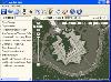 Arm Map Explorer recreates all the functionalities of Google Maps on your desktop while expanding them with new extras. Map Explorer lets you locate and view any place on the planet using dynamic interactive maps. These maps are draggable, which means there is no need for you to click and wait...
Platforms: Windows
| License: Freeware | Size: 5.46 MB | Download (197): Arm Map Explorer Download |
Added: August 03, 2008 | Visits: 906
Abykus is an object-oriented spreadsheet for Windows that adds an exciting new dimension to the classic 'what-if' analysis by allowing complex data types such as matrixes, coordinates, polygons, etc. to be stored in individual cells. Ideally suited for engineering, surveying and other scientific...
Platforms: Windows
| License: Freeware | Size: 573 KB | Download (104): Abykus Download |
Added: August 09, 2008 | Visits: 1.290
Gauss displays lines and surfaces defined algebraically in 3D space in many forms, including z=f(x,y), cylindrical polar coordinates, and parametric definitions with one (giving a line) and two (surface) parameters. View controls move the viewpoint through 3D space, using keyboard and mouse....
Platforms: Windows
| License: Freeware | Size: 962 KB | Download (217): Gauss Download |
Released: May 28, 2010
|
Added: June 04, 2010 | Visits: 2.695
 Copan for Windows desktop/netbook is a very functional and easy-to-use geomatics engineering tool for computing and managing plane land surveying and mapping coordinates.
It does numerous coordinate geometry (COGO) calculations, processes and adjusts raw field survey data, computes and...
Copan for Windows desktop/netbook is a very functional and easy-to-use geomatics engineering tool for computing and managing plane land surveying and mapping coordinates.
It does numerous coordinate geometry (COGO) calculations, processes and adjusts raw field survey data, computes and...
Platforms: Windows
| License: Freeware | Size: 5.28 MB | Download (824): Copan for Windows Download |
Added: August 19, 2008 | Visits: 813
WhereIsTheMouse is a simple utility that is especially designed for web programmers. It offers two utilities very related to web design.On the one hand it tells you the exact coordinates of where the mouse is pointing, which could be very useful when creating sensitive maps, and associating an...
Platforms: Windows
| License: Freeware | Size: 1024 B | Download (475): WhereIsTheMouse Download |
Added: August 28, 2008 | Visits: 1.448
Panorado Flyer is a simple geocoding tool for linking JPEG image files to the location where the picture was taken, using precise geographical coordinates. It can be lauched from the Windows Explorer's context menu. The coordinates of the place where the photo was taken are stored within the JPEG...
Platforms: Windows
| License: Freeware | Size: 84 KB | Download (557): Panorado Flyer Download |
Added: September 26, 2010 | Visits: 961
Bio::Location::CoordinatePolicyI is an abstract interface for objects implementing a certain policy of computing integer-valued coordinates of a Location. SYNOPSIS # get a location, e.g., from a SeqFeature $location = $feature->location(); # examine its coordinate computation policy print...
Platforms: *nix
| License: Freeware | Size: 4.7 MB | Download (89): Bio::Location::CoordinatePolicyI Download |
Added: May 15, 2010 | Visits: 769
Tk::Canvas Perl module can create and manipulate Canvas widgets. SYNOPSIS $canvas = $parent->Canvas(?options?); STANDARD OPTIONS -background -highlightthickness -insertwidth -state -borderwidth -insertbackground -relief -tile -cursor -insertborderwidth -selectbackground -takefocus...
Platforms: *nix
| License: Freeware | Size: 5.7 MB | Download (105): Tk::Canvas Download |
Added: January 25, 2010 | Visits: 415
MouseStat is a menu bar status item that displays mouse location coordinates in the menu bar. (Corner origin is configurable.)
Platforms: Mac
| License: Freeware | Download (98): MouseStat Download |