


Coordinates freeware
Coordinates
Released: December 22, 2011
|
Added: January 24, 2012 | Visits: 1.462
 Land surveyors and civil engineers:
o Calculate surveys and manage points, effortlessly
o Run Copan on Windows 2K/XP/Vista/7
o Use it forever and pay nothing
o Choose quadrant bearings or N/S azimuths, and gons or DMS
o Create point files quickly and easily
o Edit...
Land surveyors and civil engineers:
o Calculate surveys and manage points, effortlessly
o Run Copan on Windows 2K/XP/Vista/7
o Use it forever and pay nothing
o Choose quadrant bearings or N/S azimuths, and gons or DMS
o Create point files quickly and easily
o Edit...
Platforms: Windows
| License: Freeware | Size: 5.44 MB | Download (977): Copan Lite Download |
Released: May 28, 2010
|
Added: June 04, 2010 | Visits: 2.695
 Copan for Windows desktop/netbook is a very functional and easy-to-use geomatics engineering tool for computing and managing plane land surveying and mapping coordinates.
It does numerous coordinate geometry (COGO) calculations, processes and adjusts raw field survey data, computes and...
Copan for Windows desktop/netbook is a very functional and easy-to-use geomatics engineering tool for computing and managing plane land surveying and mapping coordinates.
It does numerous coordinate geometry (COGO) calculations, processes and adjusts raw field survey data, computes and...
Platforms: Windows
| License: Freeware | Size: 5.28 MB | Download (824): Copan for Windows Download |
Added: August 28, 2008 | Visits: 1.448
 Panorado Flyer is a simple geocoding tool for linking JPEG image files to the location where the picture was taken, using precise geographical coordinates. It can be lauched from the Windows Explorer's context menu. The coordinates of the place where the photo was taken are stored within the JPEG...
Platforms: Windows
| License: Freeware | Size: 84 KB | Download (557): Panorado Flyer Download |
Released: November 07, 2012
|
Added: November 07, 2012 | Visits: 616
 With this tool you can add GPS coordinates to vCards - electronic business cards - that you have previously exported from e. g. Microsoft Outlook. Therefore the tool uses the address data contained within the vCards and adds the exact GPS position on that basis to the vCard. This way you can use...
Platforms: Windows
| License: Freeware | Size: 1.47 MB | Download (503): GPS to vCard Download |
Released: September 07, 2012
|
Added: September 07, 2012 | Visits: 677
 GPS Converter will convert GPS coordinates between three different formats: 34.26965, -116.76783; N 34° 16.179', W 116° 46.07'; and N 34° 16' 10.74", W 116° 46' 4.2". Will map the results in Google Maps.
Platforms: Windows
| License: Freeware | Size: 1.14 MB | Download (491): GPS Converter Download |
Added: August 19, 2008 | Visits: 813
WhereIsTheMouse is a simple utility that is especially designed for web programmers. It offers two utilities very related to web design.On the one hand it tells you the exact coordinates of where the mouse is pointing, which could be very useful when creating sensitive maps, and associating an...
Platforms: Windows
| License: Freeware | Size: 1024 B | Download (475): WhereIsTheMouse Download |
Released: July 13, 2012
|
Added: July 13, 2012 | Visits: 780
Geo Data German Admin contains geodata of the Federal Republic of Germany with geo referenced towns, municipalities, town quarters and other administrative units, postal codes, telephone preselections, nature areas, landscapes, climatic zones and official topographical cartographies.
The data...
Platforms: Windows
| License: Freeware | Download (459): Geo Data German Admin (formerly Geodaten German Houses) Download |
Released: June 05, 2012
|
Added: June 05, 2012 | Visits: 870
InnerSoft CAD is a add-on component for AutoCAD that allows you to Export the values of an Area/ Length property or coordinates to an Excel Sheet.
Import the vertex coordinates for a set of 2D polylines or 3D polylines from an Excel Sheet (you can choose between 3 different methods).
You can...
Platforms: Windows
| License: Freeware | Download (445): InnerSoft CAD for AutoCAD 2011 Download |
Released: August 23, 2012
|
Added: August 23, 2012 | Visits: 484
Copan is a very efficient and easy-to-use geomatics engineering tool for computing and managing plane survey coordinates. It does numerous coordinate geometry (COGO) calculations, processes and adjusts raw field survey data, computes and adjusts map traverse data, performs map checks, calculates...
Platforms: Windows
| License: Freeware | Download (444): Copan Download |
Added: August 09, 2008 | Visits: 1.292
Gauss displays lines and surfaces defined algebraically in 3D space in many forms, including z=f(x,y), cylindrical polar coordinates, and parametric definitions with one (giving a line) and two (surface) parameters. View controls move the viewpoint through 3D space, using keyboard and mouse....
Platforms: Windows
| License: Freeware | Size: 962 KB | Download (217): Gauss Download |
Released: April 24, 2013
|
Added: May 12, 2013 | Visits: 2.304
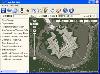 Arm Map Explorer recreates all the functionalities of Google Maps on your desktop while expanding them with new extras. Map Explorer lets you locate and view any place on the planet using dynamic interactive maps. These maps are draggable, which means there is no need for you to click and wait...
Platforms: Windows
| License: Freeware | Size: 5.46 MB | Download (197): Arm Map Explorer Download |
Added: February 03, 2010 | Visits: 1.855
Geo::ECEF is a Perl module that converts between ECEF (earth centered earth fixed) coordinates and latitude, longitude and height above ellipsoid. SYNOPSIS use Geo::ECEF; my $obj=Geo::ECEF->new(); #WGS84 is the default my ($x, $y, $z)=$obj->ecef(39.197807, -77.108574, 55); #Lat (deg), Lon...
Platforms: *nix
| License: Freeware | Size: 5.12 KB | Download (184): Geo::ECEF Download |
Added: October 25, 2010 | Visits: 969
Geo::Coordinates::VandH is a Perl module that can convert and manipulate telco V and H coordinates. SYNOPSIS To convert V: 5498 H: 2895 to lat/long coordinates: use Geo::Coordinates::VandH; $blah=new Geo::Coordinates::VandH; ($lat,$lon) = $blah->vh2ll(5498,2895); printf...
Platforms: *nix
| License: Freeware | Size: 4.1 KB | Download (115): Geo::Coordinates::VandH Download |
Added: July 12, 2010 | Visits: 1.302
Geo::Coordinates::OSGB is a Perl module that can convert coordinates from Lat/Long to UK Grid. A UK-specific implementation of co-ordinate conversion, following formulae from the Ordnance Survey of Great Britain (hence the name). SYNOPSIS use Geo::Coordinates::OSGB qw(ll2grid grid2ll); #...
Platforms: *nix
| License: Freeware | Size: 4.1 KB | Download (112): Geo::Coordinates::OSGB Download |
Added: May 15, 2010 | Visits: 769
Tk::Canvas Perl module can create and manipulate Canvas widgets. SYNOPSIS $canvas = $parent->Canvas(?options?); STANDARD OPTIONS -background -highlightthickness -insertwidth -state -borderwidth -insertbackground -relief -tile -cursor -insertborderwidth -selectbackground -takefocus...
Platforms: *nix
| License: Freeware | Size: 5.7 MB | Download (105): Tk::Canvas Download |
Added: August 03, 2008 | Visits: 906
Abykus is an object-oriented spreadsheet for Windows that adds an exciting new dimension to the classic 'what-if' analysis by allowing complex data types such as matrixes, coordinates, polygons, etc. to be stored in individual cells. Ideally suited for engineering, surveying and other scientific...
Platforms: Windows
| License: Freeware | Size: 573 KB | Download (104): Abykus Download |
Added: January 25, 2010 | Visits: 415
MouseStat is a menu bar status item that displays mouse location coordinates in the menu bar. (Corner origin is configurable.)
Platforms: Mac
| License: Freeware | Download (98): MouseStat Download |
Added: September 26, 2010 | Visits: 962
Bio::Location::CoordinatePolicyI is an abstract interface for objects implementing a certain policy of computing integer-valued coordinates of a Location. SYNOPSIS # get a location, e.g., from a SeqFeature $location = $feature->location(); # examine its coordinate computation policy print...
Platforms: *nix
| License: Freeware | Size: 4.7 MB | Download (90): Bio::Location::CoordinatePolicyI Download |
Added: July 02, 2013 | Visits: 439
"naca5gen.m" Generates the NACA 5 digit airfoil coordinates with desired no. of panels (line elements) on it. FEATURES: *Accurate coordinate generation with the required precision *Option to generate closed or open Trailing Edge *Additional separate outputs for camber line, upper surface and...
Platforms: Matlab
| License: Freeware | Size: 10 KB | Download (65): NACA 5 digit Airfoil Generator Download |
Added: September 06, 2013 | Visits: 459
"naca4gen.m" Generates the NACA 4 digit airfoil coordinates with desired no. of panels (line elements) on it.FEATURES: *Accurate coordinate generation with the required precision *Option to generate closed or open Trailing Edge *Additional separate outputs for camber line, upper surface and lower...
Platforms: Matlab
| License: Freeware | Size: 10 KB | Download (64): NACA 4 digit Airfoil Generator Download |