


Topo Maps software
Topo Maps
Released: July 07, 2004
|
Added: October 14, 2006 | Visits: 2.715
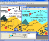 MagicMap is a software for extracting color layers from scanned images - topo maps and logos.
Platforms: Windows
| License: Demo | Cost: $95.00 USD | Size: 3.38 MB | Download (353): MagicMap Download |
Added: August 18, 2008 | Visits: 1.350
 Allows you to connect your hand held Global Positioning System (GPS) unit to your computer, download your waypoints, and plot them in AutoCAD or export them in .dxf Also plots the points on free public domain Aerial photos and topo maps. Works on most Garmin and Magellan GPS units, and AutoCAD...
Platforms: Windows
| License: Shareware | Cost: $345.00 USD | Size: 9.9 MB | Download (543): GPS2CAD Download |
Released: March 01, 2010
|
Added: April 22, 2010 | Visits: 2.515
 Mapyx Quo is an intuitive, easy to learn and, surprisingly simple-to-use digital mapping program which enables you to connect your GPS to your PC and manage all your waypoints, routes and tracks. View information such as elevation, distance, speed, ETA and many more. Quo supports numerous...
Platforms: Windows, Windows CE
| License: Freeware | Size: 44.95 MB | Download (7377): Mapyx Quo Download |
Released: July 01, 2012
|
Added: July 01, 2012 | Visits: 506
Topos US is an app that provides access to download and view high resolution USGS topographic maps for the United States.
REGARDING MAP DATES:
You will often see a date on a downloaded map that seems pretty old. This is the date of last physical survey. This could be a long time ago. Often...
Platforms: Mac
| License: Commercial | Cost: $2.99 USD | Size: 716.8 KB | Download (49): Topos US Download |
Added: January 25, 2010 | Visits: 854
GPSy is a sophisticated Macintosh GPS communications and GIS mapping program. GPSy connects your Macintosh to a broad range of Global Positioning System (GPS) navigational units and has advanced mapping, logging, and data transfer features. GPSy has extensive support for USGS DRG topo maps,...
Platforms: Mac
| License: Demo | Cost: $0.00 USD | Download (104): GPSy Download |
Released: August 23, 2012
|
Added: August 23, 2012 | Visits: 567
ExpertGPS is the ultimate mapping software for Garmin, Magellan, and Lowrance GPS owners. ExpertGPS displays your waypoints, routes, and tracks on USGS topo maps and aerial photos.
Using the powerful mapping tools in ExpertGPS, you can draw your route directly on a map, search for nearby...
Platforms: Windows
| License: Shareware | Cost: $74.95 USD | Size: 9.1 MB | Download (441): ExpertGPS Download |
Released: December 12, 2023
|
Added: December 23, 2023 | Visits: 1.236
 Universal Maps Downloader is a tool that help you to get small tile images from Google Maps, Openstreetmap, Yandex Maps, Yahoo Maps, Mapquest, Gaode map, Tencent Maps, Baidu Maps, Tianditu, Arcgis Online, OneMap, Whereis, mapy.cz, Mappy, Waze, Sentinel-2 map, Strava Gloabal Heatmap, Wikimapia,...
Platforms: Windows 8, Windows 7, Windows
| License: Shareware | Cost: $69.00 USD | Size: 30.7 MB | Download (147): Universal Maps Downloader |
Added: November 14, 2010 | Visits: 1.953
Crossfire Maps packages includes maps for the Crossfire MUD client. Crossfire is a multi-player graphical arcade and adventure game made for X. It has certain flavours from other games, especially Gauntlet and the rogue-like games (Nethack, Moria, Angband, and Ragnarok). Any number of players...
Platforms: *nix
| License: Freeware | Size: 21.2 MB | Download (165): Crossfire Maps Download |
Added: May 22, 2010 | Visits: 1.533
Maps project is a topographal map and aerial photo generator and viewer. Maps allows users to generate topographical maps and aerial photographs of any region in the United States. It uses data provided by the USGS through the geoserver system. The interactive view lets you move around,...
Platforms: *nix
| License: Freeware | Size: 11.26 KB | Download (139): Maps Download |
Released: January 12, 2012
|
Added: February 04, 2012 | Visits: 1.493
 Bubble maps software does scatter plot and circle charts in Excel, useful for advanced business analysis.
Excel provides the ability to draw bubble maps and scatter plots, but they are less refined than a bubble map you can make with the Smart Bubble Charts software. In Excel: (1) Chart...
Bubble maps software does scatter plot and circle charts in Excel, useful for advanced business analysis.
Excel provides the ability to draw bubble maps and scatter plots, but they are less refined than a bubble map you can make with the Smart Bubble Charts software. In Excel: (1) Chart...
Platforms: Windows
| License: Shareware | Cost: $54.65 USD | Size: 16.32 MB | Download (126): Bubble Maps Software Download |
Released: July 03, 2012
|
Added: July 03, 2012 | Visits: 602
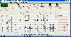
 A volume of data with map names, map numbers, corner coordinates and completing data of all official topographic maps of the Federal Republic of Germany. TK25: Data base table with data of the maps on a scale 1:25000. TK50: Table with data of the maps on a scale 1:50000. TK100: Table with data of...
Platforms: All
| License: Freeware | Size: 51.2 KB | Download (51): Geodaten German Topo Download |
Released: September 24, 2012
|
Added: September 24, 2012 | Visits: 918
This software development kit (SDK) provides the binaries and programming reference for the Bing Maps WPF Control (Beta).
When the installation completes, you can choose to open the Bing Maps WPF Control (Beta) SDK help file (BingMapsWPFControlSDK.chm).
Get Bing Maps WPF Control and give it a...
Platforms: Windows, XP, 2003, Windows Vista, 2008, 7
| License: Freeware | Download (52): Bing Maps WPF Control Download |
Released: June 13, 2012
|
Added: June 13, 2012 | Visits: 937
 Add realistic 3D capabilities to your online Bing Maps. Bing Maps 3D brings you another step closer to knowing "what it is like out there". You can search, browse, and organize local information viewed in three dimensions, just the way it exists in the real world. This enables you to more...
Platforms: Windows
| License: Freeware | Size: 1.2 MB | Download (511): Microsoft Bing Maps 3D Download |
Added: May 29, 2013 | Visits: 770
There are several plugins that can embed Google Maps into WordPress pages. However, most, if not all, of them require the user to specify the markup in a separate KML file. I found that troublesome, and hence created a plugin that allows the administrator to create a marker simply by clicking on...
Platforms: PHP
| License: Freeware | Size: 10 KB | Download (50): Organisation Maps Download |
Added: July 04, 2013 | Visits: 677
he "Yandex maps" module shows locative data using the Yandex maps API (http://api.yandex.ru/maps/).Yandex maps are the good Google Maps alternative for Russia and other eastern Europe countries.This module utilizes it's API and the main features are: * shows node locations in the blocks (using...
Platforms: PHP
| License: Freeware | Size: 20.48 KB | Download (43): Yandex maps Download |
Added: September 28, 2013 | Visits: 558
Get a Google Maps??a*zNz tooltip box attached to any address on any website or highlight text + use right-click menu to show it on a map immediately!
Platforms: Mac
| License: Shareware | Cost: $0.00 USD | Size: 51.2 KB | Download (39): Quick Maps Download |
Released: January 12, 2014
|
Added: September 18, 2014 | Visits: 783
 Maps Downloader For Google Map is a smart tool which can help you download tile satellite images from google map fastly and stably.It can stitch tile images into one big seamless image:Software can stitch tile images into one big seamless image such as GeoTIFF and GeoJPEG. But if the exported...
Platforms: Windows, Windows 7, Windows Server
| License: Shareware | Cost: $49.95 USD | Size: 4.71 MB | Download (1243): Maps Dwonloader For Google Map Download |
Released: July 23, 2014
|
Added: September 23, 2014 | Visits: 900
 Maps Downloader For Yahoo Map is a smart tool which can help you download tile satellite images from google map fastly and stably.It can stitch tile images into one big seamless image:Software can stitch tile images into one big seamless image such as GeoTIFF and GeoJPEG. But if the exported...
Platforms: Windows, Windows 7, Windows Server
| License: Shareware | Cost: $49.95 USD | Size: 4.84 MB | Download (1233): Maps Downloader For Yahoo Map |
Released: February 02, 2014
|
Added: September 23, 2014 | Visits: 1.104
 Maps Downloader For Bing Map is a smart tool which can help you download tile satellite images from google map fastly and stably.It can stitch tile images into one big seamless image:Software can stitch tile images into one big seamless image such as GeoTIFF and GeoJPEG. But if the exported...
Platforms: Windows, Windows 7, Windows Server
| License: Shareware | Cost: $49.95 USD | Size: 7.12 MB | Download (1231): Maps Downloader For Bing Map |
Released: January 13, 2014
|
Added: October 09, 2014 | Visits: 840
 Maps Downloader For Google Terrain is a smart tool which can help you download tile satellite images from google map fastly and stably.It can stitch tile images into one big seamless image:Software can stitch tile images into one big seamless image such as GeoTIFF and GeoJPEG. But if the...
Platforms: Windows, Windows 7, Windows Server
| License: Shareware | Cost: $49.95 USD | Size: 4.72 MB | Download (1234): Maps Downloader For Google Terrain |