


Nmea Gps Receivers software
Nmea Gps Receivers
Released: November 10, 2007
|
Added: November 20, 2007 | Visits: 6.089
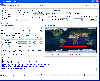
 Geocode digital images with latitude, longitude, altitude, and direction information. RoboGEO stamps this information onto the actual photo or writes it to the EXIF headers, allowing you to permanently geotag and link your photos to the GPS coordinates. All writing to the EXIF and IPTC headers...
Platforms: Windows
| License: Demo | Cost: $39.95 USD | Size: 8.28 MB | Download (1179): RoboGEO Download |
Added: January 25, 2010 | Visits: 874
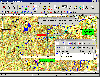
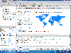
 Terrabrowser is an internet browser for satellite photos and topographical maps which are obtained from the Microsoft Terra Server. The map data is provided by the U.S. Geological Survey (USGS) and therefore only covers the United States at this time (although expansion to other map servers may...
Platforms: Mac
| License: Shareware | Cost: $0.00 USD | Download (98): Terrabrowser Download |
Added: January 25, 2010 | Visits: 784
LoadMyTracks is a utility that allows users of the Macintosh to download track, route, and waypoint information from a variety of GPS receivers from Garmin, Magellan, TomTom, Sony, Lowrance, Timex, and turn them into GPX files or KML files (for use with Google Earth). LoadMyTracks can also send...
Platforms: Mac
| License: Demo | Cost: $0.00 USD | Download (125): LoadMyTracks Download |
Released: June 09, 2012
|
Added: June 09, 2012 | Visits: 338
 OziExplorer is interactive, it allows you to work, on your computer screen, with digital maps that you have purchased or scanned yourself. By using these maps OziExplorer allows you to plan your trip by creating waypoints, routes and tracks on screen and upload these to your GPS.
With...
OziExplorer is interactive, it allows you to work, on your computer screen, with digital maps that you have purchased or scanned yourself. By using these maps OziExplorer allows you to plan your trip by creating waypoints, routes and tracks on screen and upload these to your GPS.
With...
Platforms: Windows
| License: Shareware | Cost: $95.00 USD | Size: 7 MB | Download (431): OziExplorer Download |
Released: September 09, 2012
|
Added: September 09, 2012 | Visits: 835
Communication with your Garmin GPS just got easier thanks to this Plugin - the free internet browser plugin that sends and retrieves data from Garmin GPS devices. The Garmin Communicator Plugin lets you connect your Garmin GPS with your favorite website. Once the plugin is installed, just connect...
Platforms: Mac
| License: Freeware | Size: 8.8 MB | Download (54): Garmin Communicator Plugin for Mac OS Download |
Released: November 26, 2012
|
Added: November 26, 2012 | Visits: 546
Let this software and a GPS logger do the hard work of assigning precise Places metadata to your photos. Why import ungeotagged pictures into iPhoto, when its so straightforward to GPS-enable your favorite camera?
Geotagalogs sophisticated automatic geotagging technology combines locations from...
Platforms: Mac
| License: Freeware | Size: 13.8 MB | Download (498): Geotagalog for Mac OS Download |
Released: September 27, 2012
|
Added: September 27, 2012 | Visits: 586
Garmin Communicator Plugin lets you connect your Garmin GPS with your favorite website. Once the plugin is installed, just connect your Garmin GPS device to your computer, and you're on your way. The Garmin Communicator can send and retrieve data from any supported website.
WHAT'S NEW
Version...
Platforms: Mac, Safari 2.0 or later or Firefox 2.0 or later
| License: Freeware | Size: 7.3 MB | Download (64): Garmin Communicator Plugin Download |
Released: December 30, 2019
|
Added: January 08, 2020 | Visits: 3.966
 SEVENPAR is a tool for the calculation of highly exact transformation parameters for the Spatial Helmert and Molodensky Transformation, which make possible precise coordinate transformations from one reference system into another. The determined transformation parameters can be entered directly...
Platforms: Windows, Windows 8, Windows 7, Windows Server
| License: Shareware | Cost: $145.00 USD | Size: 2.78 MB | Download (188): SEVENPAR Download |
Added: August 27, 2008 | Visits: 1.084
USAPhotoMaps downloads aerial photo and topo map data from Microsoft's free TerraServer Web site, saves it on your hard drive, and creates seamless maps from it. You can - Scroll and zoom, See the latitude/longitude, Add waypoints, routes, and text, Jump to any waypoint or latitude/longitude in...
Platforms: Windows
| License: Freeware | Size: 314 KB | Download (505): USAPhotoMaps Download |
Added: August 11, 2008 | Visits: 1.954
USA Photo Maps works to download aerial photos and topographical map data directly from the Microsoft TerraServer website, saving it to your hard drive and creating maps from there. With USA Photo Maps you can do the following:* Scroll and zoom operations.* See latitudes and longitudes.* See UGSS...
Platforms: Windows
| License: Freeware | Size: 5 KB | Download (524): USA Photo Maps Download |
Added: January 25, 2010 | Visits: 742
MacCaching is a Geocache Manager support Garmin and Magallen GPS receivers. Caches are managed in Lists which can be groups of caches in a certain area, caches you own, or caches you haven't found yet. An iPod or Palm-based device can be used for Paperless Caching when sending caches to your GPS....
Platforms: Mac
| License: Freeware | Download (98): MacCaching Download |
Released: March 02, 2014
|
Added: March 23, 2014 | Visits: 2.990
 HsTcp2Com is a communication application / Serial Device Server for Windows and Linux which allows forwarding / bridging data between serial ports (RS232 / RS485, bluetooth, IrDA, USB) represented as COM ports or /dev/tty serial devices and TCP/IP connections or UDP/IP links. In the simplest...
Platforms: Windows, Windows 7
| License: Shareware | Cost: $136.00 USD | Size: 759.68 KB | Download (162): HsTcp2Com Download |
Released: October 03, 2013
|
Added: May 14, 2014 | Visits: 549
 SEVENPAR is a tool for the calculation of highly exact transformation parameters for the Spatial Helmert and Molodensky Transformation, which make possible precise coordinate transformations from one reference system into another. The determined transformation parameters can be entered directly...
Platforms: Windows, Windows 7, Windows Server
| License: Shareware | Cost: $170.00 USD | Size: 1.66 MB | Download (38): SEVENPAR English Download |
Released: February 01, 2016
|
Added: February 13, 2016 | Visits: 474
 NMEA Converter is a product to convert various types of data
NMEA to UDP Converter
UDP to NMEA Converter(Reserved)
GPS to HDT Converter(Reserved)
NMEA to KML Converter(Reserved)
NMEA to KMZ Converter(Reserved)
KML to NMEA Converter(Reserved)
KMZ to NMEA Converter(Reserved)
NMEA Converter is a product to convert various types of data
NMEA to UDP Converter
UDP to NMEA Converter(Reserved)
GPS to HDT Converter(Reserved)
NMEA to KML Converter(Reserved)
NMEA to KMZ Converter(Reserved)
KML to NMEA Converter(Reserved)
KMZ to NMEA Converter(Reserved)
Platforms: Windows, Windows 8, Windows 7, Windows Server
| License: Demo | Cost: $29.00 USD | Size: 509 KB | Download (49): NMEA Converter Download |
Added: January 05, 2006 | Visits: 3.129
 NavTools GPS is a small and easy to use application to connect your PC or laptop to an existing GPS (NMEA 0183 serial connection) installation. Position cata will automatically be displayed and logged on your screen, and voyage data can be exchanged and shared with the NavTools Route voyage...
Platforms: Windows
| License: Shareware | Cost: $25.00 USD | Size: 1.5 MB | Download (254): NavTools GPS Download |
Added: February 04, 2006 | Visits: 4.830
 It is a PC Clock synchronization program. It is alternative solution to synchronizing with atomic clock using NTP(SNTP) and Internet. The program works in the interactive mode or in background. The program can be used as NMEA and COM port tester. It outputs a port receiving buffer, extracts all...
Platforms: Windows
| License: Shareware | Cost: $10.00 USD | Size: 446 KB | Download (288): GPS Time and Test Download |
Released: April 09, 2010
|
Added: July 05, 2010 | Visits: 3.474
 The Tro GPS Simulator provides a complete suite for all your GPS simulating needs and more. The Tro GPS Simulator uses the international standardized protocol NMEA-0183 for GPS data exchange. It can simulataneously send and recieve data.Furthermore it provides several input methods for GPS...
Platforms: Windows
| License: Demo | Cost: $99.00 USD | Size: 5.73 MB | Download (884): Tro GPS Simulator Download |
Released: February 09, 2014
|
Added: March 16, 2014 | Visits: 1.889
 The Vutog GPS Simulator provides a complete suite for all your GPS simulation needs and more. It is designed to assist in developing, testing and debugging GPS Applications and equipment working with the NMEA-0183 protocol. It can be used for testing navigation applications and equipments indoor...
Platforms: Windows, Windows 7
| License: Shareware | Cost: $149.00 USD | Size: 5.75 MB | Download (164): Vutog GPS Simulator Download |
Released: October 08, 2012
|
Added: October 08, 2012 | Visits: 575
 Virtual GPS is a GPS simulator software. You can use it to simulate a GPS receiver unit connected to your system. It's ideal when you need GPS input, but you have no signal or for development purposes. It supports various NMEA sentences, so it can be used with any GPS mapping software. You can...
Platforms: Windows, Other
| License: Shareware | Cost: $39.99 USD | Size: 946 KB | Download (74): Virtual GPS Download |
Added: August 19, 2013 | Visits: 492
Download NMEA Data From Garmin Etrex Vista GPS1-SELECT PORT.2-PUSH "START RECEIVING" BUTTON.3-SET DESTINATION FOR TXT FILE.4-AT THE END,PUSH "STOP RECEIVING".
Platforms: Matlab
| License: Shareware | Cost: $0.00 USD | Size: 20.48 KB | Download (40): Receive NMEA From Garmin Etrex vista GPS Download |