


Moving Map Picture software
Moving Map Picture
Released: September 21, 2012
|
Added: September 21, 2012 | Visits: 697
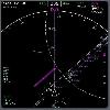
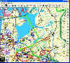 PocketFMS is the Moving Map and Flight Planning tool for PC, Tablet PC, UMPC, Pocket PC and Windows CE-based Car Navigation equipment. It comprises downloadable, worldwide maps, access to a comprehensive AeroDatabase, integrated & graphical weather with 48 hours prognosis, TCAS info and...
Platforms: Windows, Pocket PC
| License: Freeware | Size: 34.55 MB | Download (65): PocketFMS Download |
Added: August 22, 2013 | Visits: 270
 qpeGPS is a program for displaying a moving map centered at theposition read from a GPS device.It's designed to run on a PDA with Qt/embedded (qtopia).
Platforms: *nix
| License: Freeware | Size: 491.52 KB | Download (33): qpeGPS Download |
Released: October 10, 2012
|
Added: October 10, 2012 | Visits: 562
A software utility that listens on an IP network for UDP datagrams representing the geographical coordinates of the simulated flight path of an instance of the X-Plane® flight simulator, then transforms them into a series of continuously updated KML files that Google Earth® can ingest to create...
Platforms: Mac
| License: Freeware | Size: 768 KB | Download (46): Xplage for Mac OS Download |
Released: October 11, 2012
|
Added: October 11, 2012 | Visits: 402
EPS is a moving map project. If can use GPS units (currently GARMIN).
Platforms: Windows, Mac, Linux
| License: Freeware | Size: 1.26 MB | Download (44): EPS - The Elgaard Positioning System Download |
Released: June 23, 2012
|
Added: June 23, 2012 | Visits: 383
GPSylon is a Java moving map application that is able to display maps like in an atlas and show your position by the use of a gps device. It may track your path, load overlays (e.g. shape files), download maps from expedia servers.
Platforms: Windows, Mac, Linux
| License: Freeware | Size: 7.57 MB | Download (44): GPSylon Download |
Released: August 30, 2016
|
Added: October 02, 2016 | Visits: 739
 Have many holiday pictures and want to organize your photos? Yes, we offer you comprehensive picture manager of Google Photos using location.
MyFotoPlaces is built around Google Drive/Photos, so you can find and organize your images by the location.
While Google Drive provides excellent...
Have many holiday pictures and want to organize your photos? Yes, we offer you comprehensive picture manager of Google Photos using location.
MyFotoPlaces is built around Google Drive/Photos, so you can find and organize your images by the location.
While Google Drive provides excellent...
Platforms: Windows, Mac, *nix, DOS, Windows 7, Windows Server, Palm OS, Android, Pocket PC, Handheld, Other,BlackBerry,iPhone,iPod,iTouch,Palm,Not Applicable,Java,AS/400
| License: Freeware | Download (43): MyFotoPlaces Download |
Released: June 09, 2012
|
Added: June 09, 2012 | Visits: 338
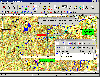 OziExplorer is interactive, it allows you to work, on your computer screen, with digital maps that you have purchased or scanned yourself. By using these maps OziExplorer allows you to plan your trip by creating waypoints, routes and tracks on screen and upload these to your GPS.
With...
OziExplorer is interactive, it allows you to work, on your computer screen, with digital maps that you have purchased or scanned yourself. By using these maps OziExplorer allows you to plan your trip by creating waypoints, routes and tracks on screen and upload these to your GPS.
With...
Platforms: Windows
| License: Shareware | Cost: $95.00 USD | Size: 7 MB | Download (431): OziExplorer Download |
Released: August 08, 2019
|
Added: September 09, 2019 | Visits: 2.901
 AnyMap JS Maps is an advanced JavaScript/HTML5 mapping library which makes you able to easily create interactive maps that look great on any device including PCs, Macs, iPhones, iPads, Android devices and others - on any platform and in any browser.
AnyMap JS is perfect for interactive...
AnyMap JS Maps is an advanced JavaScript/HTML5 mapping library which makes you able to easily create interactive maps that look great on any device including PCs, Macs, iPhones, iPads, Android devices and others - on any platform and in any browser.
AnyMap JS is perfect for interactive...
Platforms: Windows, Mac, *nix, Windows 8, Windows 7, Windows Server, iOS, Android, iPhone,iPad
| License: Shareware | Cost: $49.00 USD | Size: 17.81 MB | Download (1022): AnyMap JS Maps Download |
Added: January 25, 2010 | Visits: 574
CoolBackground allows you to use the screen saver selected in your preferences as a desktop picture. CoolBackground runs only on OS X 10.2 with Quartz Extreme. It is processor intensive, it is advised to use this application only with high-powered machines. Want to see CoolBackground in action?...
Platforms: Mac
| License: Freeware | Download (104): CoolBackground Download |
Added: August 21, 2013 | Visits: 530
autopilot is a command and control system for helicopters (and can be extended for fixed wing aircraft). It provides a three-axis EFIS and moving map on the ground station. The unmanned aerial robot has instrumentation for attitude, engine and position.
Platforms: *nix
| License: Freeware | Size: 737.28 KB | Download (35): autopilot: UAV command and control Download |
Added: August 31, 2008 | Visits: 3.344
GeoVisu is a visualization software for geographic data - graphic files, images and GPS. It provides real time GPS navigation (moving map - NMEA 0183 protocol or Garmin USB), displayed with diverse geographic data (MIF, GPX, NMEA, KML/KMZ, SHP, ECW, GeoTiff, MrSID). It can download waypoints,...
Platforms: Windows
| License: Freeware | Size: 1.5 MB | Download (1383): GeoVisu Download |
Added: January 25, 2010 | Visits: 691
HourWorld Live Deskpicture places a dynmaic image of the earth rotating as the day goes by. You can pick high-resolution maps that take more power to run but they look spectacular.
Platforms: Mac
| License: Shareware | Cost: $0.00 USD | Size: 1.1 MB | Download (105): HourWorld Live Deskpicture Download |
Released: October 23, 2012
|
Added: October 23, 2012 | Visits: 651
GPS Utility is an easy-to-use application that provides management and manipulation of GPS information. You can use it to transfer data to/from a GPS receiver and store the data in PC files in one of several text formats.
The program converts between different map datums and many coordinate...
Platforms: Windows
| License: Freeware | Size: 1.87 MB | Download (469): GPS Utility Download |
Released: August 20, 2012
|
Added: August 20, 2012 | Visits: 392
OpenEFB was specially developed as an Electronic FlightBag application for virtual pilots that use FSX, FS2004 or X-Plane.
The utility is meant to be used as a device for displaying charts, manuals and as a moving map, like an EFB in the real environment.
Platforms: Windows, Windows Vista, 7
| License: Freeware | Download (441): OpenEFB Download |
Released: October 23, 2012
|
Added: October 23, 2012 | Visits: 566
 Use GPS without GPS receiver! Try this advanced GPS device simulator (virtual GPS receiver). It can be used for development purposes or for testing GPS software before buying. Generates NMEA messages from different data inputs (map or file). Generated NMEA data can be used by mapping or other GPS...
Platforms: Windows
| License: Shareware | Cost: $39.99 USD | Size: 800 KB | Download (534): Avangardo GPS generator PRO Download |
Released: December 05, 2012
|
Added: December 05, 2012 | Visits: 415
Galaxy Transport is a Galaxy / Galaxy NG / Galaxy PLUS viewer.GTR should provide game map picture, battle animation and someautomatization of game process.Uses QT/SDL/Win32 libraries (configurable on compilation stage).
Platforms: Windows, Mac, Linux
| License: Freeware | Size: 99.33 KB | Download (50): Galaxy Transport Download |
Released: July 13, 2012
|
Added: July 13, 2012 | Visits: 217
 This software allows FlightGear (http://www.flighgear.org ) users to display their plane position and other navigational data on a moving map from the openstreetmap ( http://www.openstreetmap.org ) project.
Platforms: Windows, Mac, Linux
| License: Freeware | Size: 1.38 MB | Download (43): jMapView Download |
Released: October 14, 2012
|
Added: October 14, 2012 | Visits: 545
 XHSI is an add-on for the X-Plane flight simulator. It simulates a Navigation Display (Horizontal Situation Indicator with moving map) styled after the Boeing 737-NG series, but can be used with any X-Plane aircraft.
Platforms: Windows, Mac, Linux
| License: Freeware | Size: 1.02 MB | Download (49): XHSI - Navigation Display for X-Plane Download |
Released: September 07, 2002
|
Added: June 13, 2006 | Visits: 3.571
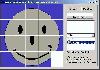 Picture Puzzle 1.2 This is Just a basic Game where you have to move around the pieces of the puzzle and try to put them in order. The games is simple free an fun. Try it out. You change the picture to another bit map .bmp
Platforms: Windows
| License: Freeware | Size: 1.55 MB | Download (177): !Picture Puzzle Wizard Download |
Released: November 20, 2012
|
Added: November 20, 2012 | Visits: 614
 "Peter's Moving Jigsaws" have received a tremendous reception - they have all the features of "Peter's Jigsaws" and yet the whole picture moves all the time that you are solving the puzzle - even the preview picture moves. If you've never tried a moving jigsaw before then you're in for a real...
Platforms: Windows
| License: Shareware | Cost: $21.00 USD | Download (510): Peter's Moving Jigsaws Download |