


Latitude Longitude Maps software
Latitude Longitude Maps
Released: October 16, 2012
|
Added: October 16, 2012 | Visits: 1.010
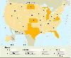 USA Real Estate Map Pro is a premium class software for mapping: real estate properties, contact listings, offices and other geo spatial data. Interactive Real Estate map is rather simple to integrate with database listings: both to specify the states and counties that should be active on map,...
Platforms: Windows, Mac, OS/2, Unix, Linux, MS-DOS, AS/400
| License: Shareware | Cost: $399.00 USD | Size: 10.42 MB | Download (520): USA Real Estate Map Pro Download |
Added: May 10, 2013 | Visits: 290
 These tracks are intended to be visualised on maps, plotted as distance/altitude profiles, have statistics derived from them, etc.The 'base' trackfield CCK field knows about latitude, longitude, altitude and distance.Due to the flexibility of the system, the distance/altitude pairs can be...
Platforms: Windows, Mac, *nix, PHP, BSD Solaris
| License: Freeware | Download (54): Trackfield 5.x-0.5 Download |
Added: May 10, 2013 | Visits: 617
This radius search tool is based on Yahoo! Maps Flash API and provides a map UI with the capability to connect to a web service, submit a center Latitude/Longitude point and a radius, and plot the returned data on the map.
Platforms: Windows, Mac, *nix, Flash, BSD Solaris
| License: Freeware | Download (57): RadiusSearchTool 0.1a Download |
Added: July 03, 2013 | Visits: 366
GeoPress adds geographic tagging of your posts and pages. You can enter an address, points on a map, or enter latitude & longitude using the post interface. You can also include the post location within the body itself to make it easy to geotag using emailed posts and desktop clients. Maps can be...
Platforms: PHP
| License: Freeware | Size: 10 KB | Download (50): GeoPress Download |
Added: May 05, 2013 | Visits: 400
This is a simple module to let users store their location on the edit account page. It uses HTML5d-deOaos geolocation API and stores latitude and longitude. How you use that data is up to other modules.
Platforms: PHP
| License: Freeware | Size: 20.48 KB | Download (46): HTML5 user geolocation Download |
Added: May 23, 2013 | Visits: 435
This module is a very basic WMS client which doesn't directly support tile based maps. Most online mapping sites are better served by the OpenLayers module which does.Nice Map is a WMS client for Drupal. It comes with views module support and should work with latitude/longitude data stored by...
Platforms: PHP
| License: Freeware | Size: 20.48 KB | Download (45): Nice Map Download |
Added: August 30, 2013 | Visits: 415
Gmap_geo provides a Google Map location picker widget for Geo point fields and a Google Maps-based output formatter for point, line, and polygon fields.HOWEVER: Gmap_geo was written for an earlier iteration of the Geo module. It has not been updated to use recent Geo API changes. If you are...
Platforms: PHP
| License: Freeware | Size: 10 KB | Download (43): GMap + Geo Download |
Added: July 07, 2013 | Visits: 318
This module will geocode just about anything you throw at it or hook up to it including addresses, GPX files, geo-tagged images, and KML files.It is commonly used to automatically geocode Addressfield addresses into Geofield points for display on Openlayers Maps.This module also makes available...
Platforms: PHP
| License: Shareware | Cost: $0.00 USD | Size: 10 KB | Download (39): Geocoder (Sripts) Download |
Released: March 15, 2008
|
Added: April 30, 2008 | Visits: 4.638
 With MobiumGPS , your Windows Mobile device is turned into an advanced Mobile Navigation System with turn-by-turn voice announcements and detailed driving directions. You can search over 15 million point of interests (POIs) - places like hotels, restaurants, shopping malls and other tourist...
Platforms: Windows
| License: Demo | Cost: $9.95 USD | Size: 806.13 KB | Download (1554): Mobium GPS Navigation System Download |
Added: August 17, 2008 | Visits: 997
IPSearchLight is a software component used to identify the geographic location of website visitors, often within a few miles from the exact location. The process utilizes each visitor's IP address; this technique is silent and unintrusive. IPSearchLight is ideal for practical applications like...
Platforms: Windows
| License: Freeware | Size: 8.74 KB | Download (447): IPSearchLight GeoLocator for ASP.NET 2.0 Download |
Released: October 22, 2012
|
Added: October 22, 2012 | Visits: 465
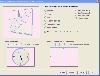 Shadows is a program used to design sundials and astrolabes. It can be used by everybody without any required technical skills. Shadows will calculate everything and print the drawing according the user's preferences. Shadows is used by thousands of users around the world.
Shadows offers a...
Shadows is a program used to design sundials and astrolabes. It can be used by everybody without any required technical skills. Shadows will calculate everything and print the drawing according the user's preferences. Shadows is used by thousands of users around the world.
Shadows offers a...
Platforms: Windows
| License: Freeware | Size: 7.5 MB | Download (457): Shadows Download |
Released: November 09, 2012
|
Added: November 09, 2012 | Visits: 485
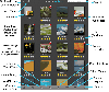 Arrange photos in folders and sub-folders or use filters (keywords, ratings, favorites) to find your photos. Geocoding data displays where an image was taken on Google maps. Plus, this .app allows you to view a photos metadata and arrange the order of your photos (manual, rating, date, file size)...
Platforms: iOS
| License: Shareware | Cost: $2.99 USD | Size: 7.1 MB | Download (478): Photo Folder Download |
Released: September 01, 2012
|
Added: September 01, 2012 | Visits: 945
A free 802.11 wireless scanner and connection manager for Mac OS X 10.6 Snow Leopard or later. This will detect access points and clients in ad-hoc mode if the SSID is being broadcasted. It can be used for wireless site surveys, wireless discovery, and to connect to wifi networks. The tool...
Platforms: Mac
| License: Freeware | Size: 768 KB | Download (428): WiFi Scanner for Mac OS Download |
Released: September 20, 2012
|
Added: September 20, 2012 | Visits: 949
 A professional-quality interactive world map that can be customized for your unique needs. This is the ideal solution for displaying global offices, travel information, dealer locations, or just visualizing country statistics. You can easily customize almost every aspect of the map and we've...
Platforms: Not Applicable
| License: Freeware | Size: 864 KB | Download (72): Interactive Flash World Map Download |
Added: June 25, 2013 | Visits: 284
If carefully built, a sundial is perfectly capable of keeping accurate time. The problem is that you need a different sundial for every combination of latitude, longitude, and day of the year. Fortunately MATLABdlT« can make this a manageable problem. By turning this procedure around, you can...
Platforms: Matlab
| License: Shareware | Cost: $0.00 USD | Size: 20.48 KB | Download (39): Building Sundials Download |
Added: June 27, 2013 | Visits: 501
This module delivers support for the Mapstraction javascript library, which provides an abstraction layer for the various map providers including Google, Yahoo!, and MapQuest. It allows you to quickly display maps on your site from multiple providers and switch between providers without worrying...
Platforms: PHP
| License: Freeware | Size: 10 KB | Download (52): Mapstraction Download |
Added: August 03, 2013 | Visits: 317
This plugin allows you to add a Geoportail map into your post/page using shortcodes. To use it, you need a free key from : http://api.ign.fr/geoportail New : You can now set your API Key directly on the option menu.Any question, idea or comment ? Please contact me at :...
Platforms: PHP
| License: Shareware | Cost: $0.00 USD | Size: 10 KB | Download (44): Geoportail Shortcode Download |
Added: November 01, 2013 | Visits: 447
Java OceanAtlas (or simply JOA) is a software application for viewing and manipulating oceanographic profile data. JOA was designed primarily for oceanographic sections but is also useful for looking at data also in the latitude-longitude domain. Here's a brief list of what JOA can do: * Open a...
Platforms: Mac
| License: Freeware | Size: 14.1 MB | Download (40): Java OceanAtlas Download |
Added: October 10, 2013 | Visits: 563
Landscape photographers typically wish to plan their shoots around the times of sunset/sunrise or twilight, or alternatively when the moon is in a particular place in a particular phase. While times of sunrise etc. are readily available on various sites on the internet (direction of sunrise etc....
Platforms: Mac
| License: Freeware | Size: 2.25 MB | Download (52): The Photographer's Ephemeris Download |
Released: November 07, 2014
|
Added: November 19, 2014 | Visits: 814
 Importation/Exportation: Import/export trails to gpx file. Unlimited number of trails, and TrackPoints. Export to gpx, Excel, PDF, XPS and KML/KMZ.
Data table: Very flexible data table that allows sorting by columns, with inheritance of data, attributes, etc.
Presentation on map: View...
Importation/Exportation: Import/export trails to gpx file. Unlimited number of trails, and TrackPoints. Export to gpx, Excel, PDF, XPS and KML/KMZ.
Data table: Very flexible data table that allows sorting by columns, with inheritance of data, attributes, etc.
Presentation on map: View...
Platforms: Windows, Windows 8, Windows 7, Windows Server
| License: Freeware | Size: 27.05 MB | Download (611): ediTrail Download |