


Gpx software
Gpx
Released: March 01, 2010
|
Added: April 22, 2010 | Visits: 2.515
 Mapyx Quo is an intuitive, easy to learn and, surprisingly simple-to-use digital mapping program which enables you to connect your GPS to your PC and manage all your waypoints, routes and tracks. View information such as elevation, distance, speed, ETA and many more. Quo supports numerous...
Platforms: Windows, Windows CE
| License: Freeware | Size: 44.95 MB | Download (7377): Mapyx Quo Download |
Released: April 22, 2008
|
Added: April 26, 2008 | Visits: 9.510
 The free AvisMap Viewer opens most GIS/CAD and raster image file types and most ArcView, ArcExplorer, and MapInfo projects. Besides just opening and viewing files, the Viewer supports an extensive list of features including visual layer properties control, legend control, thematic mapping,...
Platforms: Windows
| License: Freeware | Size: 22.28 MB | Download (1734): AvisMap Free Viewer Download |
Added: August 31, 2008 | Visits: 3.343
GeoVisu is a visualization software for geographic data - graphic files, images and GPS. It provides real time GPS navigation (moving map - NMEA 0183 protocol or Garmin USB), displayed with diverse geographic data (MIF, GPX, NMEA, KML/KMZ, SHP, ECW, GeoTiff, MrSID). It can download waypoints,...
Platforms: Windows
| License: Freeware | Size: 1.5 MB | Download (1383): GeoVisu Download |
Released: September 08, 2009
|
Added: September 14, 2009 | Visits: 3.869
 PhotoGPSEditor is an easy to use meta-data editor for photo (JPEG, RAW) files, plus it can match data from GPS (gpx or NMEA) files. The program is freeware, however, donations can be made to help support future development. With PhotoGPSEditor you can add location and summary details to a...
Platforms: Mac
| License: Freeware | Size: 2.39 MB | Download (1330): PhotoGPSEditor Download |
Released: December 29, 2010
|
Added: January 06, 2011 | Visits: 4.315
 OkMap is a GPS and map software that:
-Works with vectorial maps and calibrates raster maps
-Organizes paths by creating waypoints, routes and tracks
-Uploads/downloads data to/from your GPS
-Uses altitude DEM data
-Supports GPS real-time navigation
-Sends/receives vehicles position...
OkMap is a GPS and map software that:
-Works with vectorial maps and calibrates raster maps
-Organizes paths by creating waypoints, routes and tracks
-Uploads/downloads data to/from your GPS
-Uses altitude DEM data
-Supports GPS real-time navigation
-Sends/receives vehicles position...
Platforms: Windows
| License: Freeware | Size: 20.25 MB | Download (1277): OkMap Download |
Released: November 10, 2007
|
Added: November 20, 2007 | Visits: 6.089
 Geocode digital images with latitude, longitude, altitude, and direction information. RoboGEO stamps this information onto the actual photo or writes it to the EXIF headers, allowing you to permanently geotag and link your photos to the GPS coordinates. All writing to the EXIF and IPTC headers...
Platforms: Windows
| License: Demo | Cost: $39.95 USD | Size: 8.28 MB | Download (1179): RoboGEO Download |
Released: January 25, 2010
|
Added: August 18, 2010 | Visits: 1.059
 Set of programs to convert GPS-tracks of *.gpx, *.mps, *.plt or *.nmea format to route files *.rt2. Software creates two route files - forward route and backward one.
Platforms: Windows
| License: Freeware | Size: 26.06 KB | Download (878): Gpx2rt2 Download |
Released: May 25, 2018
|
Added: June 25, 2018 | Visits: 3.605
 HoudahGeo is a photo geocoding and geotagging tool for Mac. Use HoudahGeo to attach GPS coordinates and location names to your photos.
HoudahGeo writes EXIF and XMP geotags to JPEG and RAW image files. This creates a permanent record of where a photo was taken. Just like a GPS-enabled camera....
HoudahGeo is a photo geocoding and geotagging tool for Mac. Use HoudahGeo to attach GPS coordinates and location names to your photos.
HoudahGeo writes EXIF and XMP geotags to JPEG and RAW image files. This creates a permanent record of where a photo was taken. Just like a GPS-enabled camera....
Platforms: Mac
| License: Demo | Cost: $39.00 USD | Size: 22.87 MB | Download (837): HoudahGeo Download |
Released: March 29, 2024
|
Added: April 20, 2024 | Visits: 268
AnyGo offers you 5 modes namely Teleport Mode, Two-Spot Route, Multi-Spot Route, Joystick Mode, and importing GPX routes to change your location or simulate the movement of your GPS easily. You can connect different iOS/Android devices to the same computer for GPS location spoofing or movement...
Platforms: Windows, Windows 8, Windows 7, Windows Server
| License: Free Trial | Cost: $9.95 USD | Size: 136.13 MB | Download (633): AnyGo Download |
Released: January 20, 2012
|
Added: March 05, 2013 | Visits: 846
 A program to convert GPS-track of *.gpx, *.mps, *.plt or *.nmea format to Navitel Tracks.bin "blue line" file.
Platforms: Windows
| License: Freeware | Size: 31.64 KB | Download (623): Gpx2bin Download |
Released: November 07, 2014
|
Added: November 19, 2014 | Visits: 813
 Importation/Exportation: Import/export trails to gpx file. Unlimited number of trails, and TrackPoints. Export to gpx, Excel, PDF, XPS and KML/KMZ.
Data table: Very flexible data table that allows sorting by columns, with inheritance of data, attributes, etc.
Presentation on map: View...
Importation/Exportation: Import/export trails to gpx file. Unlimited number of trails, and TrackPoints. Export to gpx, Excel, PDF, XPS and KML/KMZ.
Data table: Very flexible data table that allows sorting by columns, with inheritance of data, attributes, etc.
Presentation on map: View...
Platforms: Windows, Windows 8, Windows 7, Windows Server
| License: Freeware | Size: 27.05 MB | Download (611): ediTrail Download |
Released: December 22, 2012
|
Added: December 22, 2012 | Visits: 468
 Run.GPS Trainer UV is the perfect tool to take along doing all sorts of sports like running, skiing, hiking, and many more. Run.GPS Trainer UV is compatible with most PocketPCs and Smartphones (requires Windows Mobile 2003 Pocket PC, Windows Mobile 5 or Windows Mobile 6). Recording *...
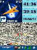
Platforms: Windows, Pocket PC
| License: Shareware | Cost: $33.99 USD | Size: 6.29 MB | Download (600): Run.GPS Trainer UV Download |
Released: December 26, 2012
|
Added: December 26, 2012 | Visits: 703
If you've ever thought about becoming a GeoCacher, then you know that the only way to get GPX files from GeoCaching. com is to pay for their membership services. That means a regular monthly charge to your credit card. But your PocketPC or GPS unit requires this type of file. This isn't a problem...
Platforms: Linux
| License: Commercial | Cost: $9.99 USD | Size: 4 KB | Download (512): GeoCache GPX Grabber Download |
Released: July 04, 2012
|
Added: July 04, 2012 | Visits: 388
 GUI for convert Navi Gpx Files to HTML, XML or CSV include Java API
Platforms: Windows, Mac, Java, Linux, Linux Console, Linux Gnome, Linux GPL, Linux Open Source, Unix, Other
| License: Freeware | Size: 1.77 MB | Download (510): TWGpx Download |
Released: June 13, 2012
|
Added: June 13, 2012 | Visits: 445
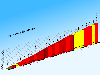 CycloGraph is a handy program to help you plot the gradient of roads using distances and heights. An Open Source alternative to Salitaker for plotting the profile of the roads you are planning to do with your bicycle. It also can import routes from kml. FEATURES: · import kml files · open...
Platforms: Windows
| License: Freeware | Size: 16.2 MB | Download (504): CycloGraph Download |
Released: November 26, 2012
|
Added: November 26, 2012 | Visits: 546
Let this software and a GPS logger do the hard work of assigning precise Places metadata to your photos. Why import ungeotagged pictures into iPhoto, when its so straightforward to GPS-enable your favorite camera?
Geotagalogs sophisticated automatic geotagging technology combines locations from...
Platforms: Mac
| License: Freeware | Size: 13.8 MB | Download (498): Geotagalog for Mac OS Download |
Released: October 22, 2012
|
Added: October 22, 2012 | Visits: 419
An intuitive geocache management and planning tool. Manage all your Geocaches from one place. Send only the caches you want to your GPS receiver. When you're done Geocaching, download them to Geocache Manager to automatically update your finds. Import Geocaches from queries, .loc or .gpx files....
Platforms: Mac
| License: Freeware | Size: 5 MB | Download (497): Geocache Manager for Mac OS Download |
Released: October 11, 2012
|
Added: October 11, 2012 | Visits: 538
A utility for uploading, downloading, and transcoding GPS data among GPS devices, GPX files, and KML files (for Google Earth). The resulting files can be used in a variety of applications available for the Macintosh, including TrackRunner, TrailRunner, and of course Google Earth.
Use...
Platforms: Mac
| License: Freeware | Size: 1.8 MB | Download (483): LoadMyTracks for Mac OS Download |
Released: August 23, 2012
|
Added: August 23, 2012 | Visits: 665
 All-in-one software for creation of custom GPS maps compatible with Garmin GPS units. Mapwel supports routing, ESRI shapefiles, OpenStreetMap OSM, Google Earth KML and KMZ, cGPSmapper MP and GPX files. Mapwel custom GPS mapping capability and user icons editor are often used in forestry,...
Platforms: Windows
| License: Shareware | Cost: $45.00 USD | Size: 12.28 MB | Download (454): Mapwel Download |
Released: June 25, 2012
|
Added: June 25, 2012 | Visits: 868
 The free AvisMap Viewer opens most GIS/CAD and raster image file types and most ArcView, ArcExplorer, and MapInfo projects. Besides just opening and viewing files, the Viewer supports an extensive list of features including visual layer properties control, legend control, thematic mapping,...
Platforms: Windows
| License: Freeware | Size: 23.17 MB | Download (449): Free Shapefile Viewer Download |