


Geographic Distances software
Geographic Distances
Added: July 24, 2006 | Visits: 5.477
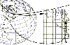
 Using Gates wrought of arcane magic, we crossed unimaginable distances to settle hundreds of worlds. Now the earth is almost conquest, safe it commander
Platforms: Windows
| License: Freeware | Size: 95.05 MB | Download (2054): Arcane Gate Download |
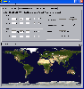
Added: August 31, 2008 | Visits: 3.343
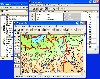
 GeoVisu is a visualization software for geographic data - graphic files, images and GPS. It provides real time GPS navigation (moving map - NMEA 0183 protocol or Garmin USB), displayed with diverse geographic data (MIF, GPX, NMEA, KML/KMZ, SHP, ECW, GeoTiff, MrSID). It can download waypoints,...
Platforms: Windows
| License: Freeware | Size: 1.5 MB | Download (1383): GeoVisu Download |
Released: January 02, 2007
|
Added: January 06, 2007 | Visits: 2.635
 Imports gridded data into Microsoft MapPoint, to produce attractive data maps that resemble contour maps.
Input data consists of a value that is defined for various (gridded) geographic coordinates. Common text output formats such as CSV are supported.
Can handle imperfect data, holes,...
Imports gridded data into Microsoft MapPoint, to produce attractive data maps that resemble contour maps.
Input data consists of a value that is defined for various (gridded) geographic coordinates. Common text output formats such as CSV are supported.
Can handle imperfect data, holes,...
Platforms: Windows
| License: Shareware | Cost: $75.00 USD | Size: 2.16 MB | Download (899): GridImp Download |
Added: November 04, 2006 | Visits: 5.961
 WhereIsIP is an interesting and powerful Internet tool to help you know the geographic location of an internet user who you are interested with . You can use it to find where a member of chatroom or email sender even ICQ friend TRULY come from , or where the website you visited is .
Simplily...
WhereIsIP is an interesting and powerful Internet tool to help you know the geographic location of an internet user who you are interested with . You can use it to find where a member of chatroom or email sender even ICQ friend TRULY come from , or where the website you visited is .
Simplily...
| License: Shareware | Cost: $19.50 USD | Size: 548 KB | Download (750): WhereIsIP Download |
Added: August 14, 2008 | Visits: 1.750
 CoordTrans converts geographic positions between different coordinate systems.Convert between UTM and WGS84.Convert between UTM and NAD27 / NAD83.And more... grids from 17 countries supported. Convert geographic coordinates (latitude / longitude) between different datums.
Platforms: Windows
| License: Shareware | Cost: $19.95 USD | Size: 669 KB | Download (744): CoordTrans Download |
Added: August 23, 2008 | Visits: 2.615
Mileage chart for 69 major US cities for quickly calculating distances. Mileages were gathered from several sources and averaged so distances are accurate to probably about 20-30 miles.
Platforms: Windows
| License: Freeware | Size: 44 KB | Download (626): Mileage Chart Download |
Released: January 16, 2013
|
Added: February 14, 2013 | Visits: 2.261
 Travel across Europe as king of the road, a trucker who delivers important cargo across impressive distances! With dozens of cities to explore from the UK, Belgium, Italy, the Netherlands, Poland, and many more, your endurance, skill and speed will all be pushed to their limits. If you've got...
Platforms: Windows
| License: Demo | Cost: $39.95 USD | Size: 541.61 MB | Download (553): Euro Truck Simulator 2 Download |
Added: August 04, 2008 | Visits: 1.164
 GIS ObjectLand is a universal Geographic Information System for Windows. Key capabilities: vector-raster maps; multiuser data editing; import and export for MIF/MID (MapInfo), SHP (ArcView), DXF (AutoCAD), DBF (dBASE), CSV; setting access permissions to data for different categories of users;...
Platforms: Windows
| License: Shareware | Cost: $99.00 USD | Size: 23.54 MB | Download (537): GIS ObjectLand Download |
Added: August 30, 2008 | Visits: 1.464
 GPS client library component for Visual Basic to read and decode standard GPS NMEA 183 sentences from the RS232 serial port as well as compute great circle distances and bearings, from within an application. Includes several VB (and VB.NET) example programs with full source code. Fully functional...
Platforms: Windows
| License: Shareware | Cost: $105.00 USD | Size: 296 KB | Download (528): MarshallSoft GPS Component for Visual Basic Download |
Released: November 03, 2012
|
Added: November 03, 2012 | Visits: 991
Explore rainforest scenes and find clues to follow the trail of a missing National Geographic researcher, and discover the Lost City of the Amazon. Using the tools and clues you find along the way, trace the paths of explorers who searched for an ancient civilization. Decipher mysterious messages...
Platforms: Mac
| License: Freeware | Size: 124 MB | Download (506): Lost City of Z for Mac OS Download |
Released: June 13, 2012
|
Added: June 13, 2012 | Visits: 444
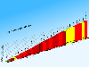 CycloGraph is a handy program to help you plot the gradient of roads using distances and heights. An Open Source alternative to Salitaker for plotting the profile of the roads you are planning to do with your bicycle. It also can import routes from kml. FEATURES: · import kml files · open...
Platforms: Windows
| License: Freeware | Size: 16.2 MB | Download (504): CycloGraph Download |
Released: November 05, 2012
|
Added: November 05, 2012 | Visits: 675
Bring National Geographic to life in Lilly Wu and the Terra Cotta Mystery, and lead a forensic expedition to settle a 2,000 year-old mystery. Emperor Qin was the first Emperor of China who died under mysterious circumstances. Was it an accident, or an assassination? Two thousand years later, the...
Platforms: Mac
| License: Freeware | Size: 192 MB | Download (502): Lilly Wu & the Terra Cotta Mystery for Mac OS Download |
Added: August 23, 2008 | Visits: 968
 GPS client library component reads and decodes standard GPS NMEA 183 sentences from the RS232 serial port as well as compute great circle distances and bearings. Several C/C++ example programs with full source code are included.Requires Windows C/C++ compiler.Registration is $105 for email delivery.
Platforms: Windows
| License: Shareware | Cost: $105.00 USD | Size: 327 KB | Download (480): MarshallSoft GPS Component for C C++ Download |
Released: September 25, 2012
|
Added: September 25, 2012 | Visits: 682
 As an elite volunteer for National Geographic’s Eco Rescue team, visit over 20 river sites across the world as you save species large and small by cleaning up the environment. Start with the prototype CleanClaw, a 1 man eco-friendly crane, and upgrade your equipment as you master currents and...
Platforms: Windows
| License: Freeware | Size: 65.03 MB | Download (474): Eco Rescue Rivers Download |
Released: August 15, 2012
|
Added: August 15, 2012 | Visits: 696
Gives players the opportunity to plan a green city. As mayor of your hometown, with the promise of changing the old ways of the past, to bring about a new green future. You are working with close supporters to restore this town to former glory and beauty. Watch as Greenville transforms before...
Platforms: Mac
| License: Freeware | Size: 78 MB | Download (464): National Geographic: Plan It Green for Mac OS Download |
Released: October 21, 2012
|
Added: October 21, 2012 | Visits: 739
Thuban is an interactive geographic data viewer (GIS viewer) which features methods to visualize, explore, and analyze geographic information.
Thuban is an Interactive Geographic Data Viewer with the following features:
# Vector Data Support: Shapefile, PostGIS Layer and OGR
# Raster Data...
Platforms: Linux
| License: Freeware | Size: 1.18 MB | Download (458): Thuban for Linux Download |
Released: October 27, 2012
|
Added: October 27, 2012 | Visits: 322
A tool for measuring distances and angles on the screen. Excellent for designers or anyone who wants to measure a distance on their screen in any window or application!. Most of what PixelStick does is obvious. Drag the endpoints to change the measurement. Click the locks to constrain the...
Platforms: Mac
| License: Freeware | Size: 624.64 KB | Download (457): PixelStick for Mac OS Download |
Released: October 08, 2012
|
Added: October 08, 2012 | Visits: 518
 GreatCirc is a tool for calculating Great Circle distances on the earth's surface, and plotting points and great circle paths on a world map.
The "great circle path" is the shortest direct route between two points on the earth's surface. Because the earth is a globe, the shortest path between...
GreatCirc is a tool for calculating Great Circle distances on the earth's surface, and plotting points and great circle paths on a world map.
The "great circle path" is the shortest direct route between two points on the earth's surface. Because the earth is a globe, the shortest path between...
Platforms: Windows
| License: Freeware | Size: 2.2 MB | Download (455): GreatCirc Download |
Released: September 20, 2012
|
Added: September 20, 2012 | Visits: 544
 ZoomMagic is a powerful tool to magnify any portion of your screen, measure distances or capture a screen area. Targeted users are: designers and developers on the hunt for those lost pixels .. or in the need for a fast screencapture, users with visual impairments or anybody who needs to find the...
Platforms: Windows
| License: Freeware | Size: 2.03 MB | Download (449): ZoomMagic Download |
Added: August 17, 2008 | Visits: 997
IPSearchLight is a software component used to identify the geographic location of website visitors, often within a few miles from the exact location. The process utilizes each visitor's IP address; this technique is silent and unintrusive. IPSearchLight is ideal for practical applications like...
Platforms: Windows
| License: Freeware | Size: 8.74 KB | Download (447): IPSearchLight GeoLocator for ASP.NET 2.0 Download |