


Geo Vision software
Geo Vision
Released: September 10, 2005
|
Added: September 03, 2006 | Visits: 3.734
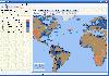 Now you can trace your network activity on world map.
GEO Spider helps you to trace, identify and monitor your network activity on world map. You can trace any website or IP address on your map.
Built on .NET technology GEO Spider uses fast and reliable approach in detecting hostnames, IP...
Now you can trace your network activity on world map.
GEO Spider helps you to trace, identify and monitor your network activity on world map. You can trace any website or IP address on your map.
Built on .NET technology GEO Spider uses fast and reliable approach in detecting hostnames, IP...
Platforms: Windows
| License: Shareware | Cost: $20.00 USD | Size: 10.26 MB | Download (287): GEO Spider Download |
Released: November 09, 2006
|
Added: November 14, 2006 | Visits: 4.287
 Geo World is a handy application for finding out detailed information about any country in the world. One of its advantages is that you can find the country you were looking for by Internet Country Code, Capital and etc. Also it's supplied with more than 530 images which represent flags and maps...
Platforms: Windows
| License: Shareware | Cost: $25.00 USD | Size: 6.24 MB | Download (324): Geo World Download |
Released: July 24, 2008
|
Added: August 10, 2008 | Visits: 3.740
 Vision Tarot is a completely automated Tarot Reading software that gives you multiple Tarot Readings as and when you please. This unique program can be used for your personal purpose as well as doing readings for your clients. Vision Tarot uses the most widely used Rider Waite Deck as its default...
Platforms: Windows
| License: Shareware | Cost: $29.99 USD | Size: 2.25 MB | Download (269): Vision Tarot Download |
Released: September 20, 2009
|
Added: October 01, 2009 | Visits: 4.290
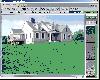 Landscape Vision: Windows Landscape Design with over 1000 photorealistic plant images. Landscape Vision's plant data base has been rated "Best Plant Data Base" 5 years in a row, by Top Ten Reviews! Our plant bios are informative, our images are crisp and clear, and the program is easy to use even...
Platforms: Windows
| License: Demo | Cost: $0.00 USD | Size: 31.47 MB | Download (942): Landscape Vision Download |
Added: February 21, 2010 | Visits: 1.120
 Vision Egg project is a high level interface between Python and OpenGL. In addition to methods for automatic generation of traditional visual stimuli such as sinusoidal gratings and random dot patterns, it has a number of functions for moving numeric data, images, movies, text, and 3D objects...
Platforms: *nix
| License: Freeware | Size: 1024 KB | Download (97): Vision Egg Download |
Added: May 08, 2010 | Visits: 884
GEO project is a C++ geometric template class library. Use this library for your graphical, image processing, or scientific applications. GEO has rich set of operations with vectors and matrices, 2D and 3D objects (such as finding convex hull, bounding box), triangulation, tesselation, etc..
Platforms: *nix
| License: Freeware | Size: 29.7 KB | Download (119): GEO Download |
Added: January 09, 2010 | Visits: 1.134
Geo::Lookup::ByTime is a Perl module to lookup location by time. SYNOPSIS use Geo::Lookup::ByTime; $lookup = Geo::Lookup::ByTime->new( @points ); my $pt = $lookup->nearest( $tm ); Given a set of timestamped locations guess the location at a particular time. This is a useful operation...
Platforms: *nix
| License: Freeware | Size: 15.36 KB | Download (94): Geo::Lookup::ByTime Download |
Added: October 01, 2010 | Visits: 1.093
Geo::Raster is a Perl extension for raster algebra. SYNOPSIS use Geo::Raster; or use Geo::Raster qw(:types); or use Geo::Raster qw(:types :logics :db); Geo::Raster is an object-oriented interface to libral, a C library for rasters and raster algebra. Geo::Raster makes using libral easy...
Platforms: *nix
| License: Freeware | Size: 89.09 KB | Download (108): Geo::Raster Download |
Added: June 09, 2010 | Visits: 1.184
Geo::Shapelib is a Perl extension for reading and writing shapefiles as defined by ESRI. SYNOPSIS use Geo::Shapelib qw/:all/; or use Geo::Shapelib qw/:all/; my $shapefile = new Geo::Shapelib { Name => stations, Shapetype => POINT, FieldNames => [Name,Code,Founded]; FieldTypes =>...
Platforms: *nix
| License: Freeware | Size: 266.24 KB | Download (133): Geo::Shapelib Download |
Added: April 26, 2010 | Visits: 1.376
Geo::Coder::Yahoo is a Perl module with geocode addresses with the Yahoo! API. SYNOPSIS Provides a thin Perl interface to the Yahoo! Geocoding API. use Geo::Coder::Yahoo; my $geocoder = Geo::Coder::Yahoo->new(appid => my_app ); my $location = $geocoder->geocode( location => Hollywood and...
Platforms: *nix
| License: Freeware | Size: 5.12 KB | Download (109): Geo::Coder::Yahoo Download |
Added: May 21, 2010 | Visits: 1.906
Geo::KML::PolyMap is a Perl module to generate KML/KMZ-format choropleth (shaded polygonal) maps viewable in Google Earth. SYNOPSIS use Geo::KML::PolyMap qw(generate_kml_file generate_kmz_file); # Clusters "Total Population" data for "Foobar City" in $entities into 5 bins; # renders using...
Platforms: *nix
| License: Freeware | Size: 11.26 KB | Download (399): Geo::KML::PolyMap Download |
Added: September 02, 2010 | Visits: 2.488
Geo::ShapeFile is a Perl extension for handling ESRI GIS Shapefiles. SYNOPSIS use Geo::ShapeFile; my $shapefile = new Geo::ShapeFile("roads"); for(1 .. $shapefile->shapes()) { my $shape = $shapefile->get_shp_record($_); # see Geo::ShapeFile::Shape docs for what to do with $shape my...
Platforms: *nix
| License: Freeware | Size: 276.48 KB | Download (147): Geo::ShapeFile Download |
Added: March 07, 2010 | Visits: 1.050
Geo::Coder::YahooJapan is a simple wrapper for Yahoo Japan Geocoder API. SYNOPSIS use Geo::Coder::YahooJapan; $r = lookup( $address_in_japanese_characters ); my ($lat, $lng) = ( $r->{latitude}, $r->{longitude} ); # coordinate in WGS87. # if you want to get result in TOKYO datum, specify...
Platforms: *nix
| License: Freeware | Size: 4.1 KB | Download (98): Geo::Coder::YahooJapan Download |
Added: May 25, 2010 | Visits: 1.300
Geo::TigerLine::Record::B is a TIGER/Line 2003 Polygon Geographic Entity Codes: Corrections. SYNOPSIS use Geo::TigerLine::Record::B; @records = Geo::TigerLine::Record::B->parse_file($fh); @records = Geo::TigerLine::Record::B->parse_file($fh, &callback); $record =...
Platforms: *nix
| License: Freeware | Size: 40.96 KB | Download (95): Geo::TigerLine::Record::B Download |
Added: March 10, 2010 | Visits: 1.221
Geo::Spline is a Perl module to calculate geographic locations between GPS fixes. SYNOPSIS use Geo::Spline; my $p0={time=>1160449100.67, #seconds lat=>39.197807, #degrees lon=>-77.263510, #degrees speed=>31.124, #m/s heading=>144.8300}; #degrees clockwise from North my...
Platforms: *nix
| License: Freeware | Size: 20.48 KB | Download (141): Geo::Spline Download |
Added: March 03, 2010 | Visits: 1.358
Geo::Inverse is a Perl module to calculate geographic distance from a lat & lon pair. SYNOPSIS use Geo::Inverse; my $obj = Geo::Inverse->new(); # default "WGS84" my ($lat1,$lon1,$lat2,$lon2)=(38.87, -77.05, 38.95, -77.23); my ($faz, $baz, $dist)=$obj->inverse($lat1,$lon1,$lat2,$lon2);...
Platforms: *nix
| License: Freeware | Size: 4.1 KB | Download (152): Geo::Inverse Download |
Added: September 13, 2010 | Visits: 895
Geo::Ellipsoids is a package for standard Geo:: ellipsoid a, b, f and 1/f values. SYNOPSIS use Geo::Ellipsoids; my $obj = Geo::Ellipsoids->new(); $obj->set(WGS84); #default print "a=", $obj->a, "n"; print "b=", $obj->b, "n"; print "f=", $obj->f, "n"; print "i=", $obj->i, "n"; print...
Platforms: *nix
| License: Freeware | Size: 7.17 KB | Download (109): Geo::Ellipsoids Download |
Added: February 03, 2010 | Visits: 1.855
Geo::ECEF is a Perl module that converts between ECEF (earth centered earth fixed) coordinates and latitude, longitude and height above ellipsoid. SYNOPSIS use Geo::ECEF; my $obj=Geo::ECEF->new(); #WGS84 is the default my ($x, $y, $z)=$obj->ecef(39.197807, -77.108574, 55); #Lat (deg), Lon...
Platforms: *nix
| License: Freeware | Size: 5.12 KB | Download (184): Geo::ECEF Download |
Added: January 14, 2010 | Visits: 1.377
TunnelVision creates an encrypted VirtualPrivateNetwork, or VPN, between two Tunnel Vision-capable sites on the Internet. TunnelVision creates an encrypted VirtualPrivateNetwork?, or VPN, between two Tunnel Vision-capable sites on the Internet. Realistically, that means sites with a Linux...
Platforms: *nix
| License: Freeware | Size: 101.38 KB | Download (121): Tunnel Vision Download |
Added: October 25, 2010 | Visits: 969
Geo::Coordinates::VandH is a Perl module that can convert and manipulate telco V and H coordinates. SYNOPSIS To convert V: 5498 H: 2895 to lat/long coordinates: use Geo::Coordinates::VandH; $blah=new Geo::Coordinates::VandH; ($lat,$lon) = $blah->vh2ll(5498,2895); printf...
Platforms: *nix
| License: Freeware | Size: 4.1 KB | Download (115): Geo::Coordinates::VandH Download |