


Garmin Gps Units software
Garmin Gps Units
Added: August 18, 2008 | Visits: 1.350
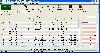 Allows you to connect your hand held Global Positioning System (GPS) unit to your computer, download your waypoints, and plot them in AutoCAD or export them in .dxf Also plots the points on free public domain Aerial photos and topo maps. Works on most Garmin and Magellan GPS units, and AutoCAD...
Platforms: Windows
| License: Shareware | Cost: $345.00 USD | Size: 9.9 MB | Download (543): GPS2CAD Download |
Added: November 12, 2010 | Visits: 1.392
 802.11b Network Discovery Tools is a gtk tool to scan for 802.11b networks using wavelan/aironet hardware and Linux wireless extensions. It includes the ability to log coordinates of found networks from a GPS device that is NMEA-compatible, and can be linked to a serial port. It currently logs...
Platforms: *nix
| License: Freeware | Size: 34.82 KB | Download (127): 802.11b Network Discovery Tools Download |
Added: January 25, 2010 | Visits: 874
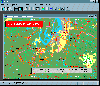
Terrabrowser is an internet browser for satellite photos and topographical maps which are obtained from the Microsoft Terra Server. The map data is provided by the U.S. Geological Survey (USGS) and therefore only covers the United States at this time (although expansion to other map servers may...
Platforms: Mac
| License: Shareware | Cost: $0.00 USD | Download (98): Terrabrowser Download |
Added: January 25, 2010 | Visits: 1.033
TrailRunner is a route planning software for all kinds of long distance sports like running, biking, hiking, inline-skating, skiing and more. If you ever asked yourself how long your workout routes are and what route you should choose for this evening - then TrailRunner should be your...
Platforms: Mac
| License: Freeware | Download (123): TrailRunner Download |
Released: August 21, 2012
|
Added: August 21, 2012 | Visits: 426
 AGIS for Windows is a mapping and simple GIS shareware package. Plot your own geographic data on the map of the world provided without the high cost and steep learning curve usually associated with this kind of software. Create high resolution publication quality images that can be pasted into...
Platforms: Windows
| License: Shareware | Cost: $49.00 USD | Size: 3.57 MB | Download (478): AGIS for Windows Download |
Released: October 11, 2012
|
Added: October 11, 2012 | Visits: 402
EPS is a moving map project. If can use GPS units (currently GARMIN).
Platforms: Windows, Mac, Linux
| License: Freeware | Size: 1.26 MB | Download (44): EPS - The Elgaard Positioning System Download |
Released: December 18, 2012
|
Added: December 18, 2012 | Visits: 439
 POI Loader is free software for your computer that lets you upload customized points of interest (POIs) to your compatible Garmin device. With the help of POI Loader, you can update your compatible Garmin GPS with the latest POIs, including restaurants, s
Platforms: Mac
| License: Freeware | Size: 9.5 MB | Download (56): POI Loader Download |
Added: June 26, 2013 | Visits: 340
HRV tracker is designed to log R-R intervals from an ANT-compatible heart rate strap. This application can receive data from either a serial-port ANT receiver device (e.g.: the SparkFun ANT USB stick) or the ANT USB receiver stick that ships with many ANT-compatible heart rate monitors and GPS...
Platforms: Mac
| License: Shareware | Cost: $0.00 USD | Size: 409.6 KB | Download (40): HRV tracker Download |
Added: November 23, 2013 | Visits: 574
GiPSy Flight Manager is an extension for FireFox web browser that provides: * downloading flight tracklogs from your GPS instrument and creating IGC in a very easy and intuitive way * well arranged and usable logbook of all your flights * route optimization - you can compute the best route...
Platforms: Mac
| License: Freeware | Size: 7.61 MB | Download (83): GiPSy Flight Manager Download |
Added: November 19, 2013 | Visits: 357
HRV tracker is designed to log R-R intervals from an ANT-compatible heart rate strap. This application can receive data from either a serial-port ANT receiver device (e.g.: the SparkFun ANT USB stick) or the ANT USB receiver stick that ships with many ANT-compatible heart rate monitors and GPS...
Platforms: Mac
| License: Shareware | Cost: $0.00 USD | Size: 71.68 KB | Download (38): HRV tracker Beta Download |
Released: November 23, 2012
|
Added: November 23, 2012 | Visits: 257
With OpenStreetMap.org, you can export maps (for free) in XML OSM format. These maps are pretty handy - but if you want to load them onto your GPS, this free utility will allow you to easily convert the OSM files to IMG files which you can import into your Garmin GPS.
Platforms: Mac
| License: Freeware | Size: 2.5 MB | Download (511): OSMtoIMG for Mac OS Download |
Released: September 07, 2012
|
Added: September 07, 2012 | Visits: 474
A powerful and flexible journal application that allows all levels of athletes and fitness enthusiasts to get the most from their training and racing. It allows you to easily and quickly track your training, monitor your progress, and built a history of your training. You can manually enter your...
Platforms: Mac
| License: Freeware | Size: 20 MB | Download (485): iSMARTtrain for Mac OS Download |
Released: September 21, 2012
|
Added: September 21, 2012 | Visits: 697
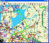 PocketFMS is the Moving Map and Flight Planning tool for PC, Tablet PC, UMPC, Pocket PC and Windows CE-based Car Navigation equipment. It comprises downloadable, worldwide maps, access to a comprehensive AeroDatabase, integrated & graphical weather with 48 hours prognosis, TCAS info and...
Platforms: Windows, Pocket PC
| License: Freeware | Size: 34.55 MB | Download (65): PocketFMS Download |
Released: September 24, 2012
|
Added: September 24, 2012 | Visits: 437
 Paralog is the world's leading skydiving logbook and flight analysis software made by skydivers for skydivers - and BASE jumpers!.
Paralog downloads jump details from all electronic freefall loggers on the market: Neptune by Alti-2, ProTrack and AltiTrack by Larsen & Brusgaard and Skytronic...
Paralog is the world's leading skydiving logbook and flight analysis software made by skydivers for skydivers - and BASE jumpers!.
Paralog downloads jump details from all electronic freefall loggers on the market: Neptune by Alti-2, ProTrack and AltiTrack by Larsen & Brusgaard and Skytronic...
Platforms: Linux
| License: Demo | Cost: $49.95 USD | Size: 7 MB | Download (538): Paralog for Linux Download |
Released: September 07, 2012
|
Added: September 07, 2012 | Visits: 515
 Paralog is the world's leading skydiving logbook and flight analysis software made by skydivers for skydivers - and BASE jumpers!.
Paralog downloads jump details from all electronic freefall loggers on the market: Neptune by Alti-2, ProTrack and AltiTrack by Larsen & Brusgaard and Skytronic...
Paralog is the world's leading skydiving logbook and flight analysis software made by skydivers for skydivers - and BASE jumpers!.
Paralog downloads jump details from all electronic freefall loggers on the market: Neptune by Alti-2, ProTrack and AltiTrack by Larsen & Brusgaard and Skytronic...
Platforms: Mac
| License: Demo | Cost: $49.95 USD | Size: 8.5 MB | Download (525): Paralog for Mac OS X Download |
Released: September 23, 2012
|
Added: September 23, 2012 | Visits: 455
 Paralog is the world's leading skydiving logbook and flight analysis software made by skydivers for skydivers - and BASE jumpers!.
Paralog downloads jump details from all electronic freefall loggers on the market: Neptune by Alti-2, ProTrack and AltiTrack by Larsen & Brusgaard and Skytronic...
Paralog is the world's leading skydiving logbook and flight analysis software made by skydivers for skydivers - and BASE jumpers!.
Paralog downloads jump details from all electronic freefall loggers on the market: Neptune by Alti-2, ProTrack and AltiTrack by Larsen & Brusgaard and Skytronic...
Platforms: Windows
| License: Demo | Cost: $49.95 USD | Size: 8.5 MB | Download (537): Paralog Download |
Released: October 23, 2012
|
Added: October 23, 2012 | Visits: 391
Converts Google Earth KML file to a CSV file, and vice versa. This enables you to plot all custom POIs with Google Earth first before transferring them into your Garmin GPS using the POI Loader.
Platforms: Windows, Mac, BSD, Linux
| License: Freeware | Size: 273.25 KB | Download (43): KMLCSV Converter Download |
Added: May 24, 2013 | Visits: 336
The Olin Robotics Blockset for xPC Target is a set of xPC Target drivers for common robotics devices. The supported devices are:Garmin GPS 18-5Hz (Consumer GPS)NAVCOM SF-2050G (Precision GPS)Microstrain 3DM-GX1 (INS)SICK LMS 291-S05 (LIDAR up to 500Kbps, any operation requires Fastcom...
Platforms: Matlab
| License: Shareware | Cost: $0.00 USD | Size: 4.15 MB | Download (45): Olin Robotics Blockset for xPC Target Download |
Released: August 26, 2012
|
Added: August 26, 2012 | Visits: 609
The Garmin Phase Output protocol gives software developers the ability to upload and download data from Garmin devices. The Garmin Phase Output plug-in for GPS.NET makes working with Garmin devices easy by handing all of the complicated device communications for you. Upload and download...
Platforms: Windows
| License: Shareware | Cost: $39.00 USD | Size: 4.64 MB | Download (47): Garmin Phase Output Plug-In for GPS.NET Download |
Added: August 19, 2013 | Visits: 493
Download NMEA Data From Garmin Etrex Vista GPS1-SELECT PORT.2-PUSH "START RECEIVING" BUTTON.3-SET DESTINATION FOR TXT FILE.4-AT THE END,PUSH "STOP RECEIVING".
Platforms: Matlab
| License: Shareware | Cost: $0.00 USD | Size: 20.48 KB | Download (40): Receive NMEA From Garmin Etrex vista GPS Download |