


Garmin Aviation Gps software
Garmin Aviation Gps
Released: July 10, 2012
|
Added: July 10, 2012 | Visits: 423
 Allows you to transfer track log and waypoint data from your Garmin, Magellan or Wintec GPS devices. It connects via USB to the Garmin and Magellan devices. It interfaces with the Wintec WBT-100, WBT-101 and WBT-201 devices using Bluetooth.
HoudahGPS may also be used to convert between the GPX,...
Platforms: Mac
Allows you to transfer track log and waypoint data from your Garmin, Magellan or Wintec GPS devices. It connects via USB to the Garmin and Magellan devices. It interfaces with the Wintec WBT-100, WBT-101 and WBT-201 devices using Bluetooth.
HoudahGPS may also be used to convert between the GPX,...
Platforms: Mac
| License: Freeware | Size: 1.3 MB | Download (53): HoudahGPS for Mac OS Download |
Released: June 13, 2012
|
Added: June 13, 2012 | Visits: 729
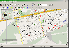
 View maps of Earth and other planets with PrettyMap! See current day and night regions, learn geography by taking the quiz, enjoy 3D elevation surfaces, measure distances between locations and create your own maps with special places! PrettyMap lets you view vector and raster maps and images...
Platforms: Windows, Pocket PC
View maps of Earth and other planets with PrettyMap! See current day and night regions, learn geography by taking the quiz, enjoy 3D elevation surfaces, measure distances between locations and create your own maps with special places! PrettyMap lets you view vector and raster maps and images...
Platforms: Windows, Pocket PC
| License: Shareware | Cost: $19.95 USD | Size: 4.02 MB | Download (56): PrettyMap - World Atlas and Maps, GPS Download |
Released: August 24, 2012
|
Added: August 24, 2012 | Visits: 558
 The GPSMapEdit software was designed for visual authoring of GPS-maps in various proprietary cartographic formats. GPSMapEdit will help you work with Garmin MapSource, Polish format (input files for cGPSmapper.exe), ALAN Map 500/600, Holux, Navitel Navigator (Pocket PC navigation software).
Platforms: Windows
The GPSMapEdit software was designed for visual authoring of GPS-maps in various proprietary cartographic formats. GPSMapEdit will help you work with Garmin MapSource, Polish format (input files for cGPSmapper.exe), ALAN Map 500/600, Holux, Navitel Navigator (Pocket PC navigation software).
Platforms: Windows
| License: Demo | Cost: $65.00 USD | Size: 2.4 MB | Download (54): GPSMapEdit Portable Download |
Released: June 20, 2012
|
Added: June 20, 2012 | Visits: 540
 The GPSMapEdit software was designed for visual authoring of GPS-maps in various proprietary cartographic formats. GPSMapEdit will help you work with Garmin MapSource, Polish format (input files for cGPSmapper.exe), ALAN Map 500/600, Holux, Navitel Navigator (Pocket PC navigation software).
Platforms: Windows
The GPSMapEdit software was designed for visual authoring of GPS-maps in various proprietary cartographic formats. GPSMapEdit will help you work with Garmin MapSource, Polish format (input files for cGPSmapper.exe), ALAN Map 500/600, Holux, Navitel Navigator (Pocket PC navigation software).
Platforms: Windows
| License: Demo | Cost: $65.00 USD | Size: 2.4 MB | Download (51): GPSMapEdit Download |
Released: September 21, 2012
|
Added: September 21, 2012 | Visits: 430
 GPS/J is a console for all Bluetooth-enabled GPS receivers (now with 20000 European towns and cities!), a mobile navigation tool for cellular phone owners and the most affordable and convenient way to use location services.
It is a J2ME application for JSR82-compliant devices, which means...
GPS/J is a console for all Bluetooth-enabled GPS receivers (now with 20000 European towns and cities!), a mobile navigation tool for cellular phone owners and the most affordable and convenient way to use location services.
It is a J2ME application for JSR82-compliant devices, which means...
| License: Demo | Cost: $0.00 USD | Size: 281 KB | Download (48): GPS/J Download |
Released: November 15, 2012
|
Added: November 15, 2012 | Visits: 440
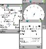
GPS Express provides a feature rich interface to serial NMEA-0183 protocol data and works with most NMEA-0183 devices, including GPS Receivers. GPS Express is available in three versions (Standard, Professional, Graphical). STANDARD displays the title, value, and units for each parameter....
Platforms: Windows
| License: Shareware | Cost: $65.00 USD | Size: 2.1 MB | Download (48): GPS Express Standard Edition 3.x Download |
Released: July 20, 2012
|
Added: July 20, 2012 | Visits: 469
GPS Express provides a feature rich interface to serial NMEA-0183 protocol data and works with most NMEA-0183 devices, including GPS Receivers. GPS Express is available in three versions (Standard, Professional, Graphical). STANDARD displays the title, value, and units for each parameter....
Platforms: Windows
| License: Shareware | Cost: $30.00 USD | Size: 2.1 MB | Download (47): GPS Express 3.x Download |
Released: August 25, 2012
|
Added: August 25, 2012 | Visits: 635
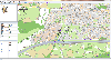 GPS Mapping Software for Windows, Loading topographic maps, realtime navigation, track recording, manage GPS devices and more. The software can be used with various map formats including: GeoTiff, BSB Nautical Charts, AutoCad DXF files, ESRI Shapefiles. Using calibration you can also use scanned...
Platforms: Windows
GPS Mapping Software for Windows, Loading topographic maps, realtime navigation, track recording, manage GPS devices and more. The software can be used with various map formats including: GeoTiff, BSB Nautical Charts, AutoCad DXF files, ESRI Shapefiles. Using calibration you can also use scanned...
Platforms: Windows
| License: Shareware | Cost: $149.00 USD | Size: 11.13 MB | Download (48): Eye4Software GPS Mapping Studio Download |
Released: December 05, 2012
|
Added: December 05, 2012 | Visits: 329
 Toolkit to add GPS functionality to software. All NMEA0183 protocol versions are supported, all NMEA 0183 can be filtered by NMEA type and talker ID. Values can be outputed using different output formats and units. Information on GPS status can also be retrieved: GPS fix quality, Satellites used...
Platforms: Windows
Toolkit to add GPS functionality to software. All NMEA0183 protocol versions are supported, all NMEA 0183 can be filtered by NMEA type and talker ID. Values can be outputed using different output formats and units. Information on GPS status can also be retrieved: GPS fix quality, Satellites used...
Platforms: Windows
| License: Shareware | Cost: $99.00 USD | Size: 373 KB | Download (43): Eye4Software GPS Toolkit Download |
Released: October 23, 2012
|
Added: October 23, 2012 | Visits: 572
 Use GPS without GPS receiver! Try this advanced GPS device simulator (virtual GPS receiver). It can be used for development purposes or for testing GPS software before buying. Generates NMEA messages from different data inputs (map or file). Generated NMEA data can be used by mapping or other GPS...
Platforms: Windows
Use GPS without GPS receiver! Try this advanced GPS device simulator (virtual GPS receiver). It can be used for development purposes or for testing GPS software before buying. Generates NMEA messages from different data inputs (map or file). Generated NMEA data can be used by mapping or other GPS...
Platforms: Windows
| License: Shareware | Cost: $39.99 USD | Size: 800 KB | Download (534): Avangardo GPS generator PRO Download |
Released: August 17, 2012
|
Added: August 17, 2012 | Visits: 548
 Bored with alarms firing in the wrong place? GPS-Action will fire reminder exactly when you reach the target place, no sooner and no later! Depending on your geographical location GPS-Action will fire alarm, open the application, change profile, launch the website, open a document or a certain...
Platforms: Symbian
Bored with alarms firing in the wrong place? GPS-Action will fire reminder exactly when you reach the target place, no sooner and no later! Depending on your geographical location GPS-Action will fire alarm, open the application, change profile, launch the website, open a document or a certain...
Platforms: Symbian
| License: Shareware | Cost: $9.99 USD | Size: 466 KB | Download (508): GPS-Action Download |
Released: November 22, 2012
|
Added: November 22, 2012 | Visits: 540
 mdNavMobile is a waypoint-based GPS navigation solution for the Windows Mobile platform. It can guide you from waypoint to waypoint while keeping you informed of all relevant navigation data. All NMEA-data from a GPS is automatically logged to file so you can 'replay' a trip with variable speed....
Platforms: Windows, Pocket PC, Handheld/Mobile Other
mdNavMobile is a waypoint-based GPS navigation solution for the Windows Mobile platform. It can guide you from waypoint to waypoint while keeping you informed of all relevant navigation data. All NMEA-data from a GPS is automatically logged to file so you can 'replay' a trip with variable speed....
Platforms: Windows, Pocket PC, Handheld/Mobile Other
| License: Freeware | Size: 30 KB | Download (48): mdNavMobile Download |
Released: December 22, 2012
|
Added: December 22, 2012 | Visits: 471
 Run.GPS Trainer UV is the perfect tool to take along doing all sorts of sports like running, skiing, hiking, and many more. Run.GPS Trainer UV is compatible with most PocketPCs and Smartphones (requires Windows Mobile 2003 Pocket PC, Windows Mobile 5 or Windows Mobile 6). Recording *...
Platforms: Windows, Pocket PC
Run.GPS Trainer UV is the perfect tool to take along doing all sorts of sports like running, skiing, hiking, and many more. Run.GPS Trainer UV is compatible with most PocketPCs and Smartphones (requires Windows Mobile 2003 Pocket PC, Windows Mobile 5 or Windows Mobile 6). Recording *...
Platforms: Windows, Pocket PC
| License: Shareware | Cost: $33.99 USD | Size: 6.29 MB | Download (606): Run.GPS Trainer UV Download |
Released: July 11, 2012
|
Added: July 11, 2012 | Visits: 379
FlightTrack is a 2D/3D GPS track viewing software for light aviation pilots using MacOS X.
Platforms: Mac
| License: Freeware | Size: 6.09 KB | Download (43): FlightTrack Download |
Released: November 05, 2012
|
Added: November 05, 2012 | Visits: 314
Java base GPS Waypoint manipulation.Provides a toolkit for managing a variety of GPS Waypoint input formats like GPX, used by ExpertGPS and GeoCaching.com, as well as conversion formats for certain GPS devices.Similar in goals to gpsbabel.
Platforms: Windows, Mac, Linux
| License: Freeware | Size: 4.58 MB | Download (43): GPS Blender Download |
Released: July 13, 2012
|
Added: July 13, 2012 | Visits: 497
 The gpstoolbox project provides a portable Garmin GPS (Global Positioning System) interface library and associated utilities to support creating, transfering, and processing of route, track log, waypoint, and PVT data. Supported platforms include Linux,
Platforms: Windows, Mac, Linux
The gpstoolbox project provides a portable Garmin GPS (Global Positioning System) interface library and associated utilities to support creating, transfering, and processing of route, track log, waypoint, and PVT data. Supported platforms include Linux,
Platforms: Windows, Mac, Linux
| License: Freeware | Size: 245.55 KB | Download (48): gpstoolbox Download |
Released: June 08, 2012
|
Added: June 08, 2012 | Visits: 398
 Substitutes the missing GPS information in Garmin TCX files when devices lacking a GPS receiver are used to collect training data (Garmin FR 60, heartrate and pedometer only). GpxTcxWelder integrates GPS info from a GPX v1.1 files into TCX files
Platforms: Windows, Mac, Linux
Substitutes the missing GPS information in Garmin TCX files when devices lacking a GPS receiver are used to collect training data (Garmin FR 60, heartrate and pedometer only). GpxTcxWelder integrates GPS info from a GPX v1.1 files into TCX files
Platforms: Windows, Mac, Linux
| License: Freeware | Size: 3.02 MB | Download (50): GpxTcxWelder Download |
Released: October 25, 2012
|
Added: October 25, 2012 | Visits: 326
A very basic, very simple Java based GPS tool. Reads NMEA from GPS device over serial port - and does a few usefull things with it. The goal is to have something that can run and be useful on a desktop, laptop and handheld device.
Platforms: Windows, Mac, Linux
| License: Freeware | Size: 1.33 MB | Download (48): KISS GPS Download |
Released: July 11, 2012
|
Added: July 11, 2012 | Visits: 579
 Preparation of GPS routes and analysis of GPS logs in the context of outdoor sports (biking, skiing, trecking, gliding, geocaching, mountaineering). Our hope is to have a multi platform, multi GPS file and map format software.
Platforms: Windows, Mac, BSD, Linux
Preparation of GPS routes and analysis of GPS logs in the context of outdoor sports (biking, skiing, trecking, gliding, geocaching, mountaineering). Our hope is to have a multi platform, multi GPS file and map format software.
Platforms: Windows, Mac, BSD, Linux
| License: Freeware | Size: 6.18 MB | Download (50): Le Petit Poucet gps software Download |
Released: June 18, 2012
|
Added: June 18, 2012 | Visits: 638
OpenGTS (Open Source GPS Tracking System) is a full featured web-based GPS tracking system for your fleet of vehicles. It supports OpenLayers and other map providers, detail/summary Reporting, and various GPS tracking devices.
Platforms: Windows, Mac, BSD, Linux
| License: Freeware | Size: 4.27 MB | Download (46): Open GPS Tracking System Download |