


Earth Satellite Maps Usa software
Earth Satellite Maps Usa
Released: July 01, 2012
|
Added: July 01, 2012 | Visits: 505
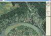
 Can you imagine how large an satellite image is, which has dimensions of 86400 pixels wide and 43200 pixels high?This is a simple article which describes the Worlds Largest Satellite Images.See the largest satellite images using a free software which is included inside.This free software will...
Platforms: Windows
| License: Freeware | Size: 590 KB | Download (523): Largest Satellite Images Download |
Released: October 16, 2012
|
Added: October 16, 2012 | Visits: 1.010
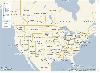
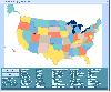
 USA Real Estate Map Pro is a premium class software for mapping: real estate properties, contact listings, offices and other geo spatial data. Interactive Real Estate map is rather simple to integrate with database listings: both to specify the states and counties that should be active on map,...
Platforms: Windows, Mac, OS/2, Unix, Linux, MS-DOS, AS/400
| License: Shareware | Cost: $399.00 USD | Size: 10.42 MB | Download (520): USA Real Estate Map Pro Download |
Released: August 22, 2012
|
Added: August 22, 2012 | Visits: 371
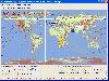
With yalips maps you get 4 products in 1. You are more productive, more creative and perform better on your job when using visual software tools. With the resulting visualizations you can communicate more effectively and convincingly to your collegues, your boss, your customer or the chairman of...
Platforms: Windows
| License: Shareware | Cost: $80.00 USD | Size: 29.65 MB | Download (512): yalips maps Download |
Released: June 13, 2012
|
Added: June 13, 2012 | Visits: 937
 Add realistic 3D capabilities to your online Bing Maps. Bing Maps 3D brings you another step closer to knowing "what it is like out there". You can search, browse, and organize local information viewed in three dimensions, just the way it exists in the real world. This enables you to more...
Platforms: Windows
| License: Freeware | Size: 1.2 MB | Download (511): Microsoft Bing Maps 3D Download |
Added: September 13, 2006 | Visits: 2.543
 You are a pilot of space interceptor bound back to Earth in order to give the captured alien spacecraft into the hands of scientists. The aliens are trying to stop you from doing this by sending a huge armada of their battleships. You have to destroy them all to accomplish your mission. You’ll...
Platforms: Windows
| License: Shareware | Cost: $14.95 USD | Size: 3.68 MB | Download (507): Back To Earth Download |
Released: August 19, 2012
|
Added: August 19, 2012 | Visits: 1.063
 Satellite TV PC Master is a leading computer TV software that turns your computer into a Super Pro TV. easy to use PC program that legally streams thousands of quality television and radio channels from all over the world directly to your computer using the internet. Now you can watch thousands...
Platforms: Windows
| License: Shareware | Cost: $49.95 USD | Size: 16 MB | Download (498): Satellite TV PC Master Download |
Released: July 10, 2012
|
Added: July 10, 2012 | Visits: 826
Amazing PC TV Player offering 3.000+ TV channels, 2.000+ Movies on Demand and 1.000+ Radio stations. Watch TV from all over the world (150 countries, 32 languages) and watch full length movies with online streaming technology (no download required). This is the only PC TV Player with daily...
Platforms: Windows
| License: Shareware | Cost: $29.95 USD | Size: 15.21 MB | Download (475): Satellite TV Media Player Download |
Added: June 07, 2006 | Visits: 3.064
 Interactive France departments flash maps. With this fully-clickable map you will be able to improve navigation and provide visitors with better and quicker access to information as well as improve the way you present the information. The map can be used "as is" however it is also easily...
Platforms: Windows
| License: Demo | Cost: $24.90 USD | Size: 310 KB | Download (469): Flash Maps France Departments Download |
Released: December 07, 2012
|
Added: December 07, 2012 | Visits: 527
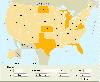
 USA Flash Map Locator for websites, presentations and more. Easy adjustment.
Variants of using a map locator:
- Real-Estate websites
- Quick access to contact organization data, having affiliated network in USA
With this fully-clickable map you will be able to improve navigation and provide...
USA Flash Map Locator for websites, presentations and more. Easy adjustment.
Variants of using a map locator:
- Real-Estate websites
- Quick access to contact organization data, having affiliated network in USA
With this fully-clickable map you will be able to improve navigation and provide...
Platforms: Windows, Mac
| License: Demo | Cost: $69.00 USD | Size: 64 KB | Download (469): USA Map Locator Download |
Released: October 14, 2012
|
Added: October 14, 2012 | Visits: 388
 This program is designed to predict the tracks of satellites both as paths above the earth, and as images produced by these satellites when scanning the ground. It was designed for use during the early stages of my weather satellite receiving activities, when clouds and interference prevented...
Platforms: Windows
| License: Demo | Cost: $28.95 USD | Size: 1.5 MB | Download (465): WXtrack Download |
Released: January 09, 2003
|
Added: October 07, 2006 | Visits: 3.319
USA Online package contains full featured HTML website template with source Adobe Photoshop graphics. It's the easiest and most affordable way to create or professionally re-design your American website. It suits any website related with United States and Americans.
Platforms: Windows, Mac
| License: Commercial | Cost: $45.00 USD | Size: 626 KB | Download (456): USA Online Download |
Released: January 02, 2013
|
Added: January 02, 2013 | Visits: 688
 SkyGrabber is offline satellite internet downloader. It intercepts satellite data( movie, music, pictures ) that downloadind by other users and saves information in your hard disk. So, you'll get new movie, best music and funny pictures for free. You don't have to keep an online internet...
Platforms: Windows
| License: Shareware | Cost: $25.95 USD | Size: 3.7 MB | Download (455): SkyGrabber Download |
Released: November 23, 2006
|
Added: November 23, 2006 | Visits: 6.060
 The program StitchMaps simply joins these maps.
The result is a map that is suitable for programs using raster scan.
The maps used as basis for the assembly were either created by scanning templates, or by exports from digitalized maps.
The program is available as standard and as plus...
The program StitchMaps simply joins these maps.
The result is a map that is suitable for programs using raster scan.
The maps used as basis for the assembly were either created by scanning templates, or by exports from digitalized maps.
The program is available as standard and as plus...
Platforms: Windows
| License: Shareware | Cost: $45.00 USD | Size: 554.8 KB | Download (454): StitchMaps Download |
Released: August 23, 2012
|
Added: August 23, 2012 | Visits: 665
 All-in-one software for creation of custom GPS maps compatible with Garmin GPS units. Mapwel supports routing, ESRI shapefiles, OpenStreetMap OSM, Google Earth KML and KMZ, cGPSmapper MP and GPX files. Mapwel custom GPS mapping capability and user icons editor are often used in forestry,...
Platforms: Windows
| License: Shareware | Cost: $45.00 USD | Size: 12.28 MB | Download (454): Mapwel Download |
Released: August 01, 2012
|
Added: August 01, 2012 | Visits: 568
 Drag and drop the country names of United States correctly onto the map.
Platforms: Windows
| License: Shareware | Cost: $19.99 USD | Size: 1.25 MB | Download (452): US Interactive Map Quiz Software Download |
Released: June 04, 2012
|
Added: June 04, 2012 | Visits: 471
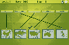 In this game there will be some country names and some maps of countries. Your task is to match the country names with the correct maps. You match them by using the mouse to draw a line to connect the dots of the country names and the maps. There are a total of 5 levels and each level will be...
Platforms: Windows
| License: Freeware | Size: 262 KB | Download (451): Mapping Maps Download |
Released: August 03, 2012
|
Added: August 03, 2012 | Visits: 487
 Using advanced mapping techniques, this AutoCAD plug-in gives you the ultimate interface to place your drawings in the real world. Plex.Earth connects AutoCAD with Google Earth and our Web Services in order to provide you a set of unique features. Enhance your design, boost your productivity and...
Platforms: Windows
| License: Shareware | Cost: $109.00 USD | Size: 2.93 MB | Download (448): Plex.Earth Tools for AutoCAD Download |
Released: October 21, 2009
|
Added: November 24, 2022 | Visits: 1.588
 Open Contacts is an advanced address book program for managing contact info of individuals and organizations with relationships. The program was designed for people who need more beyond legacy address book programs in order to improve dynamic interactions with contacts. With SyncML for Open...
Platforms: Windows, Windows 7
| License: Free | Cost: $0.00 USD | Size: 4.96 MB | Download (444): Open Contacts Download |
Released: August 14, 2012
|
Added: August 14, 2012 | Visits: 690
View your Analytics Georeports on a 3D Google Earth Globe in the integrated browser (which utilises the Google Earth Internet-Plugin) or export your data to a .kml file which you can import in the standalone version of Google Earth.Simply choose one of your Analytics profiles, specify a timeframe...
Platforms: Mac
| License: Freeware | Size: 931.84 KB | Download (441): Analytics to Earth for Mac OS Download |
Released: December 05, 2012
|
Added: December 05, 2012 | Visits: 842
 A driver restore disk works with a windows disk to return your Toshiba Satellite Pro A200-17L Windows 7 back to the original factory setup. Once windows has installed you put this disk into the drive as soon as windows gives you a found new hardware dialog box. Once inserted the Toshiba Satellite...
Platforms: Windows
| License: Shareware | Cost: $14.95 USD | Size: 625 MB | Download (433): Toshiba Satellite Pro A200-17L Windows 7 Drivers Download |