


Coordinate software
Coordinate
Added: August 05, 2008 | Visits: 4.758
 NetPumper is a download manager for those users who usually download programs, movies, songs, etc from the Internet, with the grand attraction of letting you coordinate multiple file downloads from the Internet simultaneously.You can restart interrupted downloads, and above all download the URL...
Platforms: Windows
| License: Freeware | Size: 3 KB | Download (4362): Netpumper Download |
Released: November 17, 2009
|
Added: April 17, 2010 | Visits: 2.519
 CopanMobile for Pocket PC is a very functional and easy-to-use geomatics engineering tool for computing and managing plane surveying and mapping coordinates.
It does numerous coordinate geometry (COGO) calculations, processes and adjusts raw field survey data, computes and adjusts map...
CopanMobile for Pocket PC is a very functional and easy-to-use geomatics engineering tool for computing and managing plane surveying and mapping coordinates.
It does numerous coordinate geometry (COGO) calculations, processes and adjusts raw field survey data, computes and adjusts map...
Platforms: Pocket PC, Windows
| License: Freeware | Size: 662.68 KB | Download (1153): CopanMobile for PocketPC Download |
Released: September 11, 2012
|
Added: September 30, 2012 | Visits: 756
 A CRM system for individuals & small groups, to share addresses, appointments and coordinate activities as a unit. Suitable for families, sales teams, fund raising, or any other group with a common objective that need to share customer and contact information including contact history. The system...
Platforms: Windows, *nix
| License: Demo | Cost: $0.00 USD | Size: 2.02 MB | Download (1016): ZPT CRM Download |
Released: December 22, 2011
|
Added: January 24, 2012 | Visits: 1.462
 Land surveyors and civil engineers:
o Calculate surveys and manage points, effortlessly
o Run Copan on Windows 2K/XP/Vista/7
o Use it forever and pay nothing
o Choose quadrant bearings or N/S azimuths, and gons or DMS
o Create point files quickly and easily
o Edit...
Land surveyors and civil engineers:
o Calculate surveys and manage points, effortlessly
o Run Copan on Windows 2K/XP/Vista/7
o Use it forever and pay nothing
o Choose quadrant bearings or N/S azimuths, and gons or DMS
o Create point files quickly and easily
o Edit...
Platforms: Windows
| License: Freeware | Size: 5.44 MB | Download (977): Copan Lite Download |
Released: September 14, 2011
|
Added: October 03, 2011 | Visits: 1.707
 For the implementation of the INSPIRE directive all so far in Germany available geo references with Gauss-Krueger / DHDN coordinates now must be converted to UTM / ETRS89 coordinates for future use. BetaDLL supports the development of geodetic software on various platforms for this...
Platforms: Windows, Mac, *nix, Windows CE, Pocket PC, iPhone,iPod,Palm,Handheld/Mobile Other,Java
| License: Shareware | Cost: $685.00 USD | Size: 1.04 MB | Download (854): BetaDLL Download |
Released: May 28, 2010
|
Added: June 04, 2010 | Visits: 2.695
 Copan for Windows desktop/netbook is a very functional and easy-to-use geomatics engineering tool for computing and managing plane land surveying and mapping coordinates.
It does numerous coordinate geometry (COGO) calculations, processes and adjusts raw field survey data, computes and...
Copan for Windows desktop/netbook is a very functional and easy-to-use geomatics engineering tool for computing and managing plane land surveying and mapping coordinates.
It does numerous coordinate geometry (COGO) calculations, processes and adjusts raw field survey data, computes and...
Platforms: Windows
| License: Freeware | Size: 5.28 MB | Download (824): Copan for Windows Download |
Released: October 01, 2010
|
Added: October 09, 2010 | Visits: 1.602
 GeoDataSource Cities Database Titanium Edition contains 3.1+ million entries with city names in original language and English, feature type classifications, country names in FIPS and ISO, regions, sub-regions, state or First-Order Administrative Division, county or Second-Order Administrative...
Platforms: OS/2, Windows, Mac, *nix, Palm OS, Windows CE, Pocket PC, Palm OS 3.5,Palm OS 4.1,Palm OS 5,Symbian,MS-DOS,BEOS
| License: Demo | Cost: $1649.95 USD | Size: 144.51 KB | Download (824): GeoDataSource World Cities Database Download |
Added: August 14, 2008 | Visits: 1.750
 CoordTrans converts geographic positions between different coordinate systems.Convert between UTM and WGS84.Convert between UTM and NAD27 / NAD83.And more... grids from 17 countries supported. Convert geographic coordinates (latitude / longitude) between different datums.
Platforms: Windows
| License: Shareware | Cost: $19.95 USD | Size: 669 KB | Download (744): CoordTrans Download |
Released: October 24, 2018
|
Added: June 27, 2019 | Visits: 1.299
 CADopia 18 Professional is a full-featured affordable CAD software with perpetual license for engineers, architects and other CAD professionals. CADopia 18 is available in 12 languages - Chinese, Czech, English, French, German, Italian, Japanese, Korean, Polish, Portuguese, Russian, and Spanish....
Platforms: Windows, Windows 8, Windows 7, Windows Server
| License: Demo | Cost: $545.00 USD | Size: 238.68 MB | Download (683): CADopia Professional Edition Download |
Released: December 05, 2012
|
Added: December 05, 2012 | Visits: 354
 Bento organizes all your important information in one place. So you can manage your contacts, track projects, coordinate events, prioritize tasks, and more faster and easier than ever before.
Bento takes advantage of many of the new features of Leopard, including live linking to iCal data,...
Bento organizes all your important information in one place. So you can manage your contacts, track projects, coordinate events, prioritize tasks, and more faster and easier than ever before.
Bento takes advantage of many of the new features of Leopard, including live linking to iCal data,...
Platforms: Mac
| License: Shareware | Cost: $49.00 USD | Size: 105.97 MB | Download (581): Bento Download |
Added: August 24, 2008 | Visits: 647
GEOPosCalc is an easy to use and powerfull tool for coordinate systems (grid) and datum conversion. It does support more than 200 predefined datums, 20 ellipsoids and 10 coordinate systemsand the ability to define your own datums and ellipsoids.
Platforms: Windows
| License: Shareware | Cost: $40.00 USD | Size: 4.79 MB | Download (578): GEOPosCalc Download |
Added: August 31, 2008 | Visits: 1.210
 In the Dynamic Link Library GeoDLL geodesic functions like 2D and 3D coordinate transformation, datum changes, meridian strip changes, user defined coordinate and reference systems, NTv2 support, distance calculation, maps functions, Digital Elevation Models and more geodesic functions are...
Platforms: Windows
| License: Shareware | Cost: $310.00 USD | Size: 1.03 MB | Download (519): GeoDLL (Deutsch) Download |
Released: November 12, 2012
|
Added: November 12, 2012 | Visits: 572
Asymptote is a powerful descriptive vector graphics language that provides a natural coordinate-based framework for technical drawing. Labels and equations are typeset with LaTeX, for high-quality PostScript output.Asymptote is a graphic tool that provides a standard for typesetting mathematical...
Platforms: Mac
| License: Freeware | Size: 3.7 MB | Download (482): Asymptote for Mac OS X Download |
Released: August 13, 2012
|
Added: August 13, 2012 | Visits: 687
Little Hopper's Treasure Hunt is a fun introduction to graphing and the Cartesian coordinate system. Learn to read and identify points on a graph using the Cartesian coordinate system while searching the ocean for treasure and surprises. Sharks, starfish, gold coins, and more await. Ideal for...
Platforms: Mac
| License: Freeware | Size: 9.3 MB | Download (472): Little Hoppers Treasure Hunt for Mac OS Download |
Added: April 09, 2006 | Visits: 4.383
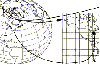
 AllTrans can be used for world wide professional coordinate transformations between international and national coordinate systems with or without geodetic datum change.
Transformations between State-Plane-Coordinates (NAD83, NAD27, Transverse Mercator, Lambert, Soldner-Cassini, Mercator, EOV,...
AllTrans can be used for world wide professional coordinate transformations between international and national coordinate systems with or without geodetic datum change.
Transformations between State-Plane-Coordinates (NAD83, NAD27, Transverse Mercator, Lambert, Soldner-Cassini, Mercator, EOV,...
Platforms: Windows
| License: Demo | Cost: $99.00 USD | Size: 4.41 MB | Download (470): AllTrans Download |
Released: August 19, 2012
|
Added: August 19, 2012 | Visits: 657
 The Eye4Software Coordinate Calculator is an easy to use desktop software tool, to perform gps coordinate conversions from one coordinate system to another. It can also be used to convert coordinates between different map datums. The software can be used to convert a single coordinate, or to...
Platforms: Windows
| License: Shareware | Cost: $43.51 USD | Size: 1.4 MB | Download (462): Coordinate Calculator Download |
Released: September 17, 2012
|
Added: September 17, 2012 | Visits: 501
GISEYE Coordinate Converter software is designed for conversion of coordinates from one map projection into another. List of coordinates and map projection parameters are specified by the user.This software product works under Windows and has an easy-to-use GUI. The application enables to do file...
Platforms: Windows
| License: Shareware | Cost: $29.00 USD | Size: 4.35 MB | Download (458): GISEYE Coordinate Converter Download |
Released: August 03, 2012
|
Added: August 03, 2012 | Visits: 487
 Using advanced mapping techniques, this AutoCAD plug-in gives you the ultimate interface to place your drawings in the real world. Plex.Earth connects AutoCAD with Google Earth and our Web Services in order to provide you a set of unique features. Enhance your design, boost your productivity and...
Platforms: Windows
| License: Shareware | Cost: $109.00 USD | Size: 2.93 MB | Download (448): Plex.Earth Tools for AutoCAD Download |
Released: August 23, 2012
|
Added: August 23, 2012 | Visits: 484
Copan is a very efficient and easy-to-use geomatics engineering tool for computing and managing plane survey coordinates. It does numerous coordinate geometry (COGO) calculations, processes and adjusts raw field survey data, computes and adjusts map traverse data, performs map checks, calculates...
Platforms: Windows
| License: Freeware | Download (444): Copan Download |
Released: July 26, 2012
|
Added: July 26, 2012 | Visits: 491
 XLPoints Plus is the easiest way to massively draw points in AutoCAD and generate 3D models using coordinate data in Excel. Key Features: - Quickly draw points using coordinate data in Excel. - Create new drawings or update existing ones by establishing an open channel with AutoCAD. - Create...
Platforms: Windows
| License: Shareware | Cost: $30.00 USD | Size: 1.66 MB | Download (433): XLPoints Plus Download |